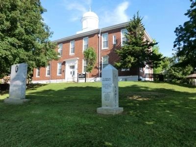
On Court Square at Clark Street, on the left when traveling east on Court Square.
In memory of the
Confederate Soldiers
of Dickson County, TN.
11th Tennessee Infantry, Co. C. E. H. K
49th Tennessee Infantry, Co. B, D
50th Tennessee Infantry, Co. A
10th Tennessee Cavalry
24th Tennessee Sharpshooters
Baxter’s . . . — — Map (db m81508) WM
On Promise Land Road north of Reddon Crossing Road, on the left when traveling north.
The Emancipation Proclamation, issued January 1, 1863, authorized the recruiting of African Americans as United States soldiers. It inspired men, like brothers John and Arch Nesbitt, to join the U.S. Colored Troops and fight for their freedom. John . . . — — Map (db m81504) HM
On Frank Clement Place west of Center Avenue (Tennessee Route 48), on the left when traveling west.
The railroad in front of you follows the route of a vital U.S. Army rail line constructed during the Civil War. After occupying Middle Tennessee in the spring of 1862, Gen. Ulysses S. Grant's officers needed a reliable transportation link between . . . — — Map (db m221789) HM
Dickson County honors Dr. William Dickson, physician, Tennessee Speaker of the House, and member of Congress. County seat, Charlotte, is named for James Robertson’s wife. Dickson’s industrial heritage dates to iron manufacturing propagated by . . . — — Map (db m200223) HM
On City Center Boulevard at City Center Way, on the right when traveling south on City Center Boulevard.
Marion’s Rifles, CSA
In May 1861 over 50 men from the 1st District of Williamson County traveled to Franklin and enlisted in Company H of the 20th Tennessee Confederate Infantry Regiment. Company H was nicknamed Marion's Rifles. This . . . — — Map (db m162883) HM
On North Vine Street 0.1 miles north of Mulberry Street, on the right when traveling north.
The son of C. Hyde and Vina (Hale) Stump, Thomas Jefferson Stump was born in Cheatham County on February 18, 1870 and was educated in Cheatham and Dickson Counties. On October 27, 1895, he married Henrietta Dozier. They had two sons. Stump engaged . . . — — Map (db m151786) HM
On Court Square east of Clark Street, on the left when traveling east.
In 1860, 300 people lived in Charlotte, the Dickson County seat. During the war, the residents witnessed considerable military activity, beginning February 17, 1862, when Confederate Col. Nathan Bedford Forrest, arrived here to reequip his men and . . . — — Map (db m68958) HM
On Center Avenue (State Highway 48) just west of West Walnut Street, on the right when traveling west.
In 1929, the Tennessee State Legislature authorized a memorial building to honor sons and daughters of Dickson County who served in World War I and other wars. A Colonial Revival style structure designed by architect E. H. Woolwine and built by . . . — — Map (db m158683) HM
On Farm to Market Road 861 0.2 miles north of County Road 103, on the left when traveling north.
Pioneer Baptist Minister
Born in Virginia
April 6, 1781 Died December 3, 1844
His Wife Patsy Dixon Parker
Born January 17, 1783 Died December 1, 1846 — — Map (db m245830) WM
Nashville was founded as part of
the movement by British colonists
from North Carolina and Virginia
into the Cumberland Valley in the
mid to late 18th century. Richard
Henderson, a magistrate, judge,
and land speculator from
Granville County, . . . — — Map (db m207200) HM
On Frank Clement Place at Center Avenue, on the left when traveling west on Frank Clement Place.
Country music singer and songwriter John Rich was a member of Lonestar before forming Big & Rich. He has also been a solo artist, radio and television host, and entrepreneur. Outside of music, he has been active in politics and philanthropy. He . . . — — Map (db m221855) HM
On North Main Street north of West College Street (U.S. 70E), on the right when traveling west.
June 4, 1909 - W. E. Cullum and wife, Katie, sold a 25'x125' vacant lot to the W. A Hopkins Lodge #117 of the Knights of Pythias (K. of P.). The K. of P. then added four feet (taken from the adjacent property to the north) to the width of the lot. . . . — — Map (db m304363) HM
On Jackson Hill Road at Camp II Road, on the right when traveling south on Jackson Hill Road.
CCC companies 4497-SP-5 and 3464-NP-16 were among the many companies organized by the U.S.A. during the Great Depression to provide useful employment for thousands of people and at the same time to develop and save our natural resources.
In . . . — — Map (db m151469) HM
On Yellow Creek Road (Tennessee Route 46) south of Old Number 1 Road, on the right when traveling south.
During the Civil War, Yellow Creek's rough terrain and the widespread Confederate sentiment of its inhabitants provided a safe refuge for guerrillas operating in Dickson County and the surrounding area. Regular Confederate cavalry also came through . . . — — Map (db m151419) HM
On Center Avenue, on the left when traveling east.
1899-Town grants railroad permission to build overpass/underground on Charlotte Street, the western edge of the city limits.
1900-Ordinance passed requiring all business to have board sidewalks * Population is 1363 residents
1901-Citizens . . . — — Map (db m124558) HM
Reclaiming Nature
In 1934, agents from the Resettlement Administration and the National Park Service visited Dickson County under petition by local business leaders to evaluate the area’s submarginal farmland and natural resources for a . . . — — Map (db m151473) HM
On Center Avenue, on the left when traveling east.
War Memorial Building Korean & Vietnam
Dedicated to the memory
of the men of
Dickson County Tennessee
Who gave their lives that
freedom might live
1950 Korean Conflict 1955
Bennie E. Bellar
Mack Cavender
Jesse R. Cooksey . . . — — Map (db m125869) WM
On 200 Center Avenue at West Chestnut Street, on the left when traveling east on 200 Center Avenue.
1940-1946
Sacred to the Memory of the Men of Dickson County, Tennessee who died that Freedom might live
Adams, Carl
Adcock, Curtis
Ashworth, Fred W.
Baker, William N.
Bellar, Robert
Black, James L.
Bone, Thomas
Bradford, Elmer . . . — — Map (db m124566) WM
Thin black lines indicate changes in relevance. Between each pair of lines entries are ordered geographically but all have the same relevance.
* Inflectional forms of words are their plurals, singulars, and possessives as well as gramatical tenses and similar variations.