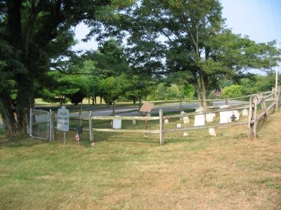
On Bakerton Road at Morning Calm Lane on Bakerton Road.
In this cemetery are buried George Adam Moler (1714–1783) and his wife Eve. George Adam Moler came to American on Aug. 29, 1730 with his father Ludwig Mohler, settling first in Lancaster, Penn. He moved to this area around 1758. He received a land . . . — — Map (db m1962) HM
On South George Street (West Virginia Route 115) at Washington Street ( Route 51), on the right when traveling south on South George Street.
On the site of this Post Office stood the Jefferson County Jail where John Brown and his fellow prisoners were confined after their raid on Harpers Ferry in October 1859.
After court trial John Brown was taken from the Jail here to his death on . . . — — Map (db m2027) HM
On Mordington Ave. at Mordington Rd., on the left when traveling north on Mordington Ave..
Now called Mordington, home of Colonel Charles Washington, founder of Charles Town, Virginia (now West Virginia). His brother General George Washington often visited him here. Colonel Washington died in September 1799. He and his wife Mildred are . . . — — Map (db m12070) HM
On Middleway Pike (West Virginia Route 51) east of Earle Road ( Route 51/1).
Erected in 1771. The home of Colonel Samuel Washington, County Lieutenant. His brother General George Washington visited here and General Lafayette and Luis Phillipe of France were entertained here. In this house James Madison and Dolly Payne Todd . . . — — Map (db m1914) HM
On South Samuel Street south of Hunter Street, on the left when traveling south.
Within these grounds a short distance east of this marker is the site of the scaffold on which John Brown, leader of the Harpers Ferry raid, was executed December the Second, 1859. — — Map (db m12603) HM
On Middleway Pike (West Virginia Route 51) at Earle Road, on the right when traveling east on Middleway Pike.
Here, August 21, 1864, General Philip H. Sheridan's Federal forces were defeated by General Jubal A. Early. The fighting swept over such fine old estates as Harewood, Sulgrave, Tuscawillow, Cedar Lawn, and Locust Hill, still marked by shot and shell. — — Map (db m157728) HM
On North Fairfax Boulevard at East Beltline Avenue, on the right when traveling south on North Fairfax Boulevard.
Why is Beltline Avenue named Beltline? In order to expedite access to rail service, directors of the Charlestown Mining, Manufacturing, and improvement Company had a rail line (known as a belt line) built along what is now Beltline Avenue which . . . — — Map (db m249903) HM
On South Mildred Street just north of West 3rd Avenue, on the left when traveling north.
This Romanesque Revival building built by Julius C. Holmes in 1891 was the headquarters for the Charlestown Mining, Manufacturing & Improvement Company. The owners hoped to create an industrial center in the Eastern Panhandle.
But due to the . . . — — Map (db m249895) HM
On South George Street north of West 2nd Avenue, on the left when traveling north.
In the early spring of 1891, the Goetz Harness and Collar Factory became the second business to agree to set up shop in Ranson. A. D. [Adam Drinkhouse] Goetz, a harness maker considered to be one of the few expert leather men of the world, was . . . — — Map (db m249904) HM
On North Mildred Street (West Virginia Route 115) at West Beltline Avenue, on the left when traveling north on North Mildred Street.
In 1893 Elmer E. Beachley purchased property bordered by Powhatan Brass & Iron and North George Street. He built a two-story building facing Beltline where he operated a Sash Factory & Planing Mill. Unfortunately, by 1896 Beachley's factory was . . . — — Map (db m249902) HM
On North Mildred Street (West Virginia Route 115) just north of Ranson Park Alley, on the left when traveling north.
In January 1891 a foundry owned by Boonton Brass and Iron Works of Boonton, New Jersey relocated to Charles Town. They broke ground on January 6th, and seven weeks later "the steam was turned on." The new foundry was built on a four-acre parcel . . . — — Map (db m249901) HM
On West 2nd Avenue at North Lawrence Street, on the left when traveling west on West 2nd Avenue.
In the years after World War I, the US began switching over from horses and mules to automobiles and none suffered more in the transition than the Goetz Harness Factory. By the start of World War II, the factory had ceased production and the . . . — — Map (db m249905) HM
Near Church Street, on the right when traveling south.
These weathered ruins are all that remain of St. John's Episcopal Church - one of Harpers Ferry's five earliest churches. Built in 1852 with money provided by church fairs, St. John's served as a hospital and barracks during the Civil War and . . . — — Map (db m18790) HM
On Flowing Springs Road (County Route 17) at County Route 17/2, on the right on Flowing Springs Road.
Within these grounds is the home of General William Darke (1736-1801), who served as officer in American Revolution and in St. Clair's 1791 expedition against Miami Indians in Ohio. He served as delegate to the Virginia Convention called 1788 to . . . — — Map (db m5347) HM
On Winchester Avenue (U.S. 11) at Packhorse Ford Road, on the right when traveling south on Winchester Avenue.
First road constructed in the present Berkeley and Jefferson Counties of West Virginia. Built ca. 1727, it followed the route of an older Indian path that was a branch of the Warrior’s Path. — — Map (db m134052) HM
On Kanawha Trail (Virginia Route 311) 0.3 miles south of Sweet Springs Lane, on the right when traveling south.
Just over the state line in West Virginia is the grave of physician and politician John Floyd. He was born in Jefferson County, Virginia (now Kentucky), on 24 Apr. 1783. He married Laetitia Preston in 1804 and received his medical degree from the . . . — — Map (db m295842) HM
On Washington Court just west of West Washington Street (Alternate U.S. 340), on the left when traveling west.
No county in West Virginia experienced more of the Civil War—or suffered more from that war—than Jefferson County.
Situated on the border of North and South, with the Potomac River forming its northern border, Jefferson County could not . . . — — Map (db m249865) HM
On Baxter Street at Warfield Way, on the left when traveling east on Baxter Street.
Charles William Warfield, Sr. was born on December 8, 1870 in Harpers Ferry, West Virginia. He was the second child of James Oscar & Elizabeth (née Robinson) Warfield. Not much is known about his childhood. He married Mary Margaret (née Crane, . . . — — Map (db m267749) HM
History passed through the town of Shepherdstown for centuries. Native Americans cross the Potowomack River at the ford below the bluffs. German settlers crossed at Packhorse Ford as they emigrated from Pennsylvania into Virginia's Shenandoah . . . — — Map (db m60706) HM
On Lord Fairfax Parkway (U.S. 340), on the right when traveling south.
West Virginia. (Jefferson County). “The Mountain State”—western part of the Commonwealth of Virginia until June 20, 1863. Settled by the Germans and Scotch-Irish. It became a line of defense between the English and French . . . — — Map (db m1783) HM
On S. Duke Street, on the right when traveling south.
On Wednesday, September 17, 1862, twelve-year-old Mary Bedinger, asleep at her home Poplar Grove outside Shepherdstown, was awakened by the roar of cannons. Confederate and Union forces in position near Sharpsburg, Maryland, just across the Potomac . . . — — Map (db m41694) HM
On George Street at Washington Street on George Street.
Jefferson County's Most Famous Trial
In the room immediately behind this wall, the abolitionist John Brown and five of his raiders were tried for treason against the state of Virginia, murder and inciting slaves to rebel. Brown had led 21 men . . . — — Map (db m21767) HM
On East German Street (State Highway 45) at Princess Street (County Route 230), on the right when traveling west on East German Street.
In 1775, Shepherdstown (formerly known as Mecklenburg) was asked to furnish one company (about 100 men) to assist patriots fighting the British around Boston. In July, the company marched in high spirits down German Street with the entire town . . . — — Map (db m4851) HM
Near Charmian Road east of Buchanan Trail East/Waynesboro Road, on the left when traveling east.
To spark a civil war, John Brown came to Ritner Boarding House in Chambersburg, PA, where he began to plan his famous raid on Harper’s Ferry, in 1859. At the time, Brown was calling himself Isaac Smith. By mid summer, he had rented the Kennedy . . . — — Map (db m202048) HM
On Washington Street, on the right when traveling west. Reported permanently removed.
As you explore Jefferson County’s Civil War sites, you will learn about some of the notable exploits on the native soil of Thomas J. “Stonewall” Jackson, one of the war's most famous figures. Jackson was born in Clarksburg, Virginia (now West . . . — — Map (db m155096) HM
On South Mt. Parvo Street at West Congress Street, on the right when traveling south on South Mt. Parvo Street.
This 5.26-acre waterside community park was created through a collaborative effort by the City of Charles Town, the Evitts Run Conservancy, the U.S. Environmental Protection Agency, and the West Virginia Department of Environmental PRotection. . . . — — Map (db m148888) HM
On Route 9 Bike Path 0.4 miles south of Luther Jones Road (County Road 16/4), on the right when traveling north.
On the east side of WV 9 is one of the oldest standing frame (post and beam) buildings in West Virginia. It was constructed in three sections, with the oldest, 1½-story eastern section dating between 1751 and 1755. The voids between the studs . . . — — Map (db m207032) HM
On Route 9 Bike Path 0.7 miles north of Leetown Road (County Road 1), on the right when traveling south.
Traveller's Rest
Traveller's Rest is the site of a pre-Revolutionary War, 1½-story limestone dwelling and several log, wood frame, and masonry outbuildings. The property is listed in the National Register of Historic Places and . . . — — Map (db m150614) HM
On E Congress Street at S Church Street, on the right when traveling east on E Congress Street.
The present church, the fourth on this site, was completed in 1851. Federal troops occupied it during the Civil War and severely damaged it. The churchyard contains the graves of many Washington family descents. They are buried near the eastern . . . — — Map (db m41675) HM
On Mansfield Drive (U.S. 250) at North Main Street (U.S. 250), on the right when traveling east on Mansfield Drive. Reported permanently removed.
Col. Benjamin F. Kelley
Kelley, a railroad agent in Philadelphia and former resident of Wheeling, was called back to command the First Virginia (Union) Infantry--the first Union regiment raised in the South. He planned and led the attack on . . . — — Map (db m308160) HM
On Summit Point Road (County Road 13) 0.2 miles west of McCormack Lane, on the right when traveling east.
1730 John and Isaac Van Meter, sons of Dutch immigrant Jobst Jansen Van Masteren, obtained grants for 40,000 acres in then Berkeley County, VA. from Virginia Lt. Gov. Gooch.
1731 Jost Hite, a German immigrant, purchased this land . . . — — Map (db m173642) HM
On Kearneysville Pike (West Virginia Route 480) at Starkey's Landing, on the right when traveling north on Kearneysville Pike.
Patriots March to the Aid of Washington and American Independence
When news of the Battle of Lexington reached Shepherdstown in 1775, most of its able bodied men sprang to arms. The Continental Congress's request for two companies of . . . — — Map (db m269291) HM
On Melvin Road (County Road 17/2) 0.1 miles Flowing Springs Road (County Road 17), on the right when traveling east.
This station structure was erected in 1839 by landowner Richard Duffield, in cooperation with the Baltimore & Ohio Railroad. It is the oldest surviving purpose-built freight/passenger rail station in the United States, and is listed on the . . . — — Map (db m157741) HM
Thin black lines indicate changes in relevance. Between each pair of lines entries are ordered geographically but all have the same relevance.
* Inflectional forms of words are their plurals, singulars, and possessives as well as gramatical tenses and similar variations.