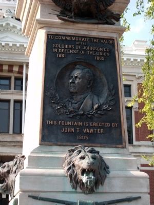
On Jefferson Street at North Main Street, on the right when traveling east on Jefferson Street.
To Commemorate the Valor
of the
Soldiers of Johnson Co.
In defense of the Union
1861 ———— 1865
— ∮— ( Relief ) — ∮—
This fountain is erected by
John T. . . . — — Map (db m55608) HM
On Jefferson Street at North Main Street, on the right when traveling east on Jefferson Street.
( Side One )
In Honor of All Revolutionary War
Soldiers and Patriots
Buried in Johnson County
Erected
July 2009
( Side Two )
—∮— (D.A.R. - Crest) —∮—
Alexander . . . — — Map (db m55609) WM
On Jefferson Street at East Court Street, on the right when traveling east on Jefferson Street.
( Marker Front )
( Center Section )
—∮— (The Great Seal) —∮—
Dedicated to these Johnson
County men who, in answering
the call of duty, paid the
Price of Freedom
– (Seal) . . . — — Map (db m55786) WM
On Center Street at East Main Street, on the left when traveling north on Center Street. Reported missing.
Trailblazing basketball coach Ray Crowe of Johnson County excelled at multiple sports at Whiteland High School and Indiana Central College in the 1930s before beginning a career in education. In 1950, he became head basketball coach at . . . — — Map (db m289108) HM
Near West South Street at Ninevah Street, on the right when traveling west.
born in Cannonsburg, PA, came to Indiana in 1819; elected Clerk of the Indiana House of Representatives in 1820; chosen first Judge of the New Purchase in 1822; first Judge to hold court in Indianapolis; held first court in Johnson County at John . . . — — Map (db m221852) HM
On East Jefferson Street at East Court Street, on the right when traveling west on East Jefferson Street.
We support all military men and women, especially those who made the ultimate sacrifice. May they always be remembered for their service to the nation, in the hearts of those they loved and in the hearts of those who cherish freedom.
May we . . . — — Map (db m315376) WM
On North Main Street at West Jefferson Street, on the right when traveling north on North Main Street.
The Artcraft Theatre was built on the site of the first Johnson County Courthouse. It opened on November 1, 1922 as a silent movie and vaudeville house. In 1936, Trueman Rembusch, a theatre entrepreneur from Shelbyville, purchased the Artcraft . . . — — Map (db m314401) HM
On Grizzly Drive east of State Street, on the left when traveling east.
The Franklin Wonder Five dominated
Indiana basketball in the 1920s as the
sport’s popularity grew dramatically.
The team won an unprecedented three
consecutive state championships at the
high school level from 1920-1922. After
graduating, . . . — — Map (db m206696) HM
On U.S. 31 south of State Road 144, on the right when traveling north.
Founded in 1823, is the home of Franklin College, 1834 and the birthplace of two Indiana governors, Paul V. McNutt, 1891, at 599 E. Adams and Roger D. Branigin, 1902, at 205 Yandes. Johnson County Historical Museum at 150 W. Madison, Indiana Masonic . . . — — Map (db m236562) HM
On West Jefferson Street at Walnut Street, on the left when traveling west on West Jefferson Street.
Founded in the spring
of 1823 by George King,
Franklin, Indiana serves
as the county seat for
Johnson County. After
clearing land near the
mouth of Hurricane
Creek, King and his
three companions would
layout the foundations
for what would . . . — — Map (db m289104) HM
On N. Yandes St south of E. Adams St, on the right when traveling south.
As Indiana's 42nd governor 1965-1969, championed equal opportunity in education and housing. Earned degrees from Franklin College and Harvard University. Deputy prosecutor of Johnson and Brown counties 1926-1929. Practiced law in Franklin, . . . — — Map (db m66820) HM
On West 100 North 0.2 miles west of Indiana Route 144, on the right when traveling west.
Built in 1870 to board Hopewell Academy students from across the state, this house was operated as such until 1884 when Indiana's public school system was established. Academy principal David Moore supervised building the house on ground bought for . . . — — Map (db m221859) HM
Near North Blackford Street north of Indianapolis Cultural Trail, on the right when traveling north.
U.S. Army Camp Atterbury opened in 1942 on 40,351 acres of land in Johnson County. The base served as the training ground for 275,000 soldiers during World War II. As a portion of this land gradually became acquired by Indiana for recreation, it . . . — — Map (db m238794) HM
Near North Blackford Street north of Indianapolis Cultural Trail, on the right when traveling north.
U.S. Army Camp Atterbury opened in 1942 on 40,351 acres of land in Johnson County. The base served as the training ground for 275,000 soldiers during World War II. As a portion of this land gradually become acquired by Indiana for recreation, it . . . — — Map (db m238990) HM
On East Jefferson Street at North Crowell Street, on the right when traveling west on East Jefferson Street.
Founded in the spring of 1823 by George King, Franklin, Indiana serves as the county seat for Johnson County after clearing land near the mouth of Hurricane Creek, King and his three companions would layout the foundations for what would become . . . — — Map (db m314076) HM
On State Road 144 west of North Centerline Road, on the right when traveling west.
Site of presentation of an American Flag to Company F. 7th Indiana volunteer Infantry Regiment August 20, 1861. The 34-star flag, sewn by ladies of Hopewell Presbyterian Church, was received at a farewell picnic in a grove on the John H. Van Nuys . . . — — Map (db m66782) HM
On South Main Street just south of West Main Cross Street, on the left when traveling south.
Laid out in 1822, Edinburg was first town in Johnson County. In 1976 known as the Black Walnut Veneer Capital of the World.
Alexander Thompson and Louis Bishop proprietors of town with additions at once by Isaac Collier, William Hunt, John . . . — — Map (db m236545) HM
Near Sand Road SE (County Highway W66) at Napoleon Street, on the left when traveling south.
When Meskwaki tribes were encamped along the Cedar and Iowa Rivers, they met Stephen Sumner Phelps, who established the first trading post west of this site as early
as 1826. He took John Gilbert, another trader, into his company. Gilbert built . . . — — Map (db m205627) HM
Near West South Street at Ninevah Street, on the right when traveling west.
1861 1865
To honor and
commemorate the men
from
Johnson County, Indiana
who fought in the
Civil War
Erected by
Lincoln Chapter Daughters of the Union
May 30, 1940 — — Map (db m221856) WM
On West Stones Crossing Road (County Road 700 N) at State Road 135, on the right when traveling west on West Stones Crossing Road.
Stone's Crossing was named for Elijah ‘Old Man’
Stone and his family – first wife Elizabeth Ann Taylor
and their nine children and second wife Rachel
Dorrell Lampkins and their daughter. Stone came
from Ohio to Indiana as a youth in 1816 and . . . — — Map (db m289110) HM
On North Main Street (Business U.S. 65) at West Rush Avenue, on the right when traveling south on North Main Street.
In memory of those who were killed in the Mountain Meadows Massacre, in September of 1857. Dedicated in 2020.
Modern historical research has yielded information which was not readily available to those who designed the 1955 monument. . . . — — Map (db m225251) HM
On South Mauxferry Road at East County Road 300 South, on the right when traveling south on South Mauxferry Road.
Young's Creek Cemetery Association
was organized in 1950 through the
efforts of Marcia Adams Pritchard,
President. Other officers were
Clarence DeCoursey, Vice President and
Omer Paul Dawson, Secretary Treasurer.
1984 Board of . . . — — Map (db m289114) HM