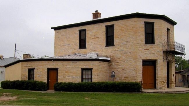
On El Paso Street at James Street, on the left when traveling west on El Paso Street.
Italian stonemasons Giovanni B. Filippone (1845-1917) and Giovanni Cassinelli purchased property here in 1883-85 and in 1885 built the six-sided portion of this limestone block building. Filippone became sole owner in 1887 and operated a general . . . — — Map (db m55428) HM
On Main Street (State Highway 240) at Madison Street, on the right when traveling west on Main Street.
Created Feb. 2, 1856, from Kinney county. Organized July 13, 1871. Named for Texas Revolution veteran, signer of declaration of Independence, Texas Legislator Samuel A. Maverick (1803-1870). The county centers in an area of dairies, farming, . . . — — Map (db m239955) HM
On Ann Street (Ranch to Market Road 674), on the right when traveling north.
Kinney County’s first jail, a small square simple stone structure built by James Cornell in 1873 and torn down in 1922, stood across Ann Street on the courthouse grounds, where the flagpole now stands. This second county jail was accepted by the . . . — — Map (db m55425) HM
Near Swim Park Lane west of Fort Clark Road, on the right when traveling north.
As the ninth largest springs in Texas and the largest springs in Kinney County, Las Moras Spring is significant due to its location and invaluable natural resources. Moras, meaning “mulberries” in one Spanish translation, refer to the . . . — — Map (db m186813) HM
On Waring Walfare Road 0.4 miles north of Little Joshua Creek Road, on the right when traveling north.
Carl Joseph and Augusta Beseler and their two sons immigrated from Germany to Texas in 1848. They settled in Kendall County on a land grant in the 1850s. The community of Welfare was established on the Beseler Land Grant. The Beselers' son Ernst . . . — — Map (db m188513) HM
On Patton Road at Fort Clark Road, on the right when traveling east on Patton Road.
Constructed in 1932, this building replaced an earlier Fort Clark Post Hall that served as a church, courtroom, theater, and recreational center. A utilitarian military design of clear span construction, brick walls, and a stucco veneer, the . . . — — Map (db m55431) HM
On Colony Row at Patton Drive, on the right when traveling south on Colony Row.
These two buildings date from 1854-55, soon after the U.S. Army established Fort Clark. The antebellum fort then included officers quarters and barracks for enlisted men, as well as a two-story quartermaster storehouse, powder magazine, hospital, . . . — — Map (db m55421) HM
Under Spanish rule, Florida was a haven for freed or escaped slaves in the 1700s. Once there, many integrated into the Seminole tribe, intermarrying and adapting to the culture. Florida became a U.S. territory in 1821, and after approximately 30 . . . — — Map (db m55323) HM
Near Sam Houston Street north of Avenue C, on the right when traveling north.
(Panel One)
Thomas T. Perry
(1853-1943)
Thomas T. Perry was born March 12, 1853 in Murfreesboro, Tennessee. He came to San Antonio, Texas, as a young man, learning the craft of stone while masonry working for the Southern . . . — — Map (db m94577) HM
On South Ann Street (Farm to Market Road 674) at James Street, on the left when traveling north on South Ann Street.
Human inhabitation of Kinney County began thousands of years ago. Spanish expeditions through the area began in 1535 and continued throughout subsequent centuries. An attempt at establishing a Franciscan mission in 1775 failed, as did settlement by . . . — — Map (db m56235) HM
This ground was Fort Clark’s military cemetery from 1856 to the 1880s. One of the first burials was 2nd Lt. Brayton C. Ives, 1st Inf., a West Point graduate who died here on June 27, 1857. Succeeding burials included dozens of military personnel, . . . — — Map (db m55430) HM
On Ann Street (Ranch to Market Road 674) at Cook Alley, on the left when traveling north on Ann Street.
Built in 1878-1879 to serve as the first county-owned courthouse for Kinney County, this structure served that purpose for thirty-two years. In 1911 it became the headquarters of the Las Moras Masonic Lodge, which was chartered in 1876. While the . . . — — Map (db m248124) HM
On North Street at Fritter Street, on the left when traveling north on North Street.
In 1885 Dr. William Partrick commissioned adjoining commercial spaces at this site, operating a drug store in the single story and a dry goods store and hotel in the two-story section. Later outbuildings included a beer vault, windmill, elevated . . . — — Map (db m55426) HM
Thin black lines indicate changes in relevance. Between each pair of lines entries are ordered geographically but all have the same relevance.
* Inflectional forms of words are their plurals, singulars, and possessives as well as gramatical tenses and similar variations.