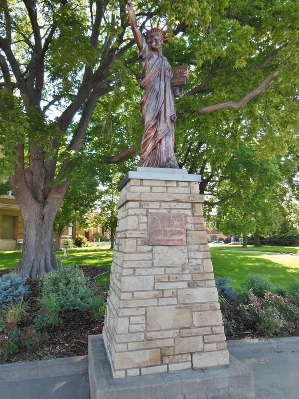
On North Jeffers Street (U.S. 83) at East 3rd Street, on the right when traveling north on North Jeffers Street.
With the faith and courage of their forefathers who made
possible the freedom of these United States
The Boy Scouts of America
dedicate this copy of the
Statue of Liberty as a pledge of everlasting fidelity and
loyalty The Crusade . . . — — Map (db m125079) HM
Mammoths roamed Nebraska's grasslands for more than one million years before mysteriously disappearing between 11,000 and 10,000 years ago. These extinct relatives of today's elephants were the largest mammals ever to walk the Great Plains. Adult . . . — — Map (db m54358) HM
Erected on the Oregon Trail, four miles east of Fort McPherson, Lincoln County, Nebraska, and used as fur trading post and ranch house. 1860 – 61 Used as Pony Express Station. 1862 – 1931 Used as Overland Trail Stage Station, dwelling, . . . — — Map (db m86773) HM
Near North Buffalo Bill Avenue 0.8 miles north of Lincoln Highway (U.S. 30), on the right when traveling north.
You are standing in front of a typical scene found in most farmyards in Lincoln County. A windmill and cistern were vital to the survival of both humans and livestock, especially during the hot, dry Nebraska summers. The windmill allowed farmers and . . . — — Map (db m191774) HM
Near North Buffalo Bill Avenue 0.8 miles north of Lincoln Highway (U.S. 30), on the right when traveling north.
This giant plow was used to dig drainage ditches along the Nemaha River in eastern Nebraska, the Platte River here in Lincoln County, the Medicine Creek south of here in Frontier County, near Big Springs, Nebraska, and in Colorado and Wyoming. . . . — — Map (db m191851) HM
Near North Buffalo Bill Avenue 0.8 miles north of Lincoln Highway (U.S. 30), on the right when traveling north.
This schoolhouse was located four miles north and four miles west of Hershey, Nebraska and was called "Lower Birdwood". On January 22, 1892, the representatives from both the State of Nebraska and Lincoln County signed an agreement claiming this as . . . — — Map (db m191860) HM
Near North Buffalo Bill Avenue 0.8 miles north of Lincoln Highway (U.S. 30), on the right when traveling north.
This log blacksmith shop and its sister station building, which was a two-story log house, were originally located on the Upper 96 Ranch four miles east of Fort McPherson near the Sam Machette Canyon. In 1931, the log house was dismantled and taken . . . — — Map (db m191700) HM
On 2nd Street at Main Street, on the right when traveling north on 2nd Street.
The Chief of Fort Robinson Scouts, Baptiste “Little Bat” Garnier was shot by James Haguewood, bartender, in this building known as Dietrich’s Saloon, December 16, 1900. “Little Bat” died near the center of the street intersection about 3 a.m. and . . . — — Map (db m235888) HM
On North Jeffers Street (U.S. 83) north of East 3rd Street, on the right when traveling north.
In commemoration of the
”Old Glory Blowout” July 4, 1882
This event held in Lincoln County
Nebraska, was the manifestation of a dream
that became a reality as the:
”Buffalo Bill’s Wild West”
and was . . . — — Map (db m125081) HM
On West Walker Road 0.9 miles west of South Buffalo Bill Avenue, on the left when traveling west.
(side 1) Dedicated June 15, 2002
Cold Springs added station
Jul. 1, 1861 – Nov. 20, 1861
Located 1600’ south by Lincoln County
James Stretesky Nebraskaland Days, Inc.
Nebraskaland National Bank
North Platte/Lincoln . . . — — Map (db m125063) HM
Near North Buffalo Bill Avenue 0.8 miles north of Lincoln Highway (U.S. 30), on the right when traveling north.
This cabin was built in 1866 by R. E. Rowland out of native cedar found in the hills south of the Platte River. As a freighter to the town of Cottonwood Springs, near Maxwell, Nebraska, Rowland needed living quarters while staying in the area. . . . — — Map (db m242017) HM
Near North Buffalo Bill Avenue 0.8 miles north of Lincoln Highway (U.S. 30), on the right when traveling north.
This log, two-story, cedar log structure was built in 1868 or 1869 by Mr. E.E. Ericsson. Each log is shaped and interlocked with the next with a minimal use of square nails. Mr. Ericsson was born in Varmland, Sweden on July 1st, 1835. He arrived . . . — — Map (db m191768) HM
Near North Buffalo Bill Avenue 0.8 miles north of Lincoln Highway (U.S. 30), on the right when traveling north.
This flagpole stood above Fort McPherson from 1877 to 1882 when it was removed and put in storage. It was later donated to the Lincoln County Historical Museum. Of what you can see here today the only original part is the main flagpole itself. The . . . — — Map (db m191703) HM
Panel 1
Arriba
In frontier Arriba (locally pronounced "AIR-uh-buh"), the only thing
more scarce than water was whiskey. Charles Creel, who founded
the town in 1888 to greet the advancing Chicago, Rock Island &
Pacific . . . — — Map (db m89381) HM
Thin black lines indicate changes in relevance. Between each pair of lines entries are ordered geographically but all have the same relevance.
* Inflectional forms of words are their plurals, singulars, and possessives as well as gramatical tenses and similar variations.