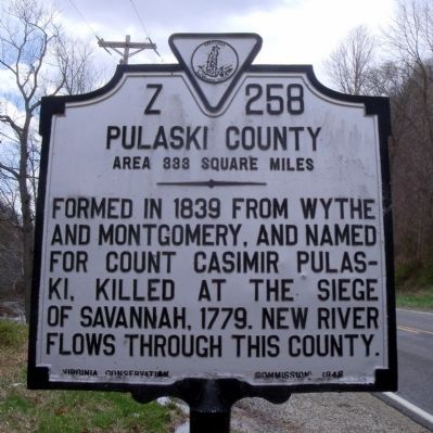
On Pulaski Giles Turnpike (Virginia Route 100) 0.3 miles north of Little Creek Road ( Route 601), on the right when traveling north.
Giles County. Area 369 square miles. Formed in 1806 from Montgomery, Tazewell, and Monroe, and named for William B. Giles, United States Senator and Governor of Virginia, 1827-1830. Mountain Lake is in this county.
Pulaski . . . — — Map (db m41442) HM
On Lee Highway (U.S. 11) at Hazel Hollow Road ( Route 626), on the right when traveling north on Lee Highway.
Montgomery County. Area 401 square miles. Formed in 1776 from Fincastle, and named for General Richard Montgomery, killed at Quebec, 1775. The Virginia Polytechnic Institute is in this county.
Pulaski County. Area . . . — — Map (db m41416) HM
On Stony Fork Road (U.S. 52) near West Blue Grass Trail ( Route 42), on the right when traveling south.
Samuel H. Newberry, a captain in the Confederate army who represented Bland and Pulaski Counties in the Virginia House of Delegates from 1865 to 1867, lived here at Eagle Oak. Newberry served in the Senate of Virginia during the 1870s and 1880s and . . . — — Map (db m43138) HM
Near Ben H Bolen Drive 0.1 miles east of State Park Road ( Route 660).
This chimney, formerly to the home of William Christian, brother-in-law to Patrick Henry & frontier militia commander, was built about 1772 a mile down stream at a site now submerged by Claytor Lake. In 1808 it became the home of Thomas Cloyd from . . . — — Map (db m286317) HM
On Riner Road (County Route 8) just south of Homestead Road.
Floyd County. Floyd County was named for John Floyd, governor of Virginia from 1830 to 1834. The county was formed from Montgomery County in 1831, with a portion of Franklin County added later. The county seat is Floyd, formerly Jacksonville. . . . — — Map (db m104299) HM
Near Golden Isles Parkway (U.S. 341) at North Florida Avenue, on the left when traveling west.
Pulaski County was created in 1808 and named for Count Casimir Pulaski. He was a Polish born Brigadier General and hero during the American Revolution who was mortally wounded at Savannah, Georgia in 1779. Hawkinsville became the county seat in . . . — — Map (db m174537) HM
On Unruh Drive east of Robertson Street, on the left when traveling east.
The settlement of lands west of the Blue Ridge began in the mid-18th century, spurred by both the need for more land and the desire to push the frontier westward to create a buffer protecting eastern Virginia. Whereas most settlers of the east were . . . — — Map (db m209657) HM
On West 18th Street at Baynard Boulevard on West 18th Street.
African American Medal of Honor Recipients Memorial
The Medal of Honor takes its place in our country as the highest award for military valor. The honor, awarded by the President in the name of Congress, may only be accorded an . . . — — Map (db m173924) HM WM
On Riverhaven Drive (Virginia Route 114), on the right when traveling east on Riverhaven Drive.
Montgomery County. Area 401 Square Miles. Formed in 1776 from Fincastle, and named for General Richard Montgomery, killed at Quebec, 1775. The Virginia Polytechnic Institute is in this county.
Pulaski County. Area . . . — — Map (db m50619) HM
"Jeremiah Vardeman was a distinguished minister somewhat rare in the annals of the church. He possessed the peculiar talent of bringing the leading truths of the gospel home to the consciences of his hearers his illustrations were singularly . . . — — Map (db m244374) HM
On Unruh Drive 0.1 miles Robertson Street, on the left when traveling east.
Throughout the 1880s and 1890s the Lovely Mount, Central Depot and newly developed Radford areas grew as more coal and iron passed through the region and more factories were built. Because of the growth brought by this development the area reached . . . — — Map (db m209654) HM
On Medal of Honor Way 0.1 miles east of Lee Highway (U.S. 11), on the right when traveling east.
Corporal Lewis Kenneth Brusell was born in Pulaski,
Virginia on April 17, 1924. He enlisted in the United States
Marine Corps at the age of 17 following the bombing of
Pearl Harbor. Corporal Bausell served with the 5th Marine
Regiment of the . . . — — Map (db m228247) HM WM
Thin black lines indicate changes in relevance. Between each pair of lines entries are ordered geographically but all have the same relevance.
* Inflectional forms of words are their plurals, singulars, and possessives as well as gramatical tenses and similar variations.