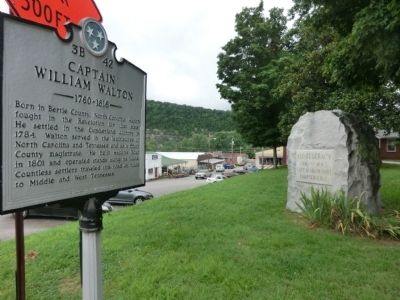
On Main Street north of 2nd Avenue, on the left when traveling north.
Born in Bertie County, North Carolina, Walton fought in the Revolution for that state. He settled in the Cumberland country in 1784. Walton served in the legislatures of North Carolina and Tennessee and as a Smith County magistrate. He built . . . — — Map (db m68351) HM
On Lancaster Highway at Stewarts Bend Lane, on the right when traveling north on Lancaster Highway.
At this crossing on April 24, 1949; Tennessee Central Freight No. 81 struck a heavily loaded pickup truck killing ten members of the Bennett Family. The truck was pushed 100 yards west down the tracks. This became Smith County's worst tragedy in . . . — — Map (db m145758) HM
On West Main Street east of Greenwood Street, on the right when traveling west.
Born in Smith County in 1800, Caruthers was elected Confederate Governor in 1863. However, due to the Federal occupation of Tennessee, he was not inaugurated. A co-founder of Cumberland University, he served in the Tennessee House of Representatives . . . — — Map (db m68364) HM
On Clover St. (Tennessee Route 96), on the left when traveling east.
The Civil War experiences of Granville, an important Cumberland River port in the nineteenth century, were similar to many rural Upper Cumberland communities. When Tennessee seceded in 1861, most residents backed the Confederacy.
Granville was . . . — — Map (db m82194) HM
Near Interstate 40 at milepost 267, 1 mile west of Medley Amonette Road ( Route 96) when traveling west.
Welcome to Smith County, Tennessee!
Get ready to visit small towns with big stories.
Tennessee Civil War Trails tells riveting stories of battles and leaders, and much more. You'll learn about some of the state's 275,000 enslaved men and . . . — — Map (db m268180) HM
On Main Street at 2nd Avenue, on the left when traveling north on Main Street.
Carthage’s historic courthouse square was the control center of a major Federal base from 1863 to 1865 in the fight to control the Upper Cumberland
River region. When Union Gen. George Crook arrived in Carthage to stay in 1863, he commandeered the . . . — — Map (db m68353) HM
This Monument Was erected by the liberality of the Citizens of the County of Sumner to the memory of her Patriotic Sons: who sacrificed their lives in the defense of the Flag of their country in the war with Mexico. In 1846. 1847 & 1848. . . . — — Map (db m85162) WM
On West 70th Street 0.4 miles west of Shiloh Avenue, on the right when traveling west.
Susan C. Haile was born December 20, 1817, in Cape Girardeau, Missouri. She was the youngest child of Joseph and Prudence (Bledsoe) Seawell, natives of Sumner County, Tennessee. Upon the death of Joseph in 1819, Prudence Seawell returned to Sumner . . . — — Map (db m123807) HM
On Farm to Market Road 513 at County Road 1624, on the left when traveling north on Road 513. Reported missing.
Prominent Hunt County pioneer (1807-1865) Came to Texas 1840. Granted a 640-acre headright by Republic of Texas. Served as commissioner to organize county and locate county seat. First postmaster of Hooker's Mill settlement where he owned area's . . . — — Map (db m280289) HM
On Main Street North at 3rd Ave W, on the left when traveling north on Main Street North.
A pivotal behind-the-scenes player in popularizing bluegrass music, Louise Scruggs was the wife of banjo player and bluegrass pioneer Earl Scruggs. She managed Earl and his partner, Lester Flatt, from 1956 until they broke up in 1969. Early on, she . . . — — Map (db m263471) HM
On Gordonsville Highway at South Main Street, on the left when traveling south on Gordonsville Highway.
The Carthage Junction Depot has been a landmark for Smith County since the late 1800's, moving passengers and delivering freight and mail along the Tennessee Central Railroad. It was because of this depot that we were able to send our WWI and WWII . . . — — Map (db m224765) HM
On County Highway 157 0.4 miles east of Farm to Market Road 1689, on the left when traveling east.
Pioneer farmer and rancher William Pendergrass (1818-98) and his wife, Emaline (1819 -1907), moved from Tennessee to Smith County, Texas, in 1849. They first came to Comanche County in 1859, then settled here permanently after a brief return to . . . — — Map (db m162139) HM
Born near Elkhart in Anderson County, Alton W. Birdwell was reared in the Piney Woods of East Texas. His early education was provided through home schooling; he earned money for later study by hand-molding clay bricks and hewing railroad ties. . . . — — Map (db m221341) HM
Near Interstate 20 at milepost 538, on the right when traveling west.
A man whose public service was of highest order. Born on a farm near this site in Van Zandt County. Educated at Cumberland University (Tennessee) and Tyler Commercial College, was County Attorney and County Judge of Smith County. As chairman of . . . — — Map (db m84511) HM
On Farm to Market Road 90 at Gordon Lane, on the right when traveling east on Route 90.
Alabama native Edward Thomas Broughton, Jr. (b. 1834) came to Jasper, Texas, with his family in 1847. Broughton married Mary Elizabeth Douglas in 1856. He studied law in Smith County and was admitted to the bar in 1857. By 1860 the Broughtons were . . . — — Map (db m96380) HM
On South Buffalo Street (State Highway 198) south of East Dallas Street (State Highway 64), on the left when traveling south.
John Henninger Reagan was born in 1818 to Timothy Richard and Elizabeth Reagan in Sevier County, Tennessee. He worked at his father's tannery and on the family farm, attending school sporadically, until leaving the state in 1838.
Reagan came in . . . — — Map (db m54002) HM
On North Bois d'Arc Avenue north of West Wilson Street, on the left when traveling north.
(front)
School named for Texas Confederate
Colonel Bryan Marsh
1833-1901
Alabama native, came to Tyler, 1854. 1861 was captain Co. C, 17th Texas Cavalry. In 1863 Confederate campaigns to prevent split of South along . . . — — Map (db m91362) HM
On Upper Ferry Road west of Bypass Route 25, on the right when traveling west.
As a major Cumberland River port with three landings, Carthage was strategically important to both Confederate and Union forces. The Upper Ferry and landing was located near the present Corps of Engineer
boat ramp near Upper Ferry Road. . . . — — Map (db m68349) HM
On Moorman Road at Hillcrest Street, on the left when traveling west on Moorman Road.
Born in Talladega, Alabama, in April 1842, Thomas Oscar (T.O.)
Moore was a civic leader in Comanche. After Moore's father's
business failed in 1854, the family moved to Texas, settling in
Hays County in 1855. By the fall of 1857, the family had . . . — — Map (db m220770) HM
On Farm to Market Road 848 0.1 miles Old Omen Road (County Road 262), on the right when traveling north.
Founded in 1857, Bascom United Methodist Church is one of the
oldest churches in Smith County. It has been and continues to
be an integral part of the community's heritage. Since the
beginning, the church has been sustained by the . . . — — Map (db m310417) HM
On Farm to Market Road 857 at County Road 1707, on the right when traveling west on Road 857.
Providence Community comprised mostly of small family
farms, is located in the far northeast section of Van Zandt
County straddling the Smith County line. Since 1845,
colonization of the area was encouraged with land
grants, and many immigrants . . . — — Map (db m237026) HM
Thin black lines indicate changes in relevance. Between each pair of lines entries are ordered geographically but all have the same relevance.
* Inflectional forms of words are their plurals, singulars, and possessives as well as gramatical tenses and similar variations.