12 entries match your criteria.
Historical Markers in East Kootenay, British Columbia
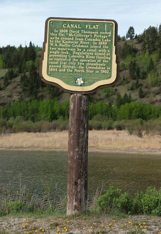
By B.C. Ministry of Transportation and Infrastructure via Flickr (CC BY-NC-ND 2.0)
Canal Flat Marker
| On Kootenay Highway (Provincial Highway 93/95) 1.3 kilometers north of Burns Avenue, on the left when traveling north. |
| On Van Horne Street South (Provincial Highway 3) south of 5th Avenue South, on the right when traveling south. |
| On Provincial Highway 93/95 close to St. Mary's Street. |
| On Kootenay Highway (Provincial Highway 3) 0.8 kilometers east of Ha Ha Creek Road, on the left when traveling south. |
| On Crowsnest Highway (Provincial Highway 3/95) 0.4 kilometers south of Half Moon Avenue, on the right when traveling south. |
| On Crowsnest Highway (Provincial Highway 3/95) 0.3 kilometers south of Half Moon Avenue, on the right when traveling south. |
| On Kootenay Highway (Provincial Highway 93) 2.2 kilometers south of Stanley Street, on the right when traveling south. |
| On Crowsnest Highway (Provincial Highway 3) 0.8 kilometers north of British Columbia-Alberta boundary line, on the left when traveling west. |
| On Crowsnest Highway (Provincial Highway 3) 3.3 kilometers south of Douglas Fir Road, on the right when traveling south. |
| On Crowsnest Highway (Provincial Highway 3) 0.4 kilometers west of Elk Valley Coal Road, on the right when traveling west. |
| On Kootenay Highway (Provincial Highway 93) 0.7 kilometers south of Simpson River Trailhead, on the right when traveling north. |
| On Laurier Street, 0.2 kilometers south of Daly Street, on the left when traveling south. |
Jun. 14, 2024