30 entries match your criteria.
Entries Containing All of the Phrases «mccormick county» AND «south carolina»
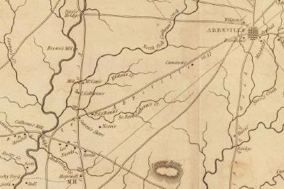
By Mill's Atlas of 1825, 1825
Detail of Mills Atlas of Abbeville District -
Showing Location of Calhoun's Mill
Showing Location of Calhoun's Mill
RANKED BY RELEVANCE
| 1 ► South Carolina, McCormick County, Mt. Carmel — 33-10 — Calhoun Mill |
| Near Mt. Carmel Road (State Highway 823) at State Highway 40. Reported missing. | |||
2 ► South Carolina, McCormick County, Clarks Hill — Thurmond Dam and Lake / McCormick County —  |
| On U.S. 221. | |||
| 3 ► South Carolina, McCormick County, Mt. Carmel — Mt. Carmel Historical District — Village of Remembrance — |
| On Main Street (State Highway 81) at State Highway 95, on the right when traveling north on Main Street. | |||
| 4 ► South Carolina, McCormick County, McCormick — McCormick County / MACK — |
| On North Main Street. | |||
| 5 ► South Carolina, McCormick County, Bordeaux — 33-14 — New Bordeaux (1764) — |
| On SC Road 33-7, on the right when traveling north. | |||
| 6 ► South Carolina, McCormick County, McCormick — McCormick County Confederate Monument — 1861-1865 — |
| On Augusta Street Extension (State Highway S-33-54) 0.1 miles south of Mine Street (U.S. 221). | |||
| 7 ► South Carolina, McCormick County, Willington — Willington — A South Carolina Railroad Village — |
| On SC Highway 81, on the right when traveling north. | |||
| 8 ► South Carolina, Greenwood County, Troy — 24-2 — Long Cane Associated Reformed Presbyterian Church — |
| On Main Street West near Twigg Street (South Carolina Highway 10). | |||
| 9 ► South Carolina, McCormick County, Bordeaux — 33-5 — Guillebeau Home and Family Cemetery — |
| On State Highway 81 at Moss Avenue (Road 196), on the left when traveling west on State Highway 81. | |||
| 10 ► South Carolina, McCormick County, Mt. Carmel — Capture of Fort Charlotte — July 12, 1775 — South Carolina Cradle of Democracy Project — |
| On State Highway 33-91. | |||
| 11 ► South Carolina, McCormick County, Mt. Carmel — 33-1 — Fort Charlotte — |
| On Main Street (State Highway 81) at State Highway 33-91 on Main Street. | |||
| 12 ► South Carolina, Greenwood County, Troy — 24-1 #2 — Long Canes Massacre — |
| On Indian Massacre Road when traveling south. | |||
| 13 ► South Carolina, Abbeville County, Abbeville — 1-5 — Birthplace of Calhoun — |
| On Mt. Carmel Road (State Highway 823). | |||
| 14 ► South Carolina, Abbeville County, Abbeville — The Law Offices of John C. Calhoun — |
| On County Square. | |||
| 15 ► South Carolina, Pickens County, Clemson — Calhoun Plantation Cemetery — |
| Near South Palmetto Blvd at Williamson Drive. | |||
| 16 ► South Carolina, Pickens County, Clemson — 39-9 #1 — Clemson University — |
| On Old Greenville Highway (State Highway 93) west of Newman Road, on the right when traveling west. | |||
| 17 ► South Carolina, Pickens County, Clemson — 39-2 — Fort Hill — |
| On Fort Hill Street, on the right when traveling west. | |||
| 18 ► South Carolina, Pickens County, Clemson — Fort Hill — The Beginning of a Legacy — |
| On Fort Hill Street, on the left when traveling west. | |||
| 19 ► South Carolina, Pickens County, Clemson — John C. Calhoun Memorial Highway — |
| On Calhoun Memorial Highway, on the right when traveling east. | |||
| 20 ► South Carolina, Pickens County, Clemson — 39-5 — Keowee / John Ewing Colhoun — |
| On Six Mile Highway (State Highway 133) at Old Six Mile Road, on the left when traveling north on Six Mile Highway. | |||
| 21 ► South Carolina, McCormick County, Bordeaux — John De La Howe School Lethe Farm Trail — |
| On Tomb Road. | |||
| 22 ► South Carolina, McCormick County, McCormick — 33-9 — Dorn’s Mill / Dorn Gold Mine — |
| On North Mine Street, on the left when traveling south. | |||
| 23 ► South Carolina, McCormick County, McCormick — 33-7 — Battle of Long Cane — |
| On State Highway 28 at Old Charleston Road (Local Road 38), on the left when traveling south on State Highway 28. | |||
| 24 ► South Carolina, Anderson County, Anderson — Building History / Major Frank R Thompson (1903-1977) — |
| Near North Main Street (State Highway 28). | |||
| 25 ► South Carolina, McCormick County, McCormick — Dorn Mill — Production of Cotton Byproducts — |
| On North Main Street. | |||
| 26 ► South Carolina, McCormick County, Bordeaux — John De La Howe School — Still Caring...Still Dreaming — |
| Near Gettys Road (State Highway 81). | |||
| 27 ► South Carolina, McCormick County, McCormick — 33-6 — Badwell / Badwell Cemetery — |
| On Savannah River Scenic Byway (State Highway 28) at Barksdale Ferry Road (County Route S-33-61), on the left when traveling west on Savannah River Scenic Byway. | |||
| 28 ► South Carolina, Oconee County, Walhalla — South Carolina National Heritage Corridor — |
| Near Stumphouse Tunnel Road near State Highway 28, on the right when traveling west. | |||
| 29 ► South Carolina, Greenwood County, Troy — 24-1 — Long Canes Massacre — |
| On Main Street West near Twigg Street (South Carolina Highway 10). | |||
| 30 ► South Carolina, Oconee County, Westminster — 37-20 — Retreat Rosenwald School — |
| On 150 Pleasant Hill Circle, in the median. | |||
Thin black lines indicate changes in relevance. Between each pair of lines entries are ordered geographically but all have the same relevance.
* Inflectional forms of words are their plurals, singulars, and possessives as well as gramatical tenses and similar variations.
Nov. 13, 2026