On Grand Loop Road, on the left when traveling north.
When Steamboat Geyser erupts, it can rocket a column of scalding water 90-120 meters into the air – two to three times the average height of Old Faithful. Steam roars for twenty-four hours after. Odds are against your witnessing this drama, . . . — — Map (db m88323) HM
On North Rim Drive, on the right when traveling east.
The Grand Canyon of the Yellowstone River slices through an ancient hydrothermal basin. The basin developed in rhyolitic lava and ash that flowed into the Yellowstone Caldera about 500,000 years ago. The river carved this spectacular canyon through . . . — — Map (db m88959) HM
Ten times more acidic than lemon juice, Sulphur Caldron sits on the edge of one of the most active areas of Yellowstone's buried volcano. Sulphur-rich gasses rise furiously here, filling Sulphur Caldron with sulfuric acid. Incredibly, this muddy . . . — — Map (db m46268) HM
Near Upper Grand Loop Road, on the right when traveling west.
Yellowstone’s most common tree is the lodgepole pine. Miles and miles of these tall, straight trees grow close together. Lodgepole pines forests need fire to survive. It helps control disease and insects, and fire is essential for a new generation . . . — — Map (db m88911) HM
On Grand Loop Road (U.S. 89), on the right when traveling north.
Bridging the Golden Gate Canyon was one of the most difficult and expensive challenges engineers faced when building the first roads through the park. The first bridge was built in 1885. Twelve hundred seventy-five pounds of explosives were needed . . . — — Map (db m123359) HM
The canyon varies from 800 to 1200 feet in depth
and from 1500 to 4000 feet in width. Its length is about 24 miles. The upper 2½ miles is the most colorful section. Hot spring activity has continued through the ages altering the lava rock to . . . — — Map (db m41398) HM
Near North Rim Drive, 0.9 miles east of Grand Loop Road.
The canyon varies from 800 to 1200 feet in depth and from 1500 to 4000 feet in width. Its length is about 24 miles. The upper 2½ miles is the most colorful section. Hot spring activity has continued through the ages altering the lava rock to . . . — — Map (db m45299) HM
Near Upper Grand Loop Road, on the right when traveling west.
The rocky outcropping in front of you tells part of a violent story of Yellowstone’s volcano – one of the largest volcanoes on Earth. About two million years ago Yellowstone’s volcano – so enormous that it is called a “super . . . — — Map (db m88930) HM
On West Entrance Road, 1 mile west of Grand Loop Road.
From an elk's perspective, this valley offers
everything needed for year-round survival.
Food is abundant. These meadows become
snow-free relatively early and stay lush longer
into summer. During May-June calving season,
nearby lodgepole . . . — — Map (db m46262) HM
Near Grand Loop Road (U.S. 89) near Norris Canyon Road, on the right when traveling south.
The national park idea is often referred to as one of America's greatest contributions to world culture. America's natural and cultural heritage—its very character and soul—is preserved in over 360 units of the National Park System. . . . — — Map (db m45314) HM
Near Grand Loop Road (U.S. 89) near Norris Canyon Road, on the right when traveling south.
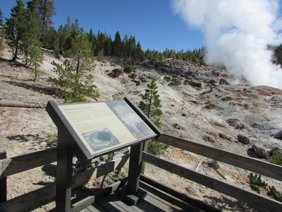
Norris Geyser Basin
You are close to a world of heat and gases where microorganisms live in such massive numbers they add color to the landscape. This strange, beautiful place is on the edge of a giant volcano-the Yellowstone Volcano-one of . . . — — Map (db m45349) HM
On N Entrance Road, on the right when traveling north.
Gathering place, training ground, site of ceremonies and parades – the drill field was the focal point of daily life at Fort Yellowstone. Each day began early with a bugler sounding reveille. Gradually, the fort came to life, and another . . . — — Map (db m87115) HM
On Officers Row, on the left when traveling south.
At the Post Exchange, a soldier with free time could spend it in the gymnasium or bowling alley, or could play cards and drink beer. There may also have been a billiards table, and movies were shown once a week. The building was informally known . . . — — Map (db m87143) HM
Near Grand Loop Road, on the right when traveling north.
Tower Fall is the story of two rocks: easily eroded rocks and rocks that are resistant to erosion. Rock at the brink and underlying the waterfall is a hard volcanic rock. Erosion at the base of the fall causes the upstream migration of the fall. . . . — — Map (db m88305) HM
Near Upper Grand Loop Road, on the right when traveling west.
Roots of Survival The secret of an aspen grove lies hidden beneath the ground. Aspens rarely grow from seeds but spring up abundantly from the roots of their parent. These young shoots are connected to each other underground by an extensive . . . — — Map (db m88920) HM
Near South Rim Drive, 0.6 miles east of Grand Loop Road.
Welcome to Uncle Tom’s Point
Uncle Tom’s Trail
For a memorable descent into the canyon, follow Uncle Tom’s Trail. From there, you can sense the power of Lower Falls as the Yellowstone River thunders over the brink, . . . — — Map (db m45272) HM
Near South Rim Drive, on the left when traveling east.
Shortly after 1900, “Uncle” Tom Richardson took visitors down into the Canyon along this trail. Originally with 528 steps and rope ladders; it now descends 328 steps or about ¾ of the way down in to the Canyon for an excellent view of . . . — — Map (db m88901) HM
Near South Rim Drive, 0.6 miles east of Grand Loop Road.
A waterfall is a clue that you are standing on a geologic crossroads.
A waterfall forms in a river channel where harder rocks meet softer rocks that erode more easily and quickly. Here, volcanic and hydrothermal activity have created the . . . — — Map (db m45275) HM
You are inside a caldera of one of the largest volcanoes in the world! The volcano has erupted at least three times, and Yellowstone is full of signs that volcanic activity is still very much alive below ground.On the Rise Magma is moving and . . . — — Map (db m46265) HM
On Lower Grand Loop Road, on the right when traveling south.
The high cliffs around you were created after the last volcanic eruption in the Yellowstone region, about 630,000 years ago. The powerful eruption ejected ash as far away as Nebraska and Texas, expelling magma from an underground chamber more than . . . — — Map (db m88343) HM
Near North Rim Drive, 0.7 miles east of Grand Loop Road.
Here the Yellowstone River plunges 308 feet over the Lower Falls. Hot springs have weakened the rock jut downstream, where you might see several geysers spouting into the river. As falling water pounds the thermally softened rock, it continues to . . . — — Map (db m45297) HM
Flowers are scattered throughout Yellowstone’s northern landscape from April through September. During winter they lie dormant, waiting to burst into color. Several factors determine what you might see, and where. • How hot or cold has it been . . . — — Map (db m88926) HM
On Firehole Lake Drive, on the left when traveling north.
White Dome Geyser’s beautifully shaped cone is many centuries old, and is still growing with each eruption. For hundreds of years, thermal water has been building the cone that you see today – one of the largest in Yellowstone. Formation of . . . — — Map (db m88390) HM
On E Entrance Road (U.S. 20), on the right when traveling west.
In 1902, the first bridge was built across the outlet of Yellowstone Lake. By 1914, its official name was “Fishing Bridge.” Today’s bridge with walkways was built in 1937. Fishing Bridge had become a popular fishing spot for park . . . — — Map (db m88136) HM
Near Upper Grand Loop Road, on the right when traveling west.
Gray wolves (Canis lupus) are the largest member of the canine family. They are well suited to Yellowstone where winters are long and severe. Wolves move easily over the snow on their large paws, their thick fur keeping them warm. Wolves . . . — — Map (db m88906) HM
Near Grand Loop Road (U.S. 89) near Norris Canyon Road, on the right when traveling south.
Yellowstone has been designated a U.S. Biosphere Reserve, a World Heritage Site, and is one of the largest national parks in the lower 48 states. Its boundaries protect over 10,000 geysers,hot springs, mudpots, and steam vents-the earth's largest . . . — — Map (db m45315) HM
On Grand Loop Road near Stable Street, on the left when traveling south.
Yellowstone National Park Chapel, erected 1913 at the suggestion of Honorable John W. Meldrum, first National Park U.S. Commissioner, and endorsed by Bishop William F. Nichols, Bishop Nathaniel S. Thomas, Bishop James J. Keane,
Brigadier General . . . — — Map (db m123362) HM
127 entries matched your criteria. Entries 101 through 127 are listed above. ⊲ Previous 100