On O'Connell Street, on the right when traveling south.
A Stripped Classical British design, the building is a rare example of the commercial architecture of Basil Hooper who was better known for his Arts and Crafts houses. — — Map (db m222509) HM
Built - 1912 Auckland Harbour Board
Restored - 1988 Challenge Properties Ltd.
Officially opened 5 November 1988 by His Excellency the Governor-General
the Most Reverend Sir Paul Reeves, GGMG, GGVO — — Map (db m222467) HM
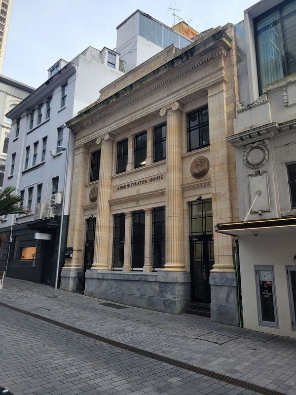
On Shortland close to O'Connell, on the left when traveling west.
The General Building is one of the best preserved Chicago-style high rises in Auckland and is an excellent example of early 'modern' American architecture in New Zealand. — — Map (db m222901) HM
Lord Freyberg V.C., G.C.M.G., K.C.B., K.B.E., D.S.O.
1889 – 1963
Commander of the Second New Zealand Division 1939 – 1945
Governor-General of New Zealand 1946 – 1952
This memorial has been donated by returned servicemen to the citizens of . . . — — Map (db m223831) HM
On O'Connell Street at Chancery, on the left when traveling north on O'Connell Street.
In 1860 a brick courthouse was built on the corner of High and Chancery Streets. It was used as Auckland City Council offices from 1881-1887 and later a dental hospital. Adjacent to the court was a brick police station built in 1864 and used until . . . — — Map (db m222525) HM
Erected by the members of the N.Z. Battery R.A. In memory of their comrades Lieutenant Geo. Leece, Corporal Herbert A. Edwards, Bombardier John Mays, Driver John Beck, Gunners Joseph Brown, Frederick Forbes, Arthur W. Kendall, and Driver Thomas . . . — — Map (db m222474) WM
On Queen Street close to Customs Street E, on the left when traveling south.
This elegant 'stripped classical' building, with a Portland stone facing, was built between 1926 and 1927 for the Dilworth Trust to provide income for philanthropic work. It was reputedly the secret control headquarters for the Battle of Guadalcanal . . . — — Map (db m222482) HM
On Customs Street West, on the right when traveling west.
The sailing vessel most identified with Auckland was the scow, a flat bottomed vessel with a lifting centerboard enabling easy beaching. Based on a North American Great Lakes design, they carried every sort of cargo, but mainly logs, cattle, sand . . . — — Map (db m222462) HM
On Huia Street at Hautapu Street, on the left when traveling east on Huia Street.
This tower was erected to house the clock and chimes that were removed from the post office building in 1943 as an earthquake precaution. The funds were raised by public subscription from Taihape and district.
All materials and labour used in the . . . — — Map (db m223240) HM
Near Buckingham Street north of Villiers Street, on the left when traveling north.
Physical and emotional challenges extended beyond the search for gold. After Guangdong's near tropical climate, the newcomers would have been shocked by by Otago's brutally cold winters and made anxious by local hostility towards them.
A . . . — — Map (db m184767) HM
Near Buckingham Street north of Villiers Street, on the left when traveling north.
From the late 1860s to the 1880s this was one of many camps and settlements established by Chinese gold seekers in Otago-Southland. By the turn of the century, however, most had been abandoned, their simple dwellings left to decay. Today the . . . — — Map (db m184758) HM
Near Te Anau-Mossburn Highway (State Highway 94) 0.5 kilometers west of Lagoon Creek Road, on the left when traveling west.
South West New Zealand is one of the great wilderness areas of the Southern Hemisphere. It is an area where snow-capped mountains, rivers of ice, deep lakes, unbroken forests and tussock grasslands produce a landscape of exceptional beauty. In this . . . — — Map (db m185281) HM
On Commonwealth Walkway at Great Harbour Way, on the right when traveling north on Commonwealth Walkway.
IPENZ recognises that this steam powered floating crane is an important part of New Zealand’s engineering heritage.
This floating crane was built in Scotland in 1926 and sailed under its own power with crane erected, to New Zealand. This is . . . — — Map (db m223354) HM
On Cape Foulwind Walkway, 0.3 kilometers west of Lighthouse Road.
During the busy shipping era of the gold rushes, Cape Foulwind had no lighthouse. It was much later that a timber lighthouse was built. First lit in 1876, its beacon guided vessels to the Buller for half a century before being replaced by the . . . — — Map (db m184821) HM
For hundreds of years Karamea Estuary has been a home, a source of food and materials, and a link to the outside world. Early Māori used the estuary as a summer camp along the pounamu (greenstone) trading route from AD 1500. Large shell middens . . . — — Map (db m184838) HM
The timber-framed, weatherboard-clad building now known as Donovan's Store was built during the time of the first West Coast gold rush in the 1860s. Trading initially as the Club Hotel, it survives as the oldest building of its kind on the West . . . — — Map (db m184814) HM
1878
18,000 years ago the Franz Josef Glacier / Ka Roimata o Hine Hukatere extended 10km past the current coastline — meaning the spot where you are now standing was once covered by ice hundreds of metres thick! Evidence of this is dotted . . . — — Map (db m185280) HM
Near Haast Highway (West Coast Route 6), on the left when traveling north.
This is a powerful place where land meets sea, where nature's forces collide creating landforms shaped by ice, river and ocean. The Tasman's heaving surf continues to mould beaches and dunes, constantly wrestling with river mouths and tossing their . . . — — Map (db m185655) HM