THE HISTORICAL
MARKER DATABASE
“Bite-Size Bits of Local, National, and Global History”


19 entries match your criteria.  


Historical Markers in Newell County

 
By Cosmos Mariner, June 28, 2022
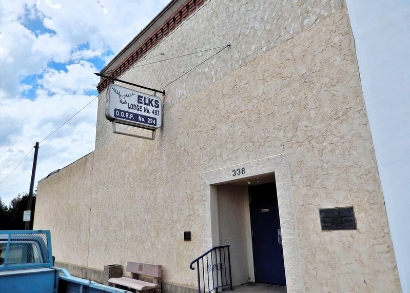
B.P.O.E. Bassano Lodge #487 Marker
1 ► Alberta, Newell County, Bassano — B.P.O.E. Bassano Lodge #487 —
On 2 Avenue just west of 3 Street East, on the right when traveling west.
This building is dedicated to the efforts of Bros. A. C. Hockett and the late John A. Jeffery, Grand Organizers, who instituted Bassano Lodge No. 487 September 21, 1964 — — Map (db m301619) HM
2 ► Alberta, Newell County, Bassano — Built in 1911 — Bassano Centennial 2011 —
On 2 Avenue at 3 Street East, on the right when traveling west on 2 Avenue.
1928 Flanagan Bros. Hardware 1976 Sam’s Place 1983 Cochrane Hardware — — Map (db m301907) HM
3 ► Alberta, Newell County, Bassano — Canadian Government Post Office — 1915-1988 — Bassano Centennial 2011 —
On 3 Street East at 3 Avenue, on the right when traveling north on 3 Street East.
1988 Private Apartments — — Map (db m301799) HM
4 ► Alberta, Newell County, Bassano — Central Meat Market — Built in 1910 — Bassano Centennial —
On 2 Avenue just east of 3 Street East, on the right when traveling east.
1941 Pioneer Meat Market 1973 Ed’s Meat Market 2006 Bassano Flower and Gift — — Map (db m301797) HM
5 ► Alberta, Newell County, Bassano — Crown Lumber Co. — Built in 1907 — Bassano Centennial 2011 —
On 2 Avenue just east of 3 Street East, on the left when traveling east.
1950 Dr. Mason 1963 MacKay Insurance 2004 Pro Insurance — — Map (db m301796) HM
6 ► Alberta, Newell County, Bassano — Hunter Hotel — Built in 1911 — Bassano Centennial 2011 —
On 2 Avenue at 4 Street, on the left when traveling west on 2 Avenue.
1930 Imperial Hotel 2007 Imperial Hunter Hotel — — Map (db m301834) HM
7 ► Alberta, Newell County, Bassano — Ingram Real Estate Block — Built in 1912 — Bassano Centennial 2011 —
On 2 Avenue just west of 3 Street East, on the right when traveling west.
1912 Quebec Bank 1930 Orpheum Theatre 1950 Capitol Theatre 1965 Benevolent and Protective Order of Elks — — Map (db m301200) HM
8 ► Alberta, Newell County, Bassano — Stiles “The Druggist” — Built in 1912 — Bassano Centennial 2011 —
On 2 Avenue just east of 3 Street East, on the right when traveling east.
1974 Bea’s Boutique 1978 Metcalf’s Fabrics & Bassano Flower Shop 1985 Joe’s Boot and Shoe Repair — — Map (db m301774) HM
Paid Advertisement
9 ► Alberta, Newell County, Bassano — Union Bank of Canada — Built in 1910 — Bassano Centennial 2011 —
On 2 Avenue just west of 3 Street East, on the right when traveling west.
1925 Royal Bank of Canada 1974 Town of Bassano — — Map (db m301712) HM
10 ► Alberta, Newell County, Bassano — Webster Bros. Gen. Merchants — Built in 1913 — Bassano Centennial 2011 —
On 2 Avenue just east of 3 Street East, on the right when traveling east.
1914 James Johnston Grocery 1947 M & M Grocery 1964 Macleod Hardware 1966 IEM Hardware — — Map (db m301798) HM
11 ► Alberta, Newell County, Brooks — Brooks Aqueduct — Eastern Irrigation District —
On Range Road 142 1.2 kilometers south of Township Road 184 (Provincial Highway 1A), on the right when traveling south.
This earth aqueduct was built under an agreement between the governments of Canada and Alberta. It replaces the original concrete flume, constructed in 1912-14 to carry irrigation water across the valley to the Patricia and Tilley areas. The new . . . — — Map (db m301889) HM
12 ► Alberta, Newell County, Brooks — Brooks Aqueduct / L'Aqueduc de Brooks — National Historic Civil Engineering Site / Site Historique National de Génie Civil — 1914-1979 —
On Range Road 142 1.2 kilometers south of Township Road 184 (Provincial Highway 1A), on the right when traveling south.
[English] A monument to the achievements of those civil engineers who developed irrigation in southern Alberta. [Français] Un monument en hommage aux ingénieurs civils qui ont . . . — — Map (db m301974) HM
13 ► Alberta, Newell County, Brooks — River in the Sky — The river runs … slowly —
On Range Road 142 0.4 kilometers south of Township Road 183A Road, on the right when traveling south.
Water flowed through the Brooks Aqueduct every year from 1915 until it was replaced in 1979. The engineers who built the Aqueduct planned a delivery rate of about 900 cubic feet (25 cu. m) of water per second. The Aqueduct never managed it. From the . . . — — Map (db m196947) HM
14 ► Alberta, Newell County, Brooks — River in the Sky — Over and under —
On Range Road 142 0.4 kilometers south of Township Road 183A Road, on the right when traveling south.
Getting the water in and out of the Aqueduct wasn't the only challenge. As it marched across the valley it would run smack into the CPR tracks. The Aqueduct as planned was not high enough for trains to go under it. And the construction required to . . . — — Map (db m196952) HM
15 ► Alberta, Newell County, Brooks — River in the Sky — The CPR bows out, the farmers bow in —
On Brooks Aqueduct trail 1.4 kilometers west of Range Road 142.
Many settlers in the Eastern Irrigation Section had a hard time in the 1920s and 1930s. Low grain prices, deteriorating soils from alkali seepage into fields, and inexperience with irrigation farming techniques were some of the problems. Even though . . . — — Map (db m196954) HM
16 ► Alberta, Newell County, Brooks — River in the Sky — Working on the shell: The joints —
On Brooks Aqueduct trail 1.4 kilometers west of Range Road 142.
1916 “On April 6 … a camp … was located at the aqueduct for the purpose of tightening and repacking the metal bands at six expansion joints, and also of putting on additional bands … Total cost $160.00.” 1917 “Work was started on . . . — — Map (db m196955) HM
17 ► Alberta, Newell County, Brooks — The Brooks Aqueduct/L’aqueduc de Brooks —
Near Range Road 142 0.4 kilometers south of Township Road 183A Road, on the right when traveling south.
[English] The CPR built this reinforced concrete aqueduct between 1912 and 1914. It was part of a large irrigation scheme using water diverted from the Bow River to transform 55,000 hectares east of Brooks from semi-arid rangeland to farmland . . . — — Map (db m196937) HM
Paid Advertisement
18 ► Alberta, Newell County, Brooks — The River Runs Dry — The River in the Sky comes down to earth —
On Range Road 142 0.4 kilometers south of Township Road 183A Road, on the right when traveling south.
“So he grabbed hold of a pick, he just kind of lifted it up a bit and then drove it right through, right through the bowl. Well, as the pick went through the bowl his hair stood straight up on end, I can assure . . . — — Map (db m196950) HM
19 ► Alberta, Newell County, Brooks — Welcome to the Brooks Aqueduct —
Near Range Road 142 0.4 kilometers Township Road 183A Road, on the right when traveling south.
In the early 1900s the Canadian Pacific Railroad began construction of a huge irrigation project in Alberta comprising over a million hectares (3 million acres). Part of this original block land grant to the railway is now known as the Eastern . . . — — Map (db m196941) HM
 
 
CeraNet Cloud Computing sponsors the Historical Marker Database.
This website earns income from purchases you make after using our links to Amazon.com. We appreciate your support.
Paid Advertisement
Nov. 10, 2026
