Near New York State Route 86 at Lakeview Terrace Lane, on the right when traveling west.
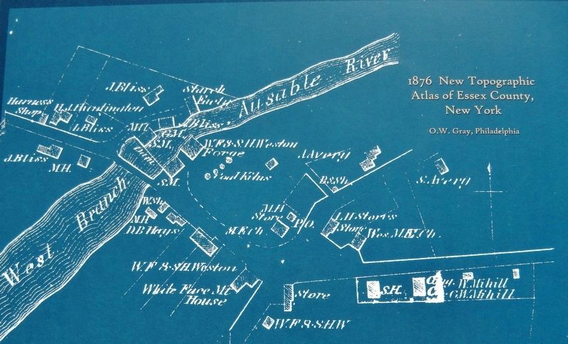
One of the first settlers, Reuben Sanford was an instrumental force in the development of Wilmington, building mills, an iron forge, stores and distilleries.
Even when travel to the Adirondacks involved many challenging miles by train and . . . — — Map (db m147455) HM
Near New York State Route 22 0.4 miles south of Burke Road.
Culver Hill, September 6, 1814. Near this spot fell Corporal Stephen Partridge of the Essex County New York State Militia, also Brevet Lieut. Colonel James Willington and Ensign John Chapman of the 3rd Foot British Army. — — Map (db m106395) HM
On Route 73 just north of Nature Way, on the right when traveling north.
Led Suffrage Campaign in the Adirondacks 1914-17. Former Summer home was HQ for Essex County Society of the New York State Women's Suffrage Assn. — — Map (db m238326) HM
On Lake Street at Ballantine Parkway, on the left when traveling north on Lake Street.
This is the oldest park in the first county park system established in the United States, and an outstanding example of naturalistic landscape design. The Essex County Park Commission, formed in 1895, acquired the first 60 acres from the City of . . . — — Map (db m44205) HM
On Lake Street at Ballantine Pkwy, on the left when traveling north on Lake Street.
This is the oldest park in the first county park system established in the United States, and an outstanding example of naturalistic landscape design. The Essex County Park Commission, formed in 1895, acquired the first 60 acres from the City of . . . — — Map (db m52169) HM
On New Jersey Route 23, on the right when traveling north.
The First Public Park Was an Urban Oasis When Europeans first arrived in America the land seemed limitless. However, by the late 1800s settlements stretched from the Atlantic to the Pacific. More people were living in crowded cities and needed . . . — — Map (db m24583) HM
On Creek Road (County Route 2) at Whitehead Road, on the left when traveling west on Creek Road.
The power of Putnam Creek drove the iron industry on its shores for over sixty years.
Although the structures disappeared nearly a century ago, many of the foundations remain visible today.
Follow the historic walking tour to discover the remains . . . — — Map (db m195856) HM
On Crest Drive south of Bear Lane, on the left when traveling south.
Preliminary Board 1894-1895
Permanent Board 1897-1900
A tribute to his successful efforts to secure the lands comprised in South Mountain Reservation for the healthful recreation of the people of Essex County.
Erected 1926 — — Map (db m212887) HM
On Front Street at W Upas Street, on the left when traveling north on Front Street.
In 1924, San Diego socialites and patrons of the arts, Miss Alice Lee and her partner, Miss Katherine Teats, commissioned renowned architect Louis Gill to build this historic home. Gill's design for a distinctive “Canyon House” features interior . . . — — Map (db m312270) HM
On Upper Works Road (County Route 25) 9.7 miles north of Blue Ridge Road, on the right when traveling north.
Original Owner: E. Holloway Coe
In 1916 Walter D. Edmonds, author of Drums Along the Mohawk, occupied this building. Later Club Era occupants were Thomas Williams, and Morris Douw Ferris.
Historical information is from "Documentation . . . — — Map (db m147779) HM
On Upper Works Road (County Route 25) 9.8 miles north of Blue Ridge Road, on the right when traveling north.
Original Owner: Walter Jennings
The only cottage built on the east shore of the Hudson, the cottage was accessed by a footbridge across the river, the abutments are still visible on the river banks.
Later Club Era occupants were Marshall . . . — — Map (db m147429) HM
On Main Street at North Lane, on the right when traveling east on Main Street.
Originally called Potopaug by local Indians, Essex was named after England’s Essex County, whence some of its early settlers had come. As a part of Saybrook colony, the Essex area was first settled in 1648 by John Lay, William Pratt, and William . . . — — Map (db m65666) HM
On Santanoni Drive at Route 28N, on the left when traveling north on Santanoni Drive. Reported missing.
The town of Newcomb, in the geographical center of the Adirondack Park, was originally a part of the hunting grounds of the Iroquois and Algonquins. The first permanent European settlers arrived in 1816. Prominent among the earliest citizens were . . . — — Map (db m147513) HM
On Park Place (New York State Route 9N/22) east of Main Street ( Route 9N/22), on the left when traveling east.
The Civil War's monstrous appetite for iron - for horse shoes, artillery, cannon balls, rifles, and armor plate - exposed the greatest obstacle to iron production in Moriah: getting ore from the mines to the lake shore. Even 100 teams of horses . . . — — Map (db m109033) HM
On Upper Works Road (County Route 25) 9.7 miles north of Blue Ridge Road, on the right.
Original Owner: William F. King
In 1935 this cottage, nicknamed 'Lazy Lodge' was occupied by the wife of W.R.K. Taylor, Sr. Mrs. Taylor may have been the mother of W.R.K Taylor, Jr., who occupied the next cottage to the north. Alexander . . . — — Map (db m147906) HM
On Upper Works Road (County Route 25) 9.7 miles north of Blue Ridge Road, on the left when traveling north.
Original Owner: Tahawus Club
Built in 1847 as a boarding house and remodeled in 1877 to be the Adirondack (Tahawus) Club House. For a time during the Club Era, fish rearing tanks for 100,000 fry
were housed in the rear wing. The deteriorated . . . — — Map (db m147441) HM
On Upper Works Road (County Route 25) 9.7 miles north of Blue Ridge Road, on the right when traveling north.
Original Owner: W.R.K. Taylor Jr.
Built in 1932, Taylor was a third generation resident of the Tahawus Club
community, his father was W.R.K. Taylor, Sr., and his grandfather was
Alexander Taylor. The cottage housed two independent living . . . — — Map (db m147907) HM
On Upper Works Road (County Route 25) 9.7 miles north of Blue Ridge Road, on the right when traveling north.
Original Owner: Gordon Abbott
Built shortly after formation of the Tahawus Club. Later occupants were
Marshall Geer, and Acosta Nichols. The final owner during the Club Era
was William A. Lockwood.
Historical information is from . . . — — Map (db m147866) HM
On Brooke Road 0.1 miles west of Chandlee Mill Road, on the right when traveling west.
Lineage of Leatha Howard Holland Webster and the Canadian Connection
The Howard-Holland traces its roots to the Montgomery County plantations of the Gaithers, Howse and Griffith families. From census records and manumission . . . — — Map (db m188339) HM
CIVIL WAR
Frederick Alber · Army · Germany
Frank Dwight Baldwin · Army · Manchester, MI
Frederick A. Ballen · Army · Germany
Charles L. Barrell · Army · Conquest, NY
Joseph E. Brandle · Army · Seneca Co. OH
James Isaac Christianey . . . — — Map (db m236267) WM
On Skinner Butte Loop, on the left when traveling north. Reported missing.
Early settler of this region for whom the city of Eugene and Skinner Butte is named. According to tradition, Skinner built the area’s first cabin near this site, ca 1846. — — Map (db m264844) HM
Thin black lines indicate changes in relevance. Between each pair of lines entries are ordered geographically but all have the same relevance.
* Inflectional forms of words are their plurals, singulars, and possessives as well as gramatical tenses and similar variations.