In memory of
Citizens of Osceola
murdered by Kansas
Jayhawkers
and the Union Army
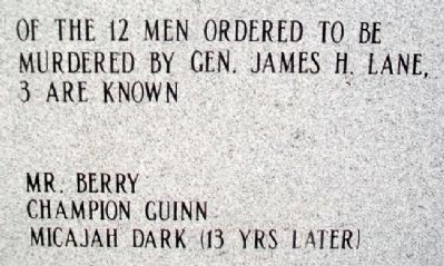
Of the 12 men ordered to be
murdered by Gen. James H. Lane,
3 are known
Mr. Berry • Champion Guinn
Micajah Dark (13 yrs later)
In June 1861, . . . — — Map (db m61518) HM
On 2nd Street (State Highway WW) at Pine Street, on the right when traveling north on 2nd Street.
Early thriving Osage River post. Osceola was settled during the mid-1830's largely by Southerners. The settlement and its first store were known as the "crossing of the Osage at Crow and Crutchfield's," until the name of the Indian warrior was . . . — — Map (db m36090) HM
On Main Street near Cherry Street, on the right when traveling north.
Nevada City was laid out as Vernon County's seat of government in 1855, and was named for a California town prominent during the Gold Rush. Founding spirit DeWitt C. Hunter had spent some years mining there before returning to western Missouri . . . — — Map (db m34210) HM
On Kaskaskia Street (County Road 6) at Shaweeneetown Trail (County Road 3), on the right when traveling west on Kaskaskia Street.
This region lowered the French Bourbon flag in October 1765 when the territory fell under British control. A British military report commissioned a few years later states that the French redoubt here called Fort Kaskaskia had been burned and . . . — — Map (db m302431) HM
On Levee Road 3.3 miles south of Roots Road, on the left when traveling south.
Mississippi River Flooding and the Demise of Old Kaskaskia
Kaskaskia Village was the Randolph County seat of government from 1795 until 1844 when a massive flood extensively damaged the village, and the county seat was moved to Chester. . . . — — Map (db m257360) HM
Route 66, the Mother Road, is an American icon that symbolizes romance and freedom of the open road. Born in 1926, Route 66 was one of the first numbered U.S. highways, journeying 2,500 miles from Chicago to Los Angeles. Today, you can still "get . . . — — Map (db m144521) HM
On West 6th Street just east of North Maple Street (State Highway KK), on the left when traveling east.
In 1868, William Milton Prier was the owner of 520 acres of land which would become Appleton City. In 1870 when the Railroad came through this area, he sold most of his holdings for land development. However, he retained this site in Block 36 . . . — — Map (db m181430) HM
On Grand Avenue at Pine Street, on the left when traveling south on Grand Avenue.
This bell has been donated by the Rock School District of Cedar County Missouri in commemoration of the former Common School Districts which presently comprise the El Dorado Springs R-2 School District.
Cedar County
Barnes • Cedar Springs . . . — — Map (db m57417) HM
Thin black lines indicate changes in relevance. Between each pair of lines entries are ordered geographically but all have the same relevance.
* Inflectional forms of words are their plurals, singulars, and possessives as well as gramatical tenses and similar variations.