On Pier Road at Riverview Drive, on the right when traveling west on Pier Road.
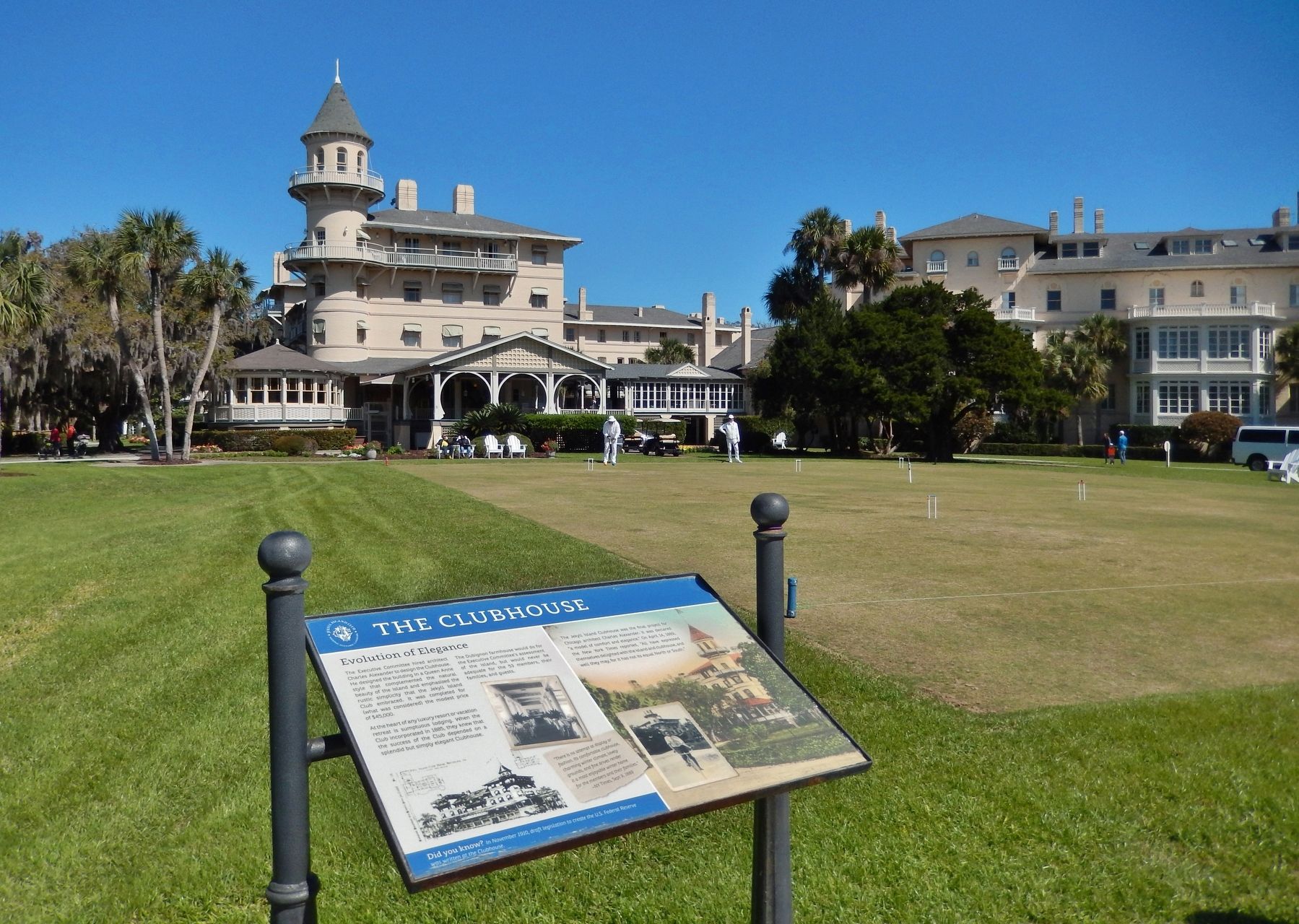
The Executive Committee hired architect Charles Alexander to design the Clubhouse. He designed the building in a Queen Anne style that complemented the natural beauty of the island and emphasized the rustic simplicity that the Jekyll Island Club . . . — — Map (db m115117) HM
Near Pier Road east of Riverview Drive, on the right when traveling north.
The brick outline that you see in front of you marks the former Location of Fairbank Cottage.
When Chicago manufacturer Nathaniel Kellogg Fairbank purchased the lot in 1889, he was excited about the possibilities of his new cottage. Fairbank . . . — — Map (db m115121) HM
On Old Plantation Road at Pier Road, on the right when traveling north on Old Plantation Road.
By 1905, tennis was gaining popularity on the island over hunting. Robert Pruyn, chairman of the committee on golf and sports, said, "For two years, tennis has been the most popular outdoor sport," and requested additional courts to be . . . — — Map (db m115118) HM
On Old Plantation Road north of Schoolhouse Lane, on the right when traveling north.
Chartered by the State of Georgia to be trustworthy stewards of the island, the Jekyll Island Authority has been very active in the preservation of the National Historic Landmark District. The rehabilitation of Crane Cottage and Cherokee in . . . — — Map (db m115119) HM
Near Riverview Drive just north of Pier Road, on the left when traveling north.
They came by water. Long before the present-day causeway was built, the only way to reach Jekyll Island was by boat. Large steam-powered vessels from the North, such as the Mallory Steamship Line, delivered Club staff and sundry personal items . . . — — Map (db m227718) HM
On Riverview Drive, 0.2 miles south of Stable Road, on the left when traveling south.
With a wife and nine children, Charles Stewart Maurice quickly decided accommodations at the Clubhouse would not suffice. In 1890, he built Hollybourne as a home away from home for their winter stays here on the island. Maurice was a bridge . . . — — Map (db m227671) HM
On Pier Road east of Hopkins Avenue, on the right when traveling east. Reported missing.
Under the original
landscape plan, 50 plots of land were laid out around the Clubhouse in a very community-oriented fashion. However, not all of the members chose to build their own cottages on these plots.
Over the years a thriving . . . — — Map (db m234944) HM
On Pier Road east of Hopkins Avenue, on the right when traveling east.
The corridor of Pier Road was not only the hub of service for the Jekyll Island Club, it was also the heart of the community for countless employees.
Yes, here you would find a taxidermy shop, upholstery shop, coal storage, woodsheds and . . . — — Map (db m115093) HM
On Old Plantation Road west of Stable Road, on the right when traveling west.
On the Move
When first constructed in 1890, Furness Cottage stood as a lone sentry in the southern portion of the Club compound.
The growing popularity of cottage construction led to its first move, off of Riverview Drive.
. . . — — Map (db m115114) HM
On Riverview Drive, 0.2 miles north of Stable Road, on the right when traveling north.
With only drive and ambition, Frank Henry Goodyear rose from a $35-per-month bookkeeper to the head of a vast lumber, coal, iron, and railroad empire.
Far from viewing Jekyll Island as a place to escape the stresses of business, Goodyear took . . . — — Map (db m115120) HM
The Czar of Jekyll Island
What to do when you require privacy from the overflowing crowds of guests at the Clubhouse, but want to take advantage of its world-class French chef, new billiards wing, and the cheerful fireplace of the main . . . — — Map (db m155904) HM
On Pier Road, 0.5 miles east of Old Plantation Road, on the right when traveling west.
The Skeet House is not in its original location, but stands as a symbol of the core philosophy that the Jekyll Island Club was founded upon – outdoor recreation.
The Skeet House, along with the Skeet and Trap Range, was constructed in . . . — — Map (db m234943) HM
On Old Plantation Road south of Pier Road, on the right when traveling south.
Constructed in 1896, this structure housed the steamplant that provided heat in the Sans Souci apartments. The actual components were housed in a concrete basement and the steam passed through underground piping. This photograph was taken from the . . . — — Map (db m164474) HM
Near James Road, 0.1 miles north of Hopkins Avenue, on the right when traveling north.
Horses, carriages, livery, and tack were all integral to the leisurely horseback rides and peaceful carriage drives enjoyed by Jekyll Island Club members. Many members brought their own supply of horses and carriages along with the coachmen and . . . — — Map (db m227643) HM
On Pier Road just west of Stable Road, on the right when traveling west.
It required an array of workers and a dedicated attention to detail to provide the superior service and Life of Luxury expected by the members of the Jekyll Island Club. The Club bookkeeper served an essential role in fulfilling those expectations . . . — — Map (db m227733) HM
On Stable Road just south of Pier Road, on the left when traveling south.
From the beginning of the Jekyll Island Club, members realized they would need stables on the island for the use of its members and staff. In 1887, landscape architect H.W.S. Cleveland suggested plans for a stable to be located behind the . . . — — Map (db m227653) HM
On Great Dunes Lane, 0.1 miles north of Shell Road.
In 1897, the game of golf was listed among a variety of outdoor recreations and improvements planned to entertain "the younger set" at the Jekyll Island Club. The game continued to gain popularity on the island throughout the 1910s. Because . . . — — Map (db m227721) HM