On Fort Yargo Road, 0.2 miles east of South Broad Street (State Highway 81), on the left when traveling south.
Between the Oconee & Ocmulgee In the late 1700s, the (Muscogee) Creek village of Snoden, present-day Winder, was located within the unbroken forests of Georgia's wilderness. Numerous waterways crisscrossed the landscape supplying . . . — — Map (db m187100) HM
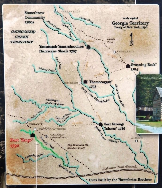
Near Fort Yargo Road east of South Broad Street (Georgia Highway 81), on the left when traveling south.
Small forts sprang up across Georgia's Indian lands during and after the Revolutionary War. The Creek, Cherokee, and other native peoples were drawn into the conflict by the British and fought skirmishes against the settlers who were establishing . . . — — Map (db m187300) HM
Near Fort Yargo Road east of South Broad Street (Georgia Highway 81), on the left when traveling south.
Fort Yargo benefits from a group of volunteer living historians who assist in maintaining the original 1790s blockhouse structure, as well as providing demonstrations of the lifeways and skills of the late 18th and very early 19th centuries. The . . . — — Map (db m187354) HM
Near Fort Yargo Road east of South Broad Street (Georgia Highway 81), on the left when traveling south.
Settlers established farms as they arrived in new areas. They cleared forest and brush and built fences to corral their livestock, to mark their boundaries, and to keep out predators. The type of fence they built depended on available materials and . . . — — Map (db m187366) HM
Near Fort Yargo Road east of South Broad Street (Georgia Highway 81), on the left when traveling south.
Imagine this log building being occupied by 30 to 50 people while under attack by Indians. That was its purpose when it was built in 1792. Settlers in the area took refuge in the fort during times of threat or attack. When it was not being used for . . . — — Map (db m187377) HM
Near Fort Yargo Road east of South Broad Street (Georgia Highway 81), on the left when traveling south.
Fort Yargo resembles many log cabins built across the southern highlands, especially those of Appalachia. It is one and one-half stories, with front and back doors opposite to each other for air flow during the warmer months. It has a shake roof . . . — — Map (db m187400) HM
Near Fort Yargo Road east of South Broad Street (Georgia Highway 81), on the left when traveling south.
At one time, settlers used beehive ovens to bake all kinds of foods. Taking its name from its shape, the beehive oven can be found in all parts of the world even today. They are simple to build from clay and straw so there is little or no cost — . . . — — Map (db m187401) HM
Near Fort Yargo Road east of South Broad Street (Georgia Highway 81), on the left when traveling south.
Fort Yargo's smokehouse is a reconstruction and is in use most winters. Smokehouses served to cure meat or fish with smoke and salt. Before the invention of refrigeration, fresh meat would not last very long unless it was "smoked" or frozen. In the . . . — — Map (db m187402) HM
On Fort Yargo Road, 1 mile south of Loganville Highway (Georgia Highway 81), on the right when traveling south.
In Memory of Charles O. Maddox 1887 – 1973 Banker, Farmer, Conservationist Purchased and held for 18 years 1800 acres of land In 1954 he transferred the land to the State of Georgia at no personal gain His vision was then fulfilled . . . — — Map (db m187403) HM
On Broad Street, 0.4 miles south of South Broad Street (Georgia Route 81), on the left when traveling south.
This remarkably preserved log blockhouse was built in 1793, according to historians. There are several references to Fort Yargo as existing prior to 1800. Its location is given as three miles southwest of “Jug Tavern,” original name for Winder. . . . — — Map (db m22396) HM
On Fort Yargo Road, 1 mile south of Loganville Highway (Georgia Highway 81), on the right when traveling south.
Built under the Watershed Protection and Flood Prevention Act 83rd Congress — 1954 by Barrow County, Georgia Oconee River Soil and Water Conservation District City Government of Winder Department of State Parks of Georgia with assistance . . . — — Map (db m173170) HM