Near 8th Street Southwest just west of State Highway 200, on the left when traveling west.
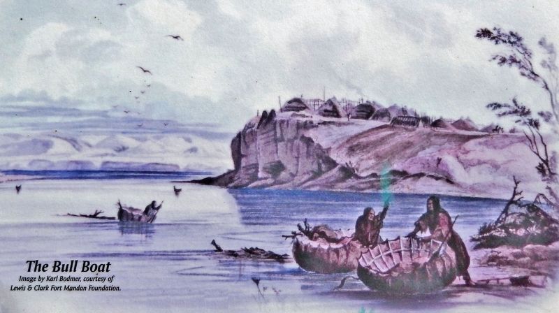
One of the earliest forms of Missouri River transportation was the bull boat. Used primarily by the Mandan, Hidatsa, and Arikara tribes, bull boats served as the main watercraft for natives living along the river banks. These boats were both built . . . — — Map (db m235041) HM
Near State Highway 200, 0.5 miles south of 8th Street Southwest (Border Lane), on the right when traveling south.
In the early 1920s, most North Dakota towns were served by small local power plants producing direct current (DC) electric power. In 1926, Otter Tail Power Company of Fergus Falls, Minnesota, was one of several companies building a series of power . . . — — Map (db m235057) HM
Near Boat Ramp Road just south of Lewis and Clark Trail (1st Street), on the right when traveling south.
Nettle Creek School was the first school in McLean County, opening on November 6, 1883. Originally located seven miles east of Washburn, the one-room country school was first constructed as a log cabin, with clapboard siding added to it later. In . . . — — Map (db m235060) HM
The bridging of the Missouri River at Washburn had been a longtime goal for residents of the community. As early as 1908, a party of local residents traveled to Washington, D.C., unsuccessfully, in the interests of such a project. During the 1920s . . . — — Map (db m235047) HM
On Boat Ramp Road just west of 1st Avenue, on the left when traveling west.
To attract shoppers to Washburn from west of the Missouri River, the Washburn Road installed a cable ferry in May 1902, known unofficially as the General Washburn. Cable ferries were small, unpowered boats attached to steel cables stretched between . . . — — Map (db m235089) HM
On Boat Ramp Road just west of 1st Avenue, on the left when traveling west.
In 1950 Oscar Anderson, a native of Washburn who had traveled the world since 1917 as an officer in the merchant marine, returned home to spend his retirement years. He found a community that missed its ferryboat connection with the west bank of . . . — — Map (db m235095) HM
On Boat Ramp Road just west of 1st Avenue, on the left when traveling west.
The last stern wheel ferry on the Missouri. Built by Oscar Anderson in 1951 and operated by him on the Missouri River at Washburn from 1952 to 1962. Restored by the Washburn Bi-centennial Committee in 1976. American Revolution Bicentennial . . . — — Map (db m235096) HM
Near 8th Street at 1st Avenue when traveling south.
The first steamboat to reach the upper Missouri was the American Fur Company's Yellow Stone, which arrived at Fort Union in 1832. Nearly 30 years later, steamers began reaching Fort Benton, Montana, the head of navigation on the Missouri. From then . . . — — Map (db m235097) HM
Near 8th Street at 1st Avenue when traveling south.
In 1898, William Drew Washburn, a wealthy Minneapolis flour miller, railroad man, and U.S. Senator from Minnesota, purchased 115,000 acres of land along the line between McLean and Burleigh counties. He formed the Bismarck, Washburn & Great Falls . . . — — Map (db m235098) HM