On East Douglas Street (U.S. 62), on the right when traveling west on East Douglas Street.
The battle on this field was fought between the Confederate army of General T.C. Hindman (Arkansas) and Federal forces commanded by Generals James G. Blunt (Kansas) and F.J. Herron (Iowa). Battlefield Park occupies the approximate center of the . . . — — Map (db m35248) HM
On East Douglas Street (U.S. 62), on the right when traveling west.
(Upper Plaque):This property has been placed on the National Register of Historic Places by the United States Department of the Interior (Lower Plaque): Hindman Hall Museum At bequest by Biscoe Hindman, son of General Thomas C. Hindman . . . — — Map (db m35253) HM
On East Douglas Street (U.S. 62), on the right when traveling west.
General Hindman on the Arkansas River planned to drive General Blunt's Federal army out of northwest Arkansas. The Confederate army left Van Buren on December 3. Enroute north, Hindman learned that Blunt had called for help from General Herron at . . . — — Map (db m35255) HM
On East Douglas Street (U.S. 62), on the right when traveling west.
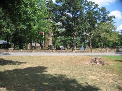
The original 10 acres of Battlefield Park were purchased in 1908 by the Prairie Grove chapter of the United Daughters of the Confederacy and maintained by the U.D.C. for nearly 50 years as a memorial park. From 1886 to 1926 an annual reunion of . . . — — Map (db m35272) HM
On East Douglas Street (U.S. 62), on the right when traveling west.
Thomas C. Hindman commanded the Confederate army in the battle of Prairie Grove. He was born 1828 in Tennessee. Served in the War with Mexico, later moving from Mississippi to Helena, Ark. Was elected to Congress in 1859. In 1861 he entered the . . . — — Map (db m35275) HM
On East Douglas Street (U.S. 62), on the right when traveling west.
This tower was the chimney of Rhea's Mill, which stood 6 miles northwest of this spot. The mill was operated by the Federal army before and after the battle of Prairie Grove. General Blunt's supply train was at Rhea's during the battle, under guard . . . — — Map (db m35276) HM
On East Douglas Street (U.S. 62), on the right when traveling west.
General James G. Blunt General Blunt of Kansas commanded the First Division of the Federal army in the battle of Prairie Grove. He was made Brigadier General in April 1862 and given command of all Kansas troops. His army was at Cane Hill . . . — — Map (db m35277) HM
On South Battlefield Park Road (County Route 80) at East Douglas Street (U.S. 62), on the right when traveling north on South Battlefield Park Road.
From this spot the observer is viewing the terrain over which General James G. Blunt's 1st Division advanced on the afternoon of December 7, 1862, to attack the Confederate left and relieve the pressure on General F. J. Herron's 2nd and 3rd . . . — — Map (db m35329) HM
On South Battlefield Park Road (County Route 80) at East Douglas Street (U.S. 62), on the right when traveling north on South Battlefield Park Road.
During the Battle of Prairie Grove Gen. Robt. G. Shaver established his head- quarters under this tree Dec. 7, 1862 This spot marked by U.D.C. June 20, 1932. — — Map (db m35332) HM
On East Douglas Street (U.S. 62), on the right when traveling west.
The circular stone wall that encloses the Battle Monument is built of stones from historic structures of Washington County. Some 40 communities are represented, including the pioneer settlements at Cane Hill, Cincinnati, Viney Grove, Rhea's Mill, . . . — — Map (db m35360) HM
Near East Douglas Street (U.S. 62), on the right when traveling west.
This house, built about 1855, was the home of the John Morrow family, and originally stood on Cove Creek 9 miles south of here. On the night before the battle of Prairie Grove, Confederate General T.C. Hindman met with his division and brigade . . . — — Map (db m35361) HM
Near East Douglas Street (U.S. 62), on the right when traveling west.
This 2-story log house and out-buildings were erected by John Latta about 1834 on Evansville Creek, 12 miles southwest of this spot. The Latta settlement was called Vineyard from "The Lord's Vineyard." Vineyard was the first postoffice in Washington . . . — — Map (db m35363) HM
Near Park Tour Road, on the right when traveling east.
The heaviest casualties were around the Archibald Borden house and orchard. The first house was burned the day after the battle. Mr. Borden built this house on the site of the original in 1872. Charles W. Walker, 34th Arkansas Infantry, recalled: . . . — — Map (db m35365) HM
Near Park Tour Road, on the right when traveling east.
Blocher's Arkansas Battery was the focal point of the Union attacks. A sergeant in the battery reported: "...The enemy advanced upon us with their artillery, under cover of their infantry, until within range of our battery when they opened a most . . . — — Map (db m35411) HM
Near Park Tour Road, on the right when traveling east.
From this spot the observer is viewing the fields over which General F.J. Herron's army advanced on the morning of December 7, 1862, to attack the Confederate position on this ridge. Because the ford of the Illinois River was under artillery fire, . . . — — Map (db m35415) HM
Near Park Tour Road, on the right when traveling east.
The men who died on this field on December 7, 1862 are buried in the soldier cemeteries in Fayetteville. 700 unknown Confederate soldiers are in the cemetery maintained by the Southern Memorial Association on East Mountain. The Union dead are in the . . . — — Map (db m35416) HM
Near Park Tour Road, on the right when traveling east.
The 26th Indiana Infantry and the 37th Illinois Infantry made another attack up the ridge. Colonel John G. Clark, 26th Indiana, U.S.A., wrote: "The regiment was ... ordered on the left of the 37th Illinois...Soon after...they were ordered to . . . — — Map (db m35421) HM
Near Park Tour Road, on the right when traveling east.
Lieutenant Colonel John C. Black, 37th Illinois Infantry, ordered the retreat of his regiment and the 26th Indiana to a fence at the foot of the ridge. There, the men faced a Confederate counterattack. Captain William P. Black, brother of Lieutenant . . . — — Map (db m35423) HM
Near Park Tour Road, on the right when traveling east.
Brothers Columbus and Ad Gray of Company D, 29th Arkansas Infantry, withstood the first Union assault and counterattacked with Sergeant Ad Gray in the lead. Columbus Gray wrote home after seeing his brother fall mortally wounded: "I stopped, . . . — — Map (db m35430) HM
On North Mock Street (County Road 652) at Collins Drive, on the right when traveling north on North Mock Street.
(Panels from Left to Right) (First Panel): At the time of the battle, Nancy Morton lived with her parents in the William Morton house west of this location. When the fighting intensified in the area, the Mortons and three other families . . . — — Map (db m35434) HM
On West Buchanan Street (U.S. 62) at Katie Smith Street, on the right when traveling west on West Buchanan Street.
Site of the first Cumberland Presbyterian Church. Used as a hospital during the battle of Prairie Grove 1862 marked by Prairie Grove Chapter U.D.C. 1930. — — Map (db m88394) HM