The first international bridge built near the falls was known as the Upper Suspension or New Suspension Bridge. When it was opened in 1869 with a 1,260-foot (384-meter) span, it was the longest suspension bridge ever constructed. The bridge was . . . — — Map (db m71524) HM
A Bridge to Freedom "There was now but 'one wide river to cross'..." In the 1800s, Western New York was one of the main ending points of the Underground Railroad. This "railroad" was a secret system of people and places that helped . . . — — Map (db m93027) HM
United States Custom House has been placed on the National Register of Historic Places in 1973 by the United States Department of the Interior — — Map (db m159971) HM
Bridge Ruins Second Lewiston-Queenston bridge, 1899-1962, carried seasonal tourist trolleys across gorge, forming the Great Gorge Belt Line. — — Map (db m154543) HM
This tollhouse was part of the Lewiston-Queenston Suspension Bridge which spanned the Lower Niagara River at the foot of the Niagara Escarpment near today’s Artpark.
Historic Lewiston Bridge Linked U.S. with Canada
After the first . . . — — Map (db m189520) HM
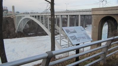
The Rainbow Bridge, owned and operated by the Niagara Falls Bridge Commission, was built in 1940-41 to replace the Upper Steel Arch Bridge. Its abutments are 15.1m (50 ft.) above the level of river ice jams. When it was built its 286m (950 ft.) arch . . . — — Map (db m64661) HM
The adjacent stone monument commemorates the visit of their majesties King George VI and Queen Elizabeth to view the site of the Rainbow Bridge on June 7, 1939.
Originally laid at the base of the carillon tower, it was severely damaged by an . . . — — Map (db m115417) HM
An abutment of the Upper Steel Arch Bridge built on this site 1897-98, is visible on the U.S. shore of the river. Also known as the Falls View Bridge and the Honeymoon Bridge, it stood until January 27, 1938, when an ice jam pushed the bridge off . . . — — Map (db m79521) HM
This plaque marks the entrance to the Upper Suspension Bridge, opened in July 1869, then the longest suspension bridge in the world. The iron cables were hung from timber towers. In 1884-87, this wooden bridge was changed to steel. In 1898, this . . . — — Map (db m64670) HM