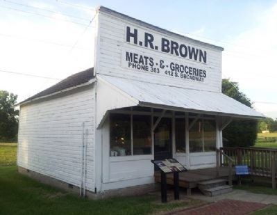
H.R. Browns Grocery was one of the last neighborhood grocery stores in Pittsburg, Kansas. By 1912, there were seventy-nine retail grocery stores in Pittsburg. Their strength was in their relative convenience for their customers. Regular customers . . . — — Map (db m312174) HM
The women’s march of 1921 epitomizes the spirit of the Kansas Balkans, an area known for its rich cultural heritage and turbulent strike-ridden history. On December 12 of that year, 3,000 (by some reports up to 6,000) women—wives and other . . . — — Map (db m35692) HM
The Osage at Baxter Springs
The Osage once controlled a vast territory in the center of North America. In the mid-1600s, the tribe moved to the area around Baxter Springs. The area was important to the Osage because, for the tribe, it was . . . — — Map (db m174252) HM
With the discovery of coal in Cherokee and Crawford Counties in the late 1860's, thousands came to work the mines. Some came from American towns and cities but most were immigrants from Europe. Over fifty nationalities settled in this area. Many . . . — — Map (db m39738) HM
[Honor Roll of Names on Black Granite]
April 15, 1995
This UH-1H "Huey" helicopter was donated by Department of the Army and Kansas Army National Guard to Girard Veterans of Foreign Wars Post 7479 through the efforts of All American Post . . . — — Map (db m36946) HM WM
Baxter Springs was named for John Baxter, the area's first European settler in 1849, and the springs on his homestead. A military surveying party who camped in the area in 1857 recounted springs rich in iron salts as rising in a "cone of red mud," . . . — — Map (db m174251) HM
Listed on the National Register of Historic Places by the United States Department of the Interior March 16, 2007 and on the Kansas Register of Historic Places November 18, 2006
Constructed in 1936 with federal funding assistance, the Franklin . . . — — Map (db m314715) HM
Among the many significant European immigrants in Kansas history is Alexander Howat, President of District 14 of the United Mine Workers of America. He was chiefly responsible for the organization of a powerful and militant union membership in the . . . — — Map (db m35668) HM
With the discovery of coal in Cherokee and Crawford Counties in the late 1860's, thousands came to work the mines. Some came from American towns and cities but most were immigrants from Europe. Over fifty nationalities settled in this area. Many . . . — — Map (db m35522) HM
The people of the Cherokee Nation left a lasting legacy to this corner of the State.
The 1836 Treaty of New Echota forced the removal of the Cherokee Nation from lands east of the Mississippi to the new Indian Territory. In addition to the . . . — — Map (db m81141) HM
• William Wilkinson was born in Pelton Fell, England in 1862. He worked in the mines from the age of 10 and came to Weir City, Kansas, in 1883 at the age of 20 to continue mining.
• In 1917, he started his own deep mine a mile south of . . . — — Map (db m35606) HM
Dr. Charles H. Strong was a native of Girard, Pennsylvania.
Dr. Strong's dream came true when he decided to go deer hunting and possibly locate the geographical center of Crawford County, which had just been established in Southeast Kansas . . . — — Map (db m36928) HM
Green Elm School was a one-room school house built in the 1870's in southeast Kansas. It was located in the southwest corner of Crawford County, seven miles north and one mile west of McCune, Kansas. The school held classes 1872-1955 and employed . . . — — Map (db m84737) HM
History
Company 788, CCC, was formed at Camp Whiteside, Fort Riley, Kansas, May 19, 1933. The company was made up of Kansas boys, the largest percentage coming from the eastern part of the state.
After conditioning at Fort Riley, the . . . — — Map (db m50189) HM
Frontenac, Kansas first came into being when the coal mining industry moved into the area during the late 1800s. The Santa Fe Railroad leased the land around what is present-day Frontenac, and formed the Cherokee and Pittsburg Coal and Mining . . . — — Map (db m35604) HM
Phase One: Pioneer Mining
The coal fields of Cherokee and Crawford Counties covered over 300 square miles of land, making it a prime area for coal mining. When early settlers first moved into the area in the 1800's, they were amazed to see . . . — — Map (db m35571) HM
A.W. Beck was responsible for the development of the buildings on east Madison from Jefferson to South Avenues (viewed on the other side of this sign). Mr. Beck was an instrumental business leader from 1870 to 1928. He brought many new ideas and . . . — — Map (db m83701) HM
owned and operated the Pritchett Insurance and Real Estate Agency in Pittsburg, Ks. for more than 50 years.
This park is one of the results of a trust they established with a mission to improve the quality of life in Pittsburg and Crawford . . . — — Map (db m36831) HM
In September, 1875, members of the Masonic fraternity proposed the establishment of a lodge in Lake City. Twenty Masons, who felt themselves to be sufficiently permanent residents to affiliate with a local lodge, met on December 4, 1875. To provide . . . — — Map (db m292097) HM
This active and restored railroad depot, completed
around 1902 by the Frisco Railroad Company, stands
as a living memorial to the entrepreneurial spirit and
the great periods of commerce that railroads brought
to our city.
As early as . . . — — Map (db m243970) HM
Thin black lines indicate changes in relevance. Between each pair of lines entries are ordered geographically but all have the same relevance.
* Inflectional forms of words are their plurals, singulars, and possessives as well as gramatical tenses and similar variations.