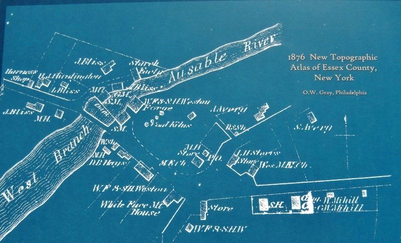
By O.W. Gray, Philadelphia
Marker detail: 1876 New Topographic Atlas of Essex County, New York
RANKED BY RELEVANCE
| Near New York State Route 86 at Lakeview Terrace Lane, on the right when traveling west. |
| On Main Street (New York State Route 22) 0.2 miles south of South Library Street, on the right when traveling south. |
| Near New York State Route 22 0.4 miles south of Burke Road. |
| On Route 73 just north of Nature Way, on the right when traveling north. |
| On Main Street (Pennsylvania Route 487) south of Broad Street, on the right when traveling north. |
| On Lake Street at Ballantine Parkway, on the left when traveling north on Lake Street. |
| On Lake Street at Ballantine Pkwy, on the left when traveling north on Lake Street. |
| On Park Place east of Main Street (New York State Route 9N/22), on the left when traveling east. |
| On New Jersey Route 23, on the right when traveling north. |
| On Creek Road (County Route 2) at Whitehead Road, on the left when traveling west on Creek Road. |
| On Crest Drive south of Bear Lane, on the left when traveling south. |
| On Front Street at W Upas Street, on the left when traveling north on Front Street. |
| On Essex Road (New York State Route 22) 0.8 miles south of Middle Road (County Road 22M), on the right when traveling north. |
| On Upper Works Road (County Route 25) 9.7 miles north of Blue Ridge Road, on the right when traveling north. |
| On Upper Works Road (County Route 25) 9.8 miles north of Blue Ridge Road, on the right when traveling north. |
| On Main Street at North Lane, on the right when traveling east on Main Street. |
| On Santanoni Drive at Route 28N, on the left when traveling north on Santanoni Drive. Reported missing. |
| On Park Place (New York State Route 9N/22) east of Main Street ( Route 9N/22), on the left when traveling east. |
| On Upper Works Road (County Route 25) 9.7 miles north of Blue Ridge Road, on the right. |
| On Upper Works Road (County Route 25) 9.7 miles north of Blue Ridge Road, on the left when traveling north. |
| On Upper Works Road (County Route 25) 9.7 miles north of Blue Ridge Road, on the right when traveling north. |
| On Upper Works Road (County Route 25) 9.7 miles north of Blue Ridge Road, on the right when traveling north. |
| On Brooke Road 0.1 miles west of Chandlee Mill Road, on the right when traveling west. |
| On Skinner Butte Loop, on the left when traveling north. Reported missing. |
Thin black lines indicate changes in relevance. Between each pair of lines entries are ordered geographically but all have the same relevance.* Inflectional forms of words are their plurals, singulars, and possessives as well as gramatical tenses and similar variations.
Nov. 12, 2026
