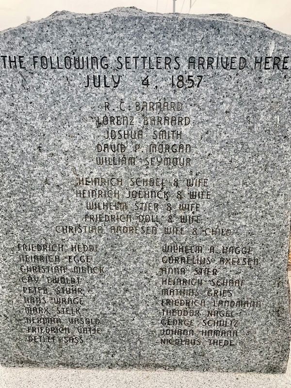
The following settlers arrived here July 4, 1857
R.C. Barnard
Lorenz Barnard
Joshua Smith
David P. Morgan
William Seymour
Heinrich Schoel & Wife
Heinrich Joehnck & Wife
Wilhelm Stier & Wife
Friedrich Doll & Wife
Christian . . . — — Map (db m190217) HM
Designed by Omaha architect Thomas Rogers Kimball (1862-1934), the Hall County Courthouse is an exceptional example of Beaux-Arts classicism and borrows on Germanic design sources. Constructed of brick accented with limestone, the building features . . . — — Map (db m53239) HM
The first Grand Island airport, a grass field, was located approximately 1½ miles south of the present terminal building on land owned by H. O. “Doc” Woodward. It was used by the Grand Island Aero Company, organized in 1919 by former World War I . . . — — Map (db m181602) HM
Religious freedom, An American ideal, has on occasion been denied certain sects because of prejudice. Mormons were once persecuted and forced from their homes. The north bank of the Platte River served as the exodus route for thousands of members . . . — — Map (db m45171) HM
Solon H. Borglum (1868-1922), son of Danish Mormon emigrants, was a world-famous sculptor. From 1885 until 1893, Solon ran his father’s cattle ranch located in the South Loup Valley just east of this marker. The Borglums moved from Utah to Omaha . . . — — Map (db m183294) HM
On February 25, 1944, a B-17G bomber from the Grand Island Army Air Field crashed half a mile east of here on the Langenheder farm, killing nine aboard. The Grand Island base served as a training location for aircrews prior to their leaving for . . . — — Map (db m181684) HM WM
You are near the Platte River's famous Grand Island. It is approximately forty miles in length and two miles at its widest. Providing abundant wood and water, it often served as a campsite for Pawnee Indians. Journalists for the expeditions of . . . — — Map (db m79694) HM
Old Dodge School served as one of two branch camps in Hall County housing German prisoners of war. On July 9, 1944, Leo B. Stuhr, president of the county Non-Stock Labor Association, announced plans to use the school for this purpose. About one . . . — — Map (db m53254) HM
Wilhelm Stolley
April 6, 1831 - May 17, 1911
Wilhelmine F. Hagge Stolley
April 21, 1837 - Jan. 31, 1923
Born in Schleswig Holstein, Germany
Friederich, March 26, 1857 - Sept. 25, 1938
Anna H., June 123, 1859 - Apr. 15, 1929
Born in . . . — — Map (db m53264) HM
Commonly known as the Cornhusker Ordnance Plant, the facility opened in 1942 and covered nearly 20 square miles. During World War II it produced artillery shells and various bombs weighing up to 2,000 pounds apiece. An explosion on May 26, 1945, . . . — — Map (db m181700) HM
Between 1844 and 1866 thousands of emigrants, gold seekers, and Mormons moved west through the Platte Valley. The first settlers along Wood River 1858-60 operated road ranches to serve travelers. They included Patrick, Richard, and Anthony Moore; . . . — — Map (db m45282) HM
The Boyd House, first frame house in Buffalo County, was built just west of present-day Gibbon in 1864 by brothers James E. and Joseph Boyd. It was the family home of James and Ann Boyd and their children. The two brothers came to the area in the . . . — — Map (db m45468) HM
The Lincoln Highway Association was founded in 1913 to promote a transcontinental automobile route from new York City to San Francisco. Dedicated on October 31, 1913, the route was marked by the letter “L” within red, white, and blue . . . — — Map (db m45520) HM
The Lincoln Highway association, formed in 1913 to build a New York to San Francisco highway, sold “highway memberships” to raise funds for the project. In Nebraska the road, which traversed twelve states, extended westward from Iowa . . . — — Map (db m45203) HM
In 1879 Hall County purchased 160 acres at this location where the county’s paupers could live and work in exchange for shelter, clothing, food, and medical care. In March 1881 part of the Poor Farm property was set aside as a cemetery for those who . . . — — Map (db m181695) HM
Pioneer Park, site of the first Hall County courthouse, honors the courageous settlers who peacefully inhabited this area in 1857 when only Pawnee lived here. In 1866 the Union Pacific reached Grad Island and in 1868 the railroad donated Block 19 . . . — — Map (db m45189) HM