On South Main Street at Spring Street, on the right when traveling north on South Main Street.
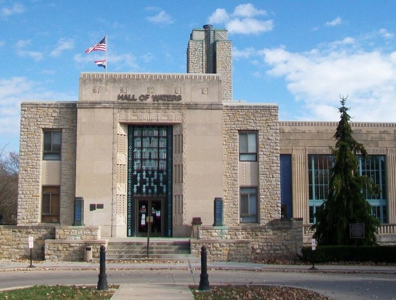
All of the mineral springs brought together in this building in 1935 under W.P.A. on the site of the original spring. The cost was more than one million dollars. It is unique with the world's longest mineral water bar. — — Map (db m162679) HM
On NE Antioch Road (Missouri Route 1) at NE 48th Street, on the right when traveling north on NE Antioch Road.
Congregation established in 1853 by Rev. Moses E. Lard as Christian Church. Building constructed 1859. Has served since as worship and social center. Reorganized as Community Church 1930. Building moved and [illegible] by Antioch Church Historical . . . — — Map (db m86639) HM
On Northeast 48th Street, 0.3 miles east of Worlds of Fun Avenue, on the right when traveling east.
dedicated cemetery dating to the earliest days of Clay County. Many pioneers are buried here including James Crowley, a Revolutionary soldier. — — Map (db m140837) HM
On Flintlock Road, 0.4 miles north of Missouri Highway 152, on the right when traveling south.
Homeplace settled by Elbridge Arnold in 1838, home built in 1856. Family home of William A. Crouch 1922 until it became the home of Edwin Yancey Crouch in 1940. — — Map (db m49819) HM
Home of Rev. Robert James, Baptist minister who came here in 1840. Son Jesse was born here and with his brother Frank, were involved with the Bushwhackers in criminal escapades until Jesse was killed in 1882. Frank surrendered and lived with his . . . — — Map (db m59638) HM
Near Missouri State Highway EE (Missouri Route EE) 0.5 miles south of Missouri Highway H.
Built by Daniel Bell in 1858, an impressive ante-bellum mansion, restored by present owner, Donald Pharis, who also re-erected an early day log cabin here from nearby Richmond. — — Map (db m80964) HM
On Kansas Street at Main Street, on the right when traveling east on Kansas Street.
This property built in c.1895
has been placed on the
National Register
of Historic Places
by the United States
Department of Interior
1993
Formerly the Messick Hotel, was purchased by Sterling Price Boggess in 1902 and operated . . . — — Map (db m68155) HM
On Main Street south of Franklin Street, on the right when traveling south.
Drugstore built in 1877 by Daniel Hughes. Owned by Wm. Goodson after 1908. Operated by Joseph Simmons until 1945, then by Clarence Ferril. Purchased from Goodson estate complete with furnishings by Historical Museum in 1965. Walnut cabinets are . . . — — Map (db m68128) HM
On Water Street north of Mill Street, on the left when traveling north.
Originally John Owens' log tavern near Liberty Spring. Used for court sessions until 1831, when the permanent court house was built on the square.
Bicentennial 1976 — — Map (db m68310) HM
On Mississippi Street at Leonard Street, on the left when traveling east on Mississippi Street.
"Steamboat Gothic" design, circa 1870's. Owned by Manheim Goldman, the first permanent Jewish settler in the metropolitan area who operated a store in Liberty. Twice Mayor of Liberty, a founder and chief benefactor of the Odd Fellows Home. . . . — — Map (db m68239) HM
On Water Street north of Franklin Street, on the right when traveling north.
Built in 1858, only ante-bellum building remaining on the square. Originally housed a branch of the Farmer's Bank. Scene of first daylight robbery in 1866, supposedly by James-Younger gang. Restored to original appearance by Jack Wymore. . . . — — Map (db m68210) HM
On Main Street at West Mississippi Street, on the left when traveling north on Main Street.
Site of Liberty Jail built in 1833 and used by Clay County in 1856. Joseph Smith and associates held here awaiting trial in 1838-39. Restored as a Historic Site by the Mormon Church in 1963. — — Map (db m90343) HM
On Main Street at Mississippi Street, on the right when traveling north on Main Street.
Organized in 1829, first building on this site in 1852, present one in 1888. Additions follow the same architectural pattern. This was the first "Old School" Presbyterian in the County. — — Map (db m68241) HM
On Main Street north of Franklin Street, on the left when traveling north.
Established by Robert Hugh Miller in 1846, and continually published since. Oldest weekly newspaper west of the Mississippi River. Has had several locations. Bought by Townsend Publications. — — Map (db m68212) HM
On Leonard Street, 0.1 miles south of Kansas Street, on the right when traveling north.
This small frame church was built circa 1842 and is one of the oldest remaining buildings in Liberty. It is build of brick and stucco and has served several uses. In 1855 it became part of the Clay Seminary, an all girls school. One of its most . . . — — Map (db m45678) HM
On Main Street, on the right when traveling north.
Organized in 1875 by Rev. Jesse Mills. First church built in 1876. Present structure dedicated 1942 under pastorate Rev. A.G. Thurman, who also supervised construction. 104th anniversary celebrated 1979 under Rev. Jack Wills. — — Map (db m68240) HM