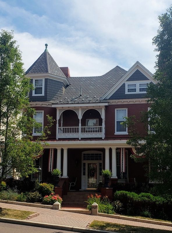
On Columbia Street, 0.1 miles west of Polk Street, on the right when traveling west.
Wright Butler House
has been placed on the
National Register
of Historic Places
by the United States
Department of the Interior
c. 1896
— — Map (db m139114) HM
On 1st Street close to Uhl Street, on the right when traveling west.
Erected in 1912, the St. Michaels' Parish Hall served the members of St. Michaels' Church and the Frostburg Community for the past 100 years. As the St. Michael parish continued to grow at the end of the 19th century, a school was added in 1891. . . . — — Map (db m199917) HM
On Duke of Gloucester Street just west of Market Street, on the right when traveling east.
The project will create a useful office/meeting space on the first floor for City functions and include exhibits about the Maynard and Burgess families based on decades of research by historians and archaeologists.
John Maynard, a . . . — — Map (db m232494) HM
On Severn Avenue at First Street, on the right when traveling east on Severn Avenue.
This is the oldest house in Eastport. For nearly 100 years it belonged to the Williams family.
Jonas and Louisa Williams and their eight children moved here in 1876. They used the first floor as a grocery store, selling homemade sauerkraut . . . — — Map (db m114880) HM
On South Beach Road, on the left when traveling south.
The property know today as Sandy Point State Park is a collection of several parcels
of land previously known as Tryall, Scotland, Rattle Snake Point and Gibson's Discovery. The brick constructed Sandy Point Farmhouse exemplifies several . . . — — Map (db m221225) HM
On West Lexington Street just west of North Eutaw Street, on the right when traveling west.
Over the years, the Market has had at least 10 different buildings and countless carts and stalls from the vendors on the street. At times, sheds of wood, stone, and concrete have stretched entire city blocks. Lexington Market's heart and soul, . . . — — Map (db m243488) HM
On West Lexington Street west of North Eutaw Street, on the right when traveling west.
The lore of Lexington Market has always loomed almost as large as its public market prowess. From myths of catacombs under the old West Market (really tunnels used by butchers and produce vendors for cold storage before modern refrigeration), to the . . . — — Map (db m243479) HM
On East Baltimore Street at South Chester Street, on the right when traveling east on East Baltimore Street.
2101 East Baltimore Street
Built c. 1875
Restored by The Siegel Organization
has been placed on the
National Register
of Historic Places
by the United States
Department of the Interior — — Map (db m212979) HM
On West Saratoga Street at Charles Street, on the right when traveling west on West Saratoga Street.
The building Brown's Loft Apartments, located here at 300 N Charles St, was built in 1875. Historically the building served many functions, most notably housing the YMCA. The mixed-use building now features 39 stunning loft style apartments and . . . — — Map (db m210767) HM
Near Safari Place north of Beechwood Drive, on the right when traveling north.
The Maryland Building was originally constructed in Philadelphia as Maryland's state exhibition hall for the 1876 Centennial Exhibition, the first World's Fair held in the United States.
After the fair, the building was disassembled, . . . — — Map (db m189048) HM
On Historic Main Valley, on the right when traveling north.
When Mary Ann, our first elephant, arrived in 1925 she needed a place to live so this building was created for her.
Beginning in 1920, a group of Baltimore schoolchildren helped collect the funds to buy MaryAnn. This building, . . . — — Map (db m212301) HM
On East Coast Greenway west of East Drive, on the right when traveling west.
For 150 years, the estate at Druid Hill was owned by just two families, the Rogers and the Buchanans. The Mansion House, built in 1801, is the third residence to be constructed on the site. The second home, built by Nicholas Rogers in the late . . . — — Map (db m212293) HM
On East Montgomery Street just east of Light Street (Maryland Route 2), on the left when traveling east.
This property is listed on the National Register [of Historic Places]
as part of
Federal Hill
National Historic District
and is registered with the
Preservation Society
c. 1800 — — Map (db m189931) HM
On East Montgomery Street just east of Light Street, on the right when traveling east.
This property is listed on the National Register [of Historic Places]
as part of
Federal Hill
National Historic District
and is registered with the
Preservation Society
c. 1840-41 — — Map (db m189930) HM
On East Montgomery Street just east of Light Street, on the right when traveling east.
This property is listed on the National Register [of Historic Places]
as part of
Federal Hill
National Historic District
and is registered with the
Preservation Society
1840 — — Map (db m189929) HM
On East Montgomery Street just west of William Street, on the left when traveling east.
This property is listed on the National Register [of Historic Places]
as part of
Federal Hill
National Historic District
and is registered with the
Preservation Society
1896 — — Map (db m189932) HM
On East Montgomery Street just west of William Street, on the right when traveling south.
This property is listed on the National Register [of Historic Places]
as part of
Federal Hill
National Historic District
and is registered with the
Preservation Society
c. 1845 — — Map (db m189927) HM
On East Montgomery Street just east of William Street, on the left when traveling east.
This property is listed on the National Register [of Historic Places]
as part of
Federal Hill
National Historic District
and is registered with the
Preservation Society
1855 — — Map (db m189926) HM
On East Churchill Street just west of William Street, on the left when traveling east.
This property is listed on the National Register [of Historic Places]
as part of
Federal Hill
National Historic District
and is registered with the
Preservation Society
c. 1870 — — Map (db m189877) HM
On East Montgomery Street just west of William Street, on the left when traveling east.
This property is listed on the National Register [of Historic Places]
as part of
Federal Hill
National Historic District
and is registered with the
Preservation Society
1825 — — Map (db m189933) HM
On East Montgomery Street just west of William Street, on the left when traveling east.
This property is listed on the National Register [of Historic Places]
as part of
Federal Hill
National Historic District
and is registered with the
Preservation Society
1796 — — Map (db m189934) HM
On East Montgomery Street just east of William Street, on the right when traveling east.
This property is listed on the National Register [of Historic Places]
as part of
Federal Hill
National Historic District
and is registered with the
Preservation Society
c. 1820 — — Map (db m189936) HM
On East Churchill Street just east of William Street, on the right when traveling east.
This property is listed on the National Register [of Historic Places]
as part of
Federal Hill
National Historic District
and is registered with the
Preservation Society
c. 1860 — — Map (db m189869) HM
On East Churchill Street just west of Battery Avenue, on the left when traveling east.
This property is listed on the National Register [of Historic Places]
as part of
Federal Hill
National Historic District
and is registered with the
Preservation Society
c. 1860 — — Map (db m189867) HM
On East Montgomery Street just west of Battery Avenue, on the right when traveling east.
This property is listed on the National Register [of Historic Places]
as part of
Federal Hill
National Historic District
and is registered with the
Preservation Society
1872 — — Map (db m189935) HM
On Warren Avenue just west of Battery Avenue, on the right when traveling west.
This property is listed on the National Register [of Historic Places]
as part of
Federal Hill
National Historic District
and is registered with the
Preservation Society
1850 — — Map (db m145576) HM
On West Montgomery Street (Maryland Route 2) just west of Charles Street, on the left when traveling east.
This property is listed on the National Register [of Historic Places]
as part of
Federal Hill
National Historic District
and is registered with the
Preservation Society
c. 1850 — — Map (db m192387) HM
On William Street just north of East Churchill Street, on the left when traveling north.
This property is listed on the National Register [of Historic Places]
as part of
Federal Hill
National Historic District
and is registered with the
Preservation Society
c. 1850 — — Map (db m189925) HM
On William Street just south of East Churchill Street, on the right when traveling north.
This property is listed on the National Register [of Historic Places]
as part of
Federal Hill
National Historic District
and is registered with the
Preservation Society
circa 1840 — — Map (db m189870) HM
On William Street north of Warren Street, on the left when traveling north.
This property is listed on the National Register [of Historic Places]
as part of
Federal Hill
National Historic District
and is registered with the
Preservation Society — — Map (db m240365) HM
On William Street just north of Warren Avenue, on the right when traveling north.
This property is listed on the National Register [of Historic Places]
as part of
Federal Hill
National Historic District
and is registered with the
Preservation Society — — Map (db m189872) HM
On East Montgomery Street (Maryland Route 2) just east of Charles Street, on the right when traveling east.
This property is listed on the National Register [of Historic Places]
as part of
Federal Hill
National Historic District
and is registered with the
Preservation Society — — Map (db m192386) HM
On East Churchill Street just east of Light Street, on the left when traveling east.
This property is listed on the National Register [of Historic Places]
as part of
Federal Hill
National Historic District
and is registered with the
Preservation Society
c. 1840-41 — — Map (db m189875) HM
This property is listed on the National Register [of Historic Places]
as part of
Fell's Point
National Historic District
and is registered with the
Preservation Society
c. 1795
— — Map (db m145474) HM
On Shakespeare Street just west of South Bethel Street, on the left when traveling west.
This property is listed on the National Register [of Historic Places]
as part of
Fell's Point
National Historic District
and is registered with the
Preservation Society
— — Map (db m145478) HM
On Lancaster Street just west of South Bethel Street, on the left when traveling west.
This property is listed on the National Register [of Historic Places]
as part of
Fell's Point
National Historic District
and is registered with the
Preservation Society
— — Map (db m145472) HM
On Shakespeare Street just east of South Bethel Street, on the left when traveling west.
This property is listed on the National Register [of Historic Places]
as part of
Fell's Point
National Historic District
and is registered with the
Preservation Society
c. 1790
— — Map (db m145481) HM
On Shakespeare Street just east of South Bethel Street, on the right when traveling west.
This property is listed on the National Register [of Historic Places]
as part of
Fell's Point
National Historic District
and is registered with the
Preservation Society
— — Map (db m145484) HM
On Shakespeare Street just west of South Broadway.
This property is listed on the National Register [of Historic Places]
as part of
Fell's Point
National Historic District
and is registered with the
Preservation Society
1890
— — Map (db m145486) HM
On Lancaster Street just west of South Broadway, on the left when traveling west.
This property is listed on the National Register [of Historic Places]
as part of
Fell's Point
National Historic District
and is registered with the
Preservation Society
c. 1795
— — Map (db m145471) HM
On Lancaster Street just east of South Regester Street, on the left when traveling west.
This property is listed on the National Register [of Historic Places]
as part of
Fell's Point
National Historic District
and is registered with the
Preservation Society
c. 1869
— — Map (db m145469) HM
On Lancaster Street just west of South Ann Street, on the left when traveling west.
This property is listed on the National Register [of Historic Places]
as part of
Fell's Point
National Historic District
and is registered with the
Preservation Society
c. 1850
— — Map (db m183381) HM
This property is listed on the National Register [of Historic Places]
as part of
Fell's Point
National Historic District
and is registered with the
Preservation Society
c. 1803
— — Map (db m145468) HM
On South Durham Street just north of Lancaster Street, on the right when traveling north.
This property is listed on the National Register [of Historic Places]
as part of
Fell's Point
National Historic District
and is registered with the
Preservation Society
1839
— — Map (db m183383) HM
On South Regester Street just north of Lancaster Street, on the left when traveling north.
This property is listed on the National Register [of Historic Places]
as part of
Fell's Point
National Historic District
and is registered with the
Preservation Society
— — Map (db m150319) HM
On South Bond Street just north of Shakespeare Street, on the left when traveling south.
813 South Bond Street
c. 1820
This property is listed in the
National Register
of Historic Places
as a contributing member of
Fell's Point Historic District — — Map (db m172345) HM
On South Bond Street just south of Shakespeare Street, on the left when traveling south.
This property is listed on the National Register [of Historic Places]
as part of
Fell's Point
National Historic District
and is registered with the
Preservation Society
— — Map (db m145488) HM
On Market Place just north of East Pratt Street, on the right when traveling north.
700 East Pratt is a revival of the original 1912 Candler Building, once treasured by all of Baltimore and beyond. Originally housing the Coca-Cola Company, it set the foundation for the type of building to appear in major cities in the early . . . — — Map (db m183366) HM
On West Conway Street at South Sharp Street, on the right when traveling west on West Conway Street.
"Mother Church" of the United Brethren in Christ. First chapel erected 1771, present edifice, 1785. Burial place of the denomination's founder, Philip Wilhelm Otterbein, pastor, 1774-1813. Lovely Lane Chapel, "Mother Church of American Methodism," . . . — — Map (db m13573) HM
Near North Charles Street (Maryland Route 139) at East 34th Street, on the left when traveling north.
In 1800, the wealthy Carroll family purchased the land that is now the Homewood campus and built a large summer house here. Several other buildings also sat on the property, including an 18th-century farmhouse, outbuildings for food preparation, . . . — — Map (db m166980) HM
On South High Street just north of Fawn Street, on the left when traveling north.
Circa 1919
Concetta and Angelo Pizza
now owned by
their great-great granddaughter
Virginia Ann Pizza
2000
and her mother
Mimi Roeder Vaughan — — Map (db m183569) HM
On West Madison Street at Cathedral Street, on the right when traveling west on West Madison Street.
The Morison is a pre-Civil War freestanding mansion constructed in 1852 as a private residence for Nathaniel Holmes Morison (1815-1890). In 1867, Morison became provost of the Peabody Institute. George Peabody, a Baltimore dry goods merchant . . . — — Map (db m183386) HM
On West Read Street just east of Cathedral Street, on the right when traveling east.
Built 1927 as the Medical Arts Building
Historically Renovated to Apartments 2009
A contributing property of the
Mount Vernon Place Historic District — — Map (db m183388) HM
The Washington Monument, constructed between 1815 and 1829, was the nation's first formal tribute to the leader of the United States. Following the custom of the day, the design was chosen in a competition and the cost defrayed by a public lottery. . . . — — Map (db m170980) HM
On Honeygo Boulevard at Belair Road (U.S. 1), on the right when traveling north on Honeygo Boulevard.
One of the largest houses in Maryland. Begun in 1773 by Corbin Lee. Completed in 1776 by Harry Dorsey Gough. East wing of the Mansion partially burned in 1824. Repaired by Harry Dorsey Gough Carroll ca. 1825. Restored by the owners in 1967. — — Map (db m213339) HM
This land was once part of one of the largest estates in Maryland---and one of the most impressive. The Ridgley family owned Hampton Plantation for more than 200 years, and their home and many farm buildings have changed little since the mid-19th . . . — — Map (db m188345) HM
Research indicated that the Jacob House log cabin was originally built in the 1840s by a former slave freed from the nearby plantation estate known as Hampton, owned by the Ridgely family, or from a smaller plantation known as Stevenson.
It . . . — — Map (db m226687) HM
On Central Avenue (Maryland Route 312) at East Belle Street, on the right when traveling south on Central Avenue.
The Railroad was completed to Ridgely in 1867. The Saulsbury home was one of the earliest residences in Ridgely. Erected in 1867 by James K. Saulsbury, the building combined a large store where a widely known general merchandise business was . . . — — Map (db m205482) HM
On South Main Street just south of Center Street, on the left when traveling north.
This site was originally Gorman's Blacksmith Shop, built in 1880. It was rebuilt as Ed Butler's Garage in 1919. It has also been home to several auto related businesses including:
• Ed Butler's Ford (shown in photo)
• Pusey . . . — — Map (db m199369) HM
On South Main Street (Maryland Route 808) south of Center Street, on the right when traveling south.
This building was originally the home of the Mt. Airy Savings Bank, which was taken over by the Commercial Bank of Maryland from Frederick in 1916. Since then, it has been home of a number of other businesses and institutions including: . . . — — Map (db m199368) HM
On South Main Street (Maryland Route 808) just south of Center Street, on the right when traveling south.
This site was originally the location of the Byron S. Dorsey Farm Implements and Hardware Store and the Mt. Airy Savings Bank, shown above. Later the Bank moved and the space was occupied by the Hub, which sold clothing and other sundries. After . . . — — Map (db m199399) HM
On South Main Street (Maryland Route 808) at Park Avenue, on the right when traveling south on South Main Street.
This was the site of the original American Store before it moved to another downtown location. It has been home to several food related establishments since then, most notably the Olde Town Restaurant. Other businesses that have been located here . . . — — Map (db m199405) HM