On South Main Street just south of Merriwether Street, on the right when traveling south.
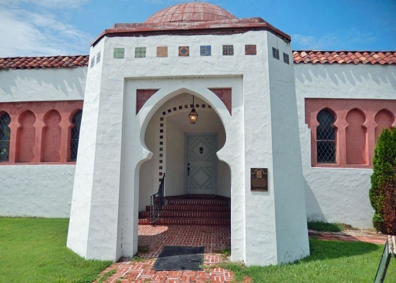
This building was constructed in 1937 by the Hecht family, the Jewish Community and local support from business and individuals alike. This synagogue served all of southeast Missouri’s Jewish citizens. With its Islamic influences, ceramic glazed . . . — — Map (db m235999) HM
On Broadway Street just west of North Fountain Street, on the right when traveling west.
The H&H building was built in 1908 by J.H. Himmelberger & W.H. Harrison, two of Cape Girardeau's most prominent businessmen. It was the first steel reinforced structure built in Cape Girardeau and has served as a commercial center for the business . . . — — Map (db m236185) HM
On Broadway Street just east of North Fountain Street, on the left when traveling east.
1928 — The former Marquette Hotel was completed around the time the first bridge opened linking Cape Girardeau to Illinois. The bridge boosted Cape Girardeau's economy and became a popular place for traveling business men and families to stop . . . — — Map (db m236200) HM
On North Lorimier Street at Broadway Street, on the left when traveling north on North Lorimier Street.
[Lorimier Street marker] Built in 1924-25 newspaper owners George & Fred Naeter wrote of their inspiration: “to add in a large way beauty and dignity to one’s town is to express affection for the community and confidence in its future.” . . . — — Map (db m236100) HM
On West Main Street just east of Lafayette Street, on the right when traveling west.
Probably built as a two family home, this structure was built by Francis Arnold Becker of St. Albans, Missouri in 1871 and upon his death in 1886 was willed to his son Louis. — — Map (db m169275) HM
On Smith Street at Clay Street, on the right when traveling south on Smith Street.
National Register of
Historic Places
Built - 1884
Rededicated 1984
————————
This property has been
placed on the
National Register
of Historic Places
by the United States . . . — — Map (db m66585) HM
The Ray House is the only park structure on its original site that dates back to the Battle of Wilson's Creek. Postmaster and farmer John Ray built it in the 1850s. For ten years it served as the Wilson's Creek Post Office, a stopping place on the . . . — — Map (db m35198) HM
On Walnut Street, on the left when traveling east.
The Landers Theatre was built in 1909 by John and Douglas J. Landers. It opened with a production of "The Golden Girl." Lillian Russell, Sousa's Band and Fanny Brice have all appeared here. The Landers was the 35th theatre in the nation to show . . . — — Map (db m43122) HM
On Market Street just west of 4th Street, on the right when traveling west.
This library was provided for in the will of Benjamin W. Lewis, whose fortune was made in tobacco, to the extent of $10,000.00. The building of Italian Renaissance architecture was erected in 1866 at a cost of $26,000.00 through the benevolence of . . . — — Map (db m216981) HM
On Commerce Street (State Highway 240) just east of 4th Street, on the right when traveling east.
The Glasgow Presbyterian Church organized March 9, 1845, with ten members. First church building stood on Second Street between Market and Howard, was burned in October 1864 during the Battle of Glasgow. The congregation held services for some . . . — — Map (db m216985) HM
On Lexington Avenue near Main Street, on the right when traveling west.
A Century of Progress marks the development of Jackson County. In 1828 a log courthouse was built in Independence. In 1836 a brick building was erected as a permanent courthouse on this site. Soldiers returning from the Mexican War found an . . . — — Map (db m34898) HM
On Main Street at Truman Road, on the right when traveling north on Main Street.
Fire Station No. 1 operated here from 1907 to 1972. This current building, constructed in 1927, housed fire equipment on the first floor with sleeping quarters and a kitchen above. — — Map (db m34800) HM
On Pacific Avenue at Osage Street, on the left when traveling west on Pacific Avenue.
About 1856, John Lewis erected this mansion on 22 acres he had owned since 1845. George Caleb Bingham, the famous Missouri genre painter, bought the farm in 1864 and lived here until 1870. W.H. Waggoner, mill owner, bought it in 1876. The family . . . — — Map (db m34834) HM
Designed for Harvey M. Vaile, operator of Star Mail routes, by Asa Cross of Kansas City, this Second Empire style house was described in 1881 as "one of the most costly and beautiful residences" in the county. Listed on the National Register of . . . — — Map (db m82634) HM
On 47th Street (U.S. 56) at Baltimore Avenue, on the right when traveling east on 47th Street.
The inspiration for the design of this tower came from the original Giralda Tower which is a part of the great cathedral of Seville, Spain — — Map (db m80596) HM
On 13th Street, 0.1 miles east of Central Avenue, on the right when traveling west.
Kansas City’s expression of service and hospitality has a rich historical heritage starting in 1899, when the original convention hall opened with a concert by John Philip Sousa and his band. The success of the hall was proven when the Democratic . . . — — Map (db m86215) HM
On 9th Street west of Baltimore Avenue, on the right when traveling west.
Architects: Bradley, Winslow, & Wetherell
Constructed: 1887-88
The great building boom of the 1880's, when eastern business invested heavily in the new cities of the frontier, produced this and several other significant structures in Kansas . . . — — Map (db m64002) HM
On 9th Street at Baltimore Avenue, on the right when traveling west on 9th Street.
Architects: McKim, Mead and White
Constructed: 1887-90
This Neo-Renaissance Style office building symbolizes the faith of the moneyed East in Kansas City during the unprecedented prosperity of the 1880's. The bronze eagle was cast in the . . . — — Map (db m64003) HM
On Walnut Street north of 9th Street, on the right when traveling north.
The exterior of the Scarritt Arcade with its ornate terra cotta shows the influence of Louis Sullivan and the 'Chicago School' of architecture. An interior skylighted open well, with windows on all sides, allows natural light into the offices . . . — — Map (db m88180) HM
On Highland Avenue, on the right when traveling north on Highland Avenue.
Has been designated a
National Historic Landmark
This site possesses national significance
In commemorating the history of the
United States of America
This hall used by Musicians Union Local #627 served as a center for the . . . — — Map (db m6706) HM
On Central Street at 9th Street, on the right when traveling north on Central Street.
The Savoy Hotel was constructed between 1890 and 1906 during a building boom which created some of the most architecturally significant buildings in the central business district. The first major hotel enroute from the old Union depot, it served as . . . — — Map (db m19831) HM
On West 11th Street, 0.1 miles west of Broadway Street, on the right when traveling east.
Father Donnelly came to Jackson County in 1845 to serve zealously for thirty five years as a frontier pastor at St. Mary's Church, Independence and Immaculate Conception Church, Kansas City. On this site of the first church property purchased in . . . — — Map (db m86219) HM
On Gillham Road near 39th Street & Harrison Parkway, on the right when traveling north.
The Park Maintenance Building, built in 1905, was designed as an "ornamental barn" by the master architect Adriance Van Brunt. The building, constructed of native limestonea and trimmed with vitrified brick, was to be used to house horses, . . . — — Map (db m44406) HM
On 61st Terrace, 0.1 miles east of Wornall Road, on the left when traveling east.
Built in 1858 by John Wornall on his 640-acre farm, this house was in the center of heavy fighting on October 23, 1864. After the last Confederate charge to the north toward Westport was repulsed, this house was used as a field hospital for both . . . — — Map (db m28072) HM
On 55st Street, 0.1 miles east of Ward Parkway, on the left when traveling east.
Situated on property once owned by Mormon Bishop Edward Partridge and by Alexander Doniphan, this homestead was acquired in 1858 by Colonel William W. Bent, founder of Bent's Fort, Colorado. In 1864, during Bent's residency, the farm pastures (now . . . — — Map (db m23177) HM
On State Line Road north of 83rd Street, on the right when traveling north.
In memory of Miss Louisa P. Johnston, great-granddaughter of Alexander Majors, whose steadfast determination led to the preservation of this house to honor him and the historic transportation firm of Russell, Majors and Waddell
and in recognition . . . — — Map (db m84744) HM
On SE Main Street north of SE 3rd Street, on the right when traveling north.
On May 9, 1895, Mr. R.H. Marquette established a cigar factory and store at this location. The store was a local gathering place for men in the community. Its popularity increased greatly when a bowling alley was added to the business years . . . — — Map (db m64129) HM
On Virginia Avenue south of 7th Street (Missouri Route 66), on the left when traveling south.
Jasper County, Missouri boasts two county courthouses -- one in Joplin and one in Carthage, the county seat. Actually, there could have been three county courthouses; Webb City also insisted upon having one. Bitter rivals in the 1890s, the three . . . — — Map (db m57767) HM
On Main Street (Missouri Route 43) near 4th Street, on the right when traveling north.
Built in 1882 by Thomas Cunningham to house the Cunningham National Bank. Present facade reflects a circa 1922 remodeling when the name was changed to the Quinby Building.
Partial facade restoration was made possible in 1990 by a grant from the . . . — — Map (db m35043) HM
On South Main Street (Missouri Route 43) south of 3rd Street, on the right when traveling south.
Joplin's original industries were lead and zinc mining, smelting and associated manufacturing. Joplin became the center of one of the most important mining fields in the world.
In 1906 and 1907 the Connor Hotel was built to provide . . . — — Map (db m34654) HM
On Holden Street at Market Street, on the left when traveling north on Holden Street.
Listed in the National Register
of Historic Places
April 7, 1995
Constructed of locally quarried sandstone, the present Johnson County Courthouse is the oldest of four Missouri courthouses designed by architect George E. McDonald of Omaha, . . . — — Map (db m85430) HM
The confectionery located at this site in the Allen Hotel Block, built in 1905, was a favorite stop for Marcelineans with a sweet tooth. When designing Downtown Disney, which is adjacent to Disneyland, the Disney Company included Marceline's . . . — — Map (db m62153) HM
On North Main Street at West Ritchie Ave, on the right when traveling south on North Main Street.
The Coca-Cola building on Main Street USA at Disneyland is modeled after the Zurcher Building you see here. Built in 1892, Zurcher Jewelers occupied this site from 1903 to 1973. In the Knights of Pythias hall, located in the second story, Elias . . . — — Map (db m62421) HM
On Jackson Street east of Locust Street, on the left when traveling east.
Courthouse Square
Historic District
has been placed on the
National Register of
Historic Places
by the United States
Department of [the] Interior
October 16, 2002 — — Map (db m156943) HM
On Washington Street (U.S. 65) north of Webster Street, on the left when traveling north.
[Clockwise from top left]
Ben Bolt Theatre • City Hall & Fire Dept
Mart Drug [former Leeper Hotel]
County Buildings • Fire Dept. • Leeper Hotel — — Map (db m156935) HM
On Court Square at North Main Street, on the left when traveling west on Court Square.
This property
has been placed on the
National Register of
of Historic Places
by the United States
Department of the Interior
December 28, 2000
— — Map (db m119704) HM
On North Street west of Main Street, on the left when traveling west.
In grateful recognition of
The Christina J. Coons Family for donations of
land to reconstruct the "Huckleberry Finn House."
The house that once stood here was
believed to be the home of Tom Blankenship,
named by Mark Twain as a model for . . . — — Map (db m156616) HM
On Hill Street west of Main Street, on the left when traveling west.
This was the home of Becky Thatcher, Tom Sawyer’s first sweetheart in Mark Twain’s book Tom Sawyer. Tom thought Becky to be the essence of all that is charming in womanhood. — — Map (db m4662) HM