On Patrick Henry Highway (U.S. 360) 0.3 miles west of Holly Farms Road, on the right when traveling west.
Nottoway County. Area 310 Square Miles. Formed in 1788 from Amelia, and named for an Indian tribe. Tarleton passed through this county in 1781. Here lived William Hodges Mann, Governor of Virginia 1910-14.
Amelia County. . . . — — Map (db m18925) HM
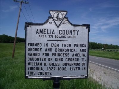
On Hull Street Road 1.6 miles west of Sappony Road, on the right when traveling west.
Amelia County. Area 371 Square Miles. Formed in 1734 from Prince George and Brunswick, and named for Princess Amelia, daughter of King George II. William B. Giles, Governor of Virginia 1827-30, lived in this county. . . . — — Map (db m18924) HM
On Grubb Hill Church Road (Virginia Route 609) 0.4 miles north of Ruffin Lane ( Route 716), on the right when traveling north. Reported permanently removed.
Patriot
Father John Bannister Tabb was born in Amelia County in 1845 at “The Forest”, the Tabb family plantation. A member of one of wealthiest families in Virginia, he was carefully schooled by private tutors until the age of 14, when . . . — — Map (db m35959) HM
On Holly Farms Road (Route 307) west of Thompson Lane, on the right when traveling west.
Nottoway County. Area 310 Square Miles. Formed in 1788 from Amelia, and named for an Indian tribe. Tarleton passed through this county in 1781. Here lived William Hodges Mann, Governor of Virginia 1910-14. (Reverse) Formed in . . . — — Map (db m10220) HM
On Miller Street at 5th Street SE ( Route 9694), on the right when traveling south on Miller Street. Reported permanently removed.
When the Russell Grove School in Amelia County grew too big for its building, land was found in Nottoway County near Burkeville for a new school. Built in 1892 to educate African-American girls, the new school was named Ingleside Seminary. It . . . — — Map (db m31042) HM
Near Grub Hill Church Road (Virginia Route 609) 0.4 miles north of Ruffin Lane ( Route 716), on the right when traveling north.
Tabb was born in 1845 at "The Forest" here in Amelia County into one of Virginia's oldest and wealthiest families, and was destined for the life of a gentleman farmer. The American Civil War changed everything for young John. Despite failing . . . — — Map (db m180255) HM
On Ingleside Street at Route 9694, on the left when traveling south on Ingleside Street.
When Russell Grove School in Amelia County grew too big for its building, land was found in Nottoway County for a new school. Built in 1892 to educate African American girls, the new school was named Ingleside Seminary. It was funded by . . . — — Map (db m224480) HM
On Otterburn Road (Virginia Route 614) 0.1 miles south of Leidig Street ( Route 634), on the left when traveling south. Reported permanently removed.
Russell Grove Presbyterian Church and the Russell Grove School were established as a result of the efforts of Mrs. Samantha Jane Neil, a Presbyterian missionary and teacher of African-American children after the Civil War. At first the school . . . — — Map (db m28927) HM
Near Campus Drive (County Route 378) near Chritanna Highway ( Route 46). Reported permanently removed.
Southside Virginia Community College has two campuses: the Christanna Campus in Alberta, which opened in 1970, and the John H. Daniel campus in Keysville, which opened in 1971. The college is part of the statewide system of community colleges . . . — — Map (db m30868) HM
On Fort Hill Road 1.1 miles west of Christanna Highway ( Route 46), on the right when traveling west. Reported permanently removed.
In 1714, at Governor Alexander Spotswood’s urging, the Virginia General Assembly funded the Virginia Indian Company, charged with building a fort on the banks of the Meherrin River in what would become Brunswick County. The fort would provide . . . — — Map (db m20197) HM
On College Drive 0.1 miles north of Windsor Avenue ( Route 46), on the right when traveling north. Reported permanently removed.
Saint Paul’s College began as a small parochial school founded by a newly ordained Episcopal deacon, the Rev. James Solomon Russell. Born into slavery, Russell attended seminary school in Petersburg. Within a year of graduation he had managed . . . — — Map (db m30870) HM
Near Lee Wayside Road near Anderson Highway (U.S. 60). Reported permanently removed.
Union Grove School is representative of the many one-room schools for African-American students in Buckingham County and throughout the area. The African-American members of the community built Union Grove around 1925, and like most schools, . . . — — Map (db m21148) HM
On C G Woodson Road (Virginia Route 670) 0.2 miles north of Liberty Road ( Route 759), on the right when traveling north. Reported permanently removed.
North of this sign is the birthplace of Dr. Carter G. Woodson. Dr. Woodson was born December 19, 1875, to former slaves, James Henry and Eliza Ann Riddle Woodson. Young carter left Buckingham to work in West Virginia when he was 17 years old. . . . — — Map (db m31608) HM
On Legrande Avenue (Virginia Route 47) at David Bruce Avenue ( Route 40) on Legrande Avenue. Reported permanently removed.
Beginning in 1937, Ambassador and Mrs. David K. E. Bruce anonymously gave money to 11 sites in Southside Virginia to build libraries. The Bruce libraries, as they were called, became the first public libraries to allow access to African . . . — — Map (db m31019) HM
On Tech Lane at Lunenburg Highway ( Route 40) on Tech Lane. Reported permanently removed.
Southside Virginia Community College has two campuses: the Christanna Campus in Alberta, which opened in 1970, and the John H. Daniel campus in Keysville, which opened in 1971. The college is part of the statewide system of community colleges . . . — — Map (db m31025) HM
On Cargills Creek Road (County Route 632) at Salem School Road (County Route 608), on the right when traveling west on Cargills Creek Road. Reported permanently removed.
After the Civil War, in the Red Oak area of Charlotte County, many freed slaves were welcomed to worship at Antioch Baptist Church, a traditionally white church. The Antioch congregation helped raise money to build Salem Baptist Church in . . . — — Map (db m30999) HM
On Matthews Jefferson Drive at East River Road, on the right when traveling south on Matthews Jefferson Drive. Reported permanently removed.
Virginia State University was chartered by the Virginia legislature in 1882 as the Virginia Normal and Collegiate Institute. Delegate Alfred W. Harris, an African-American attorney in Petersburg, championed the charter and supported it . . . — — Map (db m26005) HM
Near Cartersville Road (Virginia Route 45) at Columbia Road ( Route 690), on the right when traveling south.
Parents in the Cartersville area of Cumberland County met in 1909 to discuss the need for a centralized high school to replace the one-room schools serving white children in the area at that time. The county Superintendent of Schools led the . . . — — Map (db m31609) HM
Near Cartersville Road (Virginia Route 45) 0.1 miles north of Ampthill Road, on the right when traveling north.
Julius Rosenwald, a former president of Sears, Roebuck & Co., continued the efforts made by numerous philanthropists to bring education to African Americans in the South. During the early 1900s, funding for schools was scarce; the South had half . . . — — Map (db m21159) HM
On Foster Road at Anderson Highway (U.S. 60), on the left when traveling north on Foster Road. Reported permanently removed.
Jackson Davis, an educational reformer and amateur photographer, was born in Cumberland County, VA, to William Anderson and Sally Wyatt (Guy) Davis on September 25, 1882. He attended the public schools of Richmond, VA, and received his B.A. . . . — — Map (db m21150) HM
Near Sycamore Drive at Boydton Plank Road (U.S. 1). Reported permanently removed.
Prior to the Civil War, Dinwiddie County was home to several private academies for those who could afford to pay for their education. While it was mostly affluent males who were educated, Pegram’s Academy, Female Academy, Girard Heartwell . . . — — Map (db m26834) HM
Near 7th Avenue 0.5 miles north of Albermarle Street. Reported permanently removed.
In 1938 the Virginia Assembly chartered a residential care facility for mentally retarded African-American males between 8 and 21 years of age. The Petersburg State Colony for the Negro Insane, as it was named, was located on the present site . . . — — Map (db m23455) HM
On Rocky Branch Road (Virginia Route 636) 0.3 miles south of New Cox Road (U.S. 460), on the left when traveling south. Reported permanently removed.
In 1911 a group of Dinwiddie County’s African-American residents established the Rocky Branch School in Sutherland. The school was a typical two-room schoolhouse. It had been moved from original location across from Ocran Methodist Church on . . . — — Map (db m26833) HM
Near Cowford Road (Virginia Route 651) near Mary Bethune Street. Reported permanently removed.
In 1872 the Banister Baptist Association built a private African-American training school in Halifax County. Originally the campus consisted of four wooden buildings and a dormitory. The school year was six months, and the grades went only as . . . — — Map (db m30988) HM
On Ragland Street at Watkins Avenue, on the left when traveling east on Ragland Street. Reported permanently removed.
Many churches in the second half of the 19th century and early part of the 20th century helped fill African Americans’ need for schooling. Frequently the church would raise funds to build the school, with county governments occasionally . . . — — Map (db m30961) HM
On Jeffress Boulevard 0.1 miles east of Penick Avenue, on the right when traveling north. Reported permanently removed.
Determined to provide elementary education for young African Americans, the Rev. Parham B. Ragland started a school in his backyard some time around 1875. Though the "Backyard School" was private, Rev. Ragland was able to garner financial . . . — — Map (db m30970) HM
On Free State Road (County Route 630) 0.4 miles east of Payne Lane, on the right when traveling east. Reported permanently removed.
In 1880 a German Lutheran minister, the Rev. W. R. Buehler, a well-educated man who had worked for five years as a missionary in Africa, moved with his family to Green Bay, Virginia. He had not been in Green Bay long when the black community, . . . — — Map (db m31035) HM
On Tidewater Avenue at West 7th Street, on the right when traveling east on Tidewater Avenue. Reported permanently removed.
On May 13, 1947, several African-American leaders in Lunenburg County met at First Baptist Church in Victoria to discuss the need for a centrally located building large enough to accommodate countywide gatherings and educational activities . . . — — Map (db m31856) HM
On Highway Fifty Eight (U.S. 58) 0.1 miles east of Jefferson Street, on the right when traveling east. Reported permanently removed.
Boydton Academic and Bible Institute was opened in 1879 in building that had been abandoned by Randolph-Macon College when it moved to Ashland in 1868. Dr. Charles Cullis, a humanitarian from Boston, purchased the property in 1878 and opened . . . — — Map (db m30917) HM
On Highway Forty Seven (Virginia Route 47) at Village Road ( Route 874), on the left when traveling west on Highway Forty Seven. Reported permanently removed.
Thyne Institute was established by Rev. J.Y. Ashenhurst, United Presbyterian Church, and a group of local citizens to provide an opportunity for African Americans (known as “freedmen” in the late 1800s) to obtain an education. In 1876 73 . . . — — Map (db m31003) HM
On 4th Street at South Amelia Avenue, on the left when traveling west on 4th Street. Reported permanently removed.
The Blackstone Female Institute was conceived in 1891 by George Pierce Adams, a Blackstone merchant, and Joshua Soule Hunter, a Methodist minister. Originally designed as a school to prepare young female students to enter Randolph-Macon . . . — — Map (db m31045) HM
On Mt. Nebo Road 0.4 miles Walnut Hill Road, on the left when traveling north. Reported permanently removed.
Mt. Nebo Church was founded shortly after the Civil War in 1867. A northerner named Mr. Rickets bought the place called Oak Hill and began preaching to a group of African Americans at this place in the woods. The audience increased as people . . . — — Map (db m20242) HM
On Harrison Street at Maple Lane, on the left when traveling south on Harrison Street. Reported permanently removed.
Petersburg established a public school system in 1868, two years before the state’s mandate. Colored Elementary School #1 was conducted in the old church building of the African Baptist Church, which stood to your left. The building had been . . . — — Map (db m26011) HM
On South Jones Street 0.1 miles south of Lee Avenue, on the left when traveling south. Reported permanently removed.
Disrupted by the convulsions of the First World War, efforts to replace the increasingly inadequate Peabody School on Fillmore Street stretched out from 1913 until 1920, when the new Peabody-Williams School opened on Jones Street. Charles . . . — — Map (db m26012) HM
On South Main Street (U.S. 15) at 4th Street, on the right when traveling south on South Main Street. Reported permanently removed.
Beulah African Methodist Episcopal (AME) Church was founded in 1868. Originally, it was known as The Colored Methodist Church of Farmville. The original wooden-framed building was destroyed, by fire in 1898. The cornerstone on the present . . . — — Map (db m31318) HM
Near High Street (County Route 643) south of St George Street. Reported permanently removed.
Founded on March 5, 1839 as the Farmville Female Seminary Association, Longwood is one of the oldest colleges originally for women in the country. In 1842 the cornerstone was laid for the first true college building, which is today known as . . . — — Map (db m31316) HM
On South Main Street (U.S. 15) at 4th Street, on the right when traveling north on South Main Street. Reported permanently removed.
The First Baptist Church was organized in 1866 as an outgrowth of the predominantly white Farmville Baptist Church. In 1949, following the death of the Rev. C. H. Griffin, the Church voted unanimously to call his son, L. Francis Griffin, as . . . — — Map (db m31310) HM
On College Road (County Route 692) 0.3 miles south of Five Forks Road (County Route 658), on the right when traveling south. Reported permanently removed.
Hampden-Sydney College, in continuous operation since November 10, 1775, was established “to form good men and good citizens.” One of the few remaining all-male colleges, it was named for John Hampden (1594-1643) and Algernon Sydney . . . — — Map (db m31324) HM
Near Zion Hill Road (County Route 628) 0.1 miles east of McClendon Drive. Reported permanently removed.
In 1954, after the Supreme Court ruled in Brown vs. the Board of Education of Topeka, that United States schools must integrate, Senator Harry S. Byrd and several Virginia governors followed the policy of “massive resistance.” Integration was . . . — — Map (db m31321) HM
Near Griffin Boulevard at Barrow Street. Reported permanently removed.
On this site of the former R.R. Moton High School, the actions of some brave African-American students to achieve equal educational opportunities for blacks eventually led to the end of legal segregation in American public schools.
Moton . . . — — Map (db m31319) HM
On Cherry Street north of China Street, on the right when traveling north.
In 1831, Richard Featherston, a teacher,
built a single story structure here and
opened Vicksburg's first school. Dr. Alex
Magruder expanded the house to two stories
in 1850 and used the original as a clinic
where he treated victims of the . . . — — Map (db m191610) HM
Near Grub Hill Church Road (State Road 609) 0.3 miles south of North Lodore Road, on the right when traveling south.
Born in Middlesex County on November 24, 1754, Joseph Eggleston was brought to Amelia County at the age of four to be raised at the nearby family homestead of "Egglestetton". Private schooling at home led to his entrance into William and Mary . . . — — Map (db m262995) HM WM
On Blackstone Road (Virginia Route 40) north of Fletcher Chapel Road, on the right when traveling south.
Lunenburg County. Lunenburg County, organized in 1746, was named for King George II, Duke of Brunswick-Lüneburg. Nine counties were later formed from this "Mother of Counties." British Lt. Col. Banastre Tarleton raided here during the . . . — — Map (db m310204) HM
On Blackstone Road (Virginia Route 40) 0.4 miles north of Fletcher Chapel Road ( Route 601), on the left when traveling north. Reported permanently removed.
Lunenburg County. Lunenburg County was formed in 1746 from Brunswick County. Named for King George II, Duke of Brunswick-Lüneburg, a German possession of England's Hanoverian kings, Lunenburg County's territory originally included the . . . — — Map (db m31878) HM
Near Watson Road at North Battlefield Boulevard ( Route 168), on the left when traveling south.
(side 1)
This monument honors
Patriots who assembled
at this site in the Cause of
American Freedom in 1775
American Patriots
at the Battle
Second Virginia Regiment
Commanded by
Colonel William Woodford,
of . . . — — Map (db m211239) HM
This house was built by Judge Green, the father of equity jurisprudence in the state, who sat for twenty-one years in the Tennessee State Supreme Court. In 1852 he became a professor of Law at Cumberland University. Before settling in Lebanon, he . . . — — Map (db m100114) HM
On Patrick Henry Highway (U.S. 360) at Grub Hill Church Road ( Route 609), on the right when traveling west on Patrick Henry Highway.
Rosa Bowser, educator and social reformer, was enslaved at birth at Clay Hill plantation in Amelia County. Educated in Richmond's public schools, she taught school, supervised teachers, and helped form the first African American teachers association . . . — — Map (db m255027) HM
On Church Street at Virginia Street, on the left when traveling west on Church Street.
Noted lawyer and statesman William Branch Giles was born 12 Aug. 1762 in Amelia County and educated at Hampden-Sydney College, Princeton, and the College of William and Mary. Giles served Virginia in the United States House of Representatives . . . — — Map (db m19039) HM
On Virginia Street at Church Street, on the right when traveling south on Virginia Street. Reported permanently removed.
Amelia County is largely indebted to one woman for bringing formal education and religion to African Americans after the Civil War. In 1865 Mrs. Samantha Jane Neil left her home in Pennsylvania to search for her husband’s body. He had been a . . . — — Map (db m20239) HM
On Virginia Street (Virginia Route 1009) at Church Street ( Route 1003), on the right when traveling south on Virginia Street.
Amelia County is largely indebted to one woman for bringing formal education and religion to African Americans after the Civil War. In 1865 Mrs. Samantha Jane Neil left her home in Pennsylvania to search for her husband's body. He had been a . . . — — Map (db m180249) HM
On George Washington Memorial Highway (U.S. 17) south of Hickory Fork Rd, on the right when traveling north.
Robert Russa Moton was born in Amelia County, Virginia, on 26 August 1867, and was educated in a local freeman’s school and at Hampton Institute (now Hampton University). He served as an administrator at the institute from 1890 to 1915, when he . . . — — Map (db m297644) HM
On Fleet Street (State Highway 36) 0.1 miles north of Grove Avenue, on the right when traveling north.
When General Robert E. Lee's Army of Northern Virginia began its retreat from Petersburg and Richmond on the evening of April 2, 1865, part of the army crossed the Appomattox River at Campbell's Bridge here. Other columns crossed the river on three . . . — — Map (db m271544) HM
On Emanuel Church Road (Virginia Route 1002) north of Old Buckingham Road ( Highway 13), on the left when traveling north.
Emmanuel Episcopal
Church
has been registered as a
Virginia
Historic
Landmark
pursuant to the authority vested in the
Virginia Board of Historic Resources — — Map (db m265804) HM
On Congress Street at Charles Street, on the left when traveling west on Congress Street.
Following the election in 1846, Jefferson County became one of the first counties in Virginia to approve free schools for white students. Prior to that time boys and girls paid to attend private academies. The county was divided into 27 districts . . . — — Map (db m103644) HM
On Old Hwy 20 east of Morgan Drive, on the right when traveling east.
The town of Leighton was named in honor of the Reverend William Leigh, son and grandson of Revolutionary War veterans. He was born in Amelia County Virginia, Oct 4, 1790 and moved to Alabama about 1823. Leigh settled nearby at “Jeffers Cross . . . — — Map (db m278611) HM
On West Virginia Avenue (U.S. 460) just west of Lee Street (County Road T-1031), on the right when traveling east.
British Lieutenant Colonel Banastre Tarleton was tasked by Lord Charles Cornwallis to raid Southside Virginia and destroy ammunition, clothes, and "stores of any kind" destined for Continental military use.
Tarleton's Assignment
The . . . — — Map (db m182521) HM
On West Virginia Avenue (Route 460) just north of Lee Street (County Road T-1031), on the left when traveling west.
During Tarleton's Southside Virginia Raid (July 9 - July 24, 1781), British dragoons visited Benjamin Ward's Tavern at West Creek. Peter Francisco was serving as a militia scout and was at the tavern at the time. Legend tells as many as nine . . . — — Map (db m182520) HM
Thin black lines indicate changes in relevance. Between each pair of lines entries are ordered geographically but all have the same relevance.
* Inflectional forms of words are their plurals, singulars, and possessives as well as gramatical tenses and similar variations.