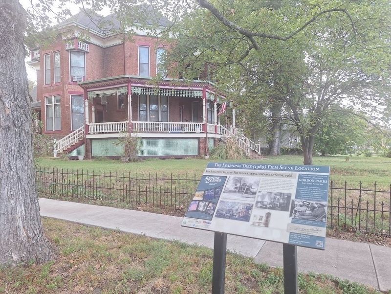
On South National Avenue near 10th Avenue, on the right when traveling south.
This scene location depicts the home of Judge Cavanaugh where filming was completed both inside and outside the home. This was the home in which Sarah Winger worked as a maid and where Newt and his mother and father talk to the Judge about the . . . — — Map (db m313452) HM
On East Wall Street at Hendricks Street, on the right when traveling west on East Wall Street.
Thanks for being here!
This walking trail idea was originally created by the Bourbon County LEAD class of '21, and finished by the class of '22. LEAD Bourbon County is a program organized by the Fort Scott Area Chamber of Commerce designed . . . — — Map (db m312753) HM
On North Main Street south of Old Fort Boulevard, on the right when traveling north.
Eugene Ware came to Fort Scott in 1874 where he joined the firm of McComas and McKeighan after passing the written law exam without a formal law degree. Eugene was a poet who went by the pen name Ironquill. Some of his published poems were used . . . — — Map (db m313190) HM
On Scott Avenue at East 3rd Street, on the left when traveling south on Scott Avenue.
Kansas was the first state to recruit, train, and send Black soldiers into combat during the Civil War. The 1st and 2nd Kansas Colored Infantry regiments were mustered into service on the parade ground of Fort Scott. Captain William Mathews was a . . . — — Map (db m313434) HM
On State Street at East Wall Street, on the right when traveling north on State Street.
Bourbon County has had three courthouse buildings. The first was built around 1855 when Fort Scott became the county seat. The second building was built in 1887 but destroyed by fire in 1929. The Court House was immediately rebuilt and still . . . — — Map (db m313441) HM
On East Wall Street at National Avenue, on the left when traveling west on East Wall Street.
Fort Scott was a dairy town and had 3 working dairies. Borden's canned and powdered milk was produced, boxed and shipped by rail to locations all over the United States. In the 1950's Batten Meadow Gold bought milk, bottled it, and delivered door . . . — — Map (db m312760) HM
On South National Avenue at East 3rd Street, on the left when traveling south on South National Avenue.
When you travel a great distance, how do you get there? In the 1840s, dragoon soldiers were stationed at Fort Scott to patrol the frontier. Trained to fight on horseback and on foot, the dragoons were often called on to travel great distances . . . — — Map (db m312941) HM
On Scott Avenue at East 2nd Street, on the left when traveling south on Scott Avenue.
Soldiers returned to the area during the Civil War. The Fort Scott served as a supply depot and an army hospital - the largest and most well-staffed hospital in the state of Kansas. Food, ammunition, and other supplies were sent in and out of the . . . — — Map (db m313436) HM
On Scott Avenue at East Wall Street, on the right when traveling north on Scott Avenue.
Since Fort Scott had such a large hospital during the Civil War and many soldiers were dying from wounds and illness, there needed to be a special cemetery located nearby. The US Government chose 12 locations to be national cemeteries and Fort . . . — — Map (db m313440) HM
Often referred to as the 'Father of Chemurgy', George Washington Carver was an African-American scientist, botanist and inventor who discovered more than 300 uses for peanuts. He is regarded as one among the '100 Greatest African-Americans' for . . . — — Map (db m312756) HM
On Old Fort Boulevard north of Wall Street, on the right when traveling east.
Fort Scott Community College was founded in 1919, the oldest 2-year college in continuous operation in Kansas. The term "JUCO" was coined here, with reference to when the community college was known as a junior college. The college moved to its . . . — — Map (db m312758) HM
On South Main Street at East 2nd Street, on the right when traveling south on South Main Street.
Gordon Parks spent the first 15 years of his life in Fort Scott. The last of 15 children born to parents Jackson and Sarah, he eventually lived with a sister in St. Paul, MN completing his education. He became an author, poet, musician, composer, . . . — — Map (db m312952) HM
On South Main Street at East 3rd Street, on the right when traveling north on South Main Street.
In 1905 Gunn Park was known as Fern Lake Park and was privately owned and operated. The fee to enter the park was 5 cents. On July 4, 1909 there were 10,000 visitors to Fern Lake Park to watch fireworks. In 1910 the owners had signed the park . . . — — Map (db m313197) HM
On South Main Street at 1st Street, on the right when traveling south on South Main Street.
Jacob "Merritt" Anthony 1834-1900 came to Fort Scott in April 1856 having followed John Brown, the militant abolitionist (free slave). Merritt owned and operated the Singer Sewing Machine Co. located at 11 W. Wall after the Civil War ended until . . . — — Map (db m312953) HM
On East 1st Street at Scott Avenue, on the left when traveling east on East 1st Street.
Judge Harry Fisher was born in 1887 in Linn County. Judge Fisher started his law practice in Linn County and later moved to Fort Scott. He was one of the judges for the bankruptcy court. He went on to the Kansas House of Representatives in 1932, . . . — — Map (db m313438) HM
On East 1st Street at National Avenue, on the left when traveling west on East 1st Street.
A young man once played on the baseball fields known as Judge Harry Fisher Park and Don Hewitt Field. Adam LaRoche would later become a Major League Baseball Player. He went on to play for the Pittsburgh Pirates, the Washington Nationals, and the . . . — — Map (db m312761) HM
On South National Avenue south of West 2nd Street, on the right when traveling north.
Located near the Overflow/RV lot of Fort Scott National Historic Site was the site of the Hawkins School from 1923-1956. Professor Ernest Hawkins led this African American school for several years. He encouraged his students to 'Look Sharp, Be . . . — — Map (db m312936) HM
On South Main Street at East 2nd Street, on the right when traveling north on South Main Street.
In the height of the railroad era 1870-1890's, numerous rail lines ran through Fort Scott and there were once five railway stations. Today, the Burlington Northern/Santa Fe Railroad is the only line that remains. The M.K.T. train depot was moved . . . — — Map (db m313194) HM
On South Main Street south of Wall Street, on the right when traveling north.
The Stout Building at 102 N. National Ave. was built in 1912 by Durkee and Stout. They were the Fort Scott Grain and Implement Co. and sold John Deere, Kingman, and International as well as buggies, carriages, and wagons. In later years they . . . — — Map (db m313192) HM
On North Main Street at Wall Street, on the left when traveling north on North Main Street.
The city has 12 miles (once had 30 miles) of streets paved with bricks which were manufactured at the Fort Scott Brick Factory. Approximately 1 million of Fort Scott's bricks were used to build the Panama Canal. Fort Scott's first brick company . . . — — Map (db m313189) HM
On West 2nd Street near Willow Avenue (Old U.S. 66), on the right when traveling east.
The Osage at Baxter Springs
The Osage once controlled a vast territory in the center of North America. In the mid-1600s, the tribe moved to the area around Baxter Springs. The area was important to the Osage because, for the tribe, it was . . . — — Map (db m174252) HM
Thin black lines indicate changes in relevance. Between each pair of lines entries are ordered geographically but all have the same relevance.
* Inflectional forms of words are their plurals, singulars, and possessives as well as gramatical tenses and similar variations.