Near Susquehanna Street (U.S. 209) 0.1 miles south of Race Street, on the left when traveling south.
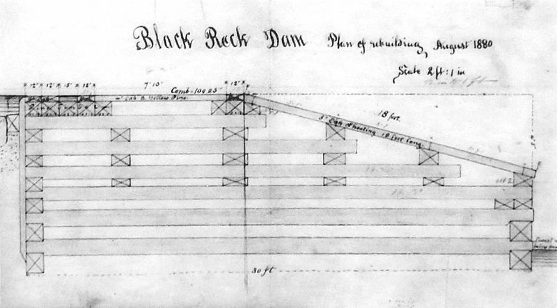
"It should be borne in mind that in timber dams it is the weight of the stone ballast that keeps the structure in place, and not the bulk and combination of the timbers." Edwin F. Smith, Dam Building in Navigable and Other Streams . . . — — Map (db m138500) HM
Near Susquehanna Street (U.S. 209) 0.1 miles south of Race Street, on the left when traveling south.
"The problem of getting coal from wagon to ark was solved by constructing an inclined loading chute at Mauch Chunk that extended downward from Mount Pisgah to a coal-loading house along the Lehigh River. The coal house projected over the river's . . . — — Map (db m138499) HM
Near Susquehanna Street (U.S. 209) 0.1 miles south of Race Street, on the left when traveling south.
"The class that resort here are select, intelligent, of quiet, unostentatious manners, who mostly come here for health and to admire and study the wonders and beauties of nature..."
The Health and Pleasure-Seeker's Guide, 1874
By . . . — — Map (db m138507) HM
Near Rockport Road 1 mile east of South Lehigh Gorge Drive.
Naturalist and artist John James Audubon visited Rockport in 1829 and hiked the surrounding forests sketching native birds. Already, the transformation was in progress. "One full third of trees have already been culled," he wrote in his . . . — — Map (db m225719) HM
On Center Avenue at Church Alley, on the left when traveling west on Center Avenue.
"A quarter of an hour's walk from the hotel up a very steep incline…brought me to…the Mauch Chunk and Summit Hill Railroad Depot."
"Special Correspondent, New York Times, December 14, 1872, p . . . — — Map (db m252159) HM
Erected by Col. Benjamin Franklin in the winter of 1758 at the order of the Province of Pennsylvania. The fort consisting of the two block houses and a well, surrounded by a stockade, was situated 201 feet southwest of this spot. It was used as a . . . — — Map (db m86885) HM
On Sanderson Street just east of North 3rd Street, on the right when traveling west.
Here in this Schuylkill County prison yard on June 21, 1877, the largest mass execution in Pennsylvania took place with the hanging of six alleged "Molly Maguire" leaders. That same day, four other alleged "Mollies" were hanged at Mauch Chunk in . . . — — Map (db m259048) HM
Near Lehigh Avenue (U.S. 209) at Lehigh Gorge Trail.
“Our residents take pride and partner in their heritage — they understand the meaning of what we have and act to preserve it” Delaware & Lehigh National Heritage Corridor and State Heritage Park, Management Action Plan. . . . — — Map (db m153540) HM
On Lehigh Gorge Trail 1.7 miles west of Main Street, on the right when traveling north.
“Our residents take pride and partner in their heritage — they understand the meaning of what we have and act to preserve it” Delaware & Lehigh National Heritage Corridor and State Heritage Park, Management Action Plan. . . . — — Map (db m153538) HM
Near Main Street south of Berwick Street (Pennsylvania Route 940) when traveling south.
“Our residents take pride and partner in their heritage — they understand the meaning of what we have and act to preserve it” Delaware & Lehigh National Heritage Corridor and State Heritage Park, Management Action Plan. . . . — — Map (db m114641) HM
Welcome to the Delaware and Lehigh National and State Heritage Corridor, a collection of people, places and events that helped shape our great nation. Come journey through five Pennsylvania counties bursting with heritage and brimming with . . . — — Map (db m114644) HM
On D&L Trail - Lehigh Canal (North) 0.1 miles north of Bridge Street, on the left when traveling north.
Community landscapes can reveal our past. This part of the Delaware & Lehigh National Heritage Corridor has a lot of stories to tell. You'll see distinctive types of towns. Traditional market towns formed as crossroads commercial centers, . . . — — Map (db m252050) HM
On North Street (Pennsylvania Route 903) 0.1 miles north of 13th Street, on the left when traveling north.
"Sir, you are the greatest athlete in the world."
King Gustav V of Sweden
Born in Oklahoma Territory in 1888, Jim Thorpe was a member of the Sac and Fox tribe. Prophetically named Wa-tho-huck (Bright Path) by . . . — — Map (db m307779) HM
Entrepreneur Asa Parker founded the Lehigh Valley Railroad (LVRR) in 1853 to more efficiently transport anthracite coal to market. A freight and passenger station was constructed on this site in 1862. The LVRR Slatedale Branch opened in 1870 for the . . . — — Map (db m85695) HM
Welcome to Delaware and Lehigh National and State Heritage Corridor, a collection of people, places and events that helped shape our great nation. Come journey through five Pennsylvania Counties bursting with heritage and brimming with outdoor . . . — — Map (db m114643) HM
On Sullivan Trail (Pennsylvania Route 191) 0.1 miles south of Bangor Road ( Route 191), on the left when traveling south.
“Our residents take pride and partner in their heritage—they understand the meaning of what we have and act to preserve it”
Delaware & Lehigh National Heritage Corridor and State Heritage Park, Management Action Plan.
Welcome to . . . — — Map (db m268093) HM
“Our residents take pride and partner in their heritage—they understand the meaning of what we have and act to preserve it”
Delaware & Lehigh National Heritage Corridor and State Heritage Park, Management Action . . . — — Map (db m114642) HM
On West Broadway at High Street, on the right when traveling west on West Broadway.
On June 21, 1877, four "Molly Maguires," an alleged secret society of Irish mine-workers, were hanged here. Pinkerton detective James McParlan’s testimony led to convictions for violent crimes against the coal industry, yet the facts of the labor, . . . — — Map (db m32153) HM
On Packer Hill Road west of East Calawissa Street.
"…there is no distinction to which any young man may not aspier, and with energy, diligence, intelligence, and virtue, obtain."
From Asa Packer's 1867 biography
"The Rich Men of the World and How they Gained their . . . — — Map (db m32270) HM
On Packer Hill Avenue north of Hazard Square, on the left when traveling north.
"I mention these circumstances as an encouragement of what may be accomplished by a life of integrity, energy and devotion to business."
Matthew S. Henry, 1860, History of the Lehigh Valley
On Iron Street at South 8th Street, on the right when traveling east on Iron Street.
"The truly spectacular feature of the Carbon County Fair… was the airport. Jake Arner's big hanger stood at the southern end of the midway, and during fair week local private pilots were available to take all comers who could pay . . . — — Map (db m252105) HM
On North Street (Pennsylvania Route 903) 0.1 miles north of 13th Street, on the left when traveling north.
The Indian wars were over and the Army had moved the Indians to forts and reservations. A young Army officer named Richard Henry Pratt had taken part in the Indian fighting and subsequent subjugation of the Indians. His observations had caused . . . — — Map (db m116601) HM
On Franklin Street at Bridge Street, on the right when traveling north on Franklin Street.
Almost 250 years before President George Bush designated a department of homeland security to help protect Americans from terrorist attack, Pennsylvania's colonial governor, Robert H. Morris, selected someone known for his great ingenuity to . . . — — Map (db m252095) HM
Thin black lines indicate changes in relevance. Between each pair of lines entries are ordered geographically but all have the same relevance.
* Inflectional forms of words are their plurals, singulars, and possessives as well as gramatical tenses and similar variations.