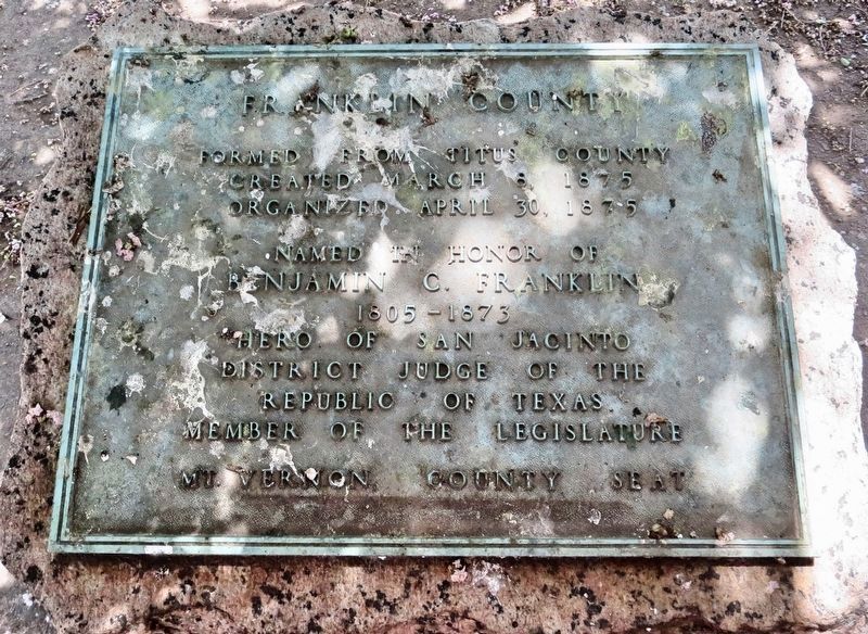
Formed from Titus County
Created March 8, 1875
Organized April 30, 1875
Named in honor of
Benjamin C. Franklin
1805 – 1873
Hero of San Jacinto
District Judge of the
Republic of Texas.
Member of the Legislature . . . — — Map (db m119672) HM
On U.S. 67 at County Road NE2050, on the right when traveling east on U.S. 67.
The picnic area on US 67 in Franklin County is an early roadside park developed by the Texas Highway Department - now Texas Department of Transportation. It was built from 1939-1940 using labor from the National Youth Administration, a Federal Works . . . — — Map (db m120299) HM
On McElroy Lane 1 mile north of San Felipe Road (County Highway 31), on the right when traveling north.
Pioneer, farmer, soldier, and county official Mike Muckleroy was born in Franklin County, Tennessee, and came to Texas in 1840. An early and long-time resident of Colorado County, he came to be affectionately known throughout the area as "Uncle . . . — — Map (db m176234) HM
Member of Nacogdoches Volunteers 2nd Regiment, Texas Volunteers Battle of San Jacinto
Early Texas Ranger Commanding Officer, Fort Houston Houston County Rangers Battle of the Neches July 16 - 17, 1839
Texas Ranger. Mounted Rifleman . . . — — Map (db m212224) WM
On Interstate 10 Frontage Road at Enchanted Lane, on the right when traveling west on Interstate 10.
Born in Franklin County, Tennessee, Claiborne West moved as a young man to Louisiana. He married Anna Garner in 1824 and they had nine children. His family immigrated to this area in 1825 and received a land grant in the Cow Bayou settlement. . . . — — Map (db m190730) HM
On E 20th Street at Paige Street on E 20th Street.
Tennessee native John McQueen Taylor came to Texas with his family in 1829 as a settler in the Empresario Grant of Lorenzo de Zavala. Taylor fought in the Anahuac disturbances of 1834 and later, as a soldier in the Texas army, he participated in . . . — — Map (db m23483) HM
Tennessee native Khleber Miller Van Zandt moved to east Texas as a child. After serving as a major in the 7th Texas Infantry Regiment, C.S.A., he came to Fort Worth in 1865. A merchant, banker, and rancher, he was instrumental in making the city a . . . — — Map (db m264157) HM
On West Front Street east of Cedar Street, on the right when traveling west.
The Pacific Railroad became a reality in Washington in February, 1855. This event allowed Washington to become the largest and most industrialized city in Franklin County. Many changes have occurred since that time within the railroad system. . . . — — Map (db m124372) HM
On County Road 3070 0.1 miles west of County Road 115, on the right when traveling west.
Primitive Baptist Church charted 1842.
Oldest marked grave 1870.
Land donors to expand are listed on the historical plaque
located in the center of cemetery grounds.
Perpetual care established in May 1968.
Gate erected in 1980.
Arch . . . — — Map (db m234989) HM
On County Road 3070 0.1 miles west of County Road 115, on the right when traveling west.
Established in 1845, Providence Cemetery served as a burial ground for the congregation of Providence Primitive Baptist Church. The church was organized in 1842 by William J. Caudle and his wife, Sarah Daffern Caudle. In the 1840s, churches provided . . . — — Map (db m234987) HM
On West Travis Street at South Grove Street, on the right when traveling west on West Travis Street.
Four Generations of a Founding Texas Family Called This Place Home
Family patriarch Dr. James Harper Starr was nearing the end of a long and storied career when the Starr family relocated their businesses to Marshall. His son, James . . . — — Map (db m191327) HM
Born in Franklin County, Georgia
January 25, 1803 Died at Liberty, Texas, April 20 1878 An officer at the Siege of Bexar and at San Jacinto 1837 appointed by Congress Surveyor of Liberty County 1841, Colonel of the 2nd Regiment of the 2nd . . . — — Map (db m195844) HM
On Polly Crockett Lane west of Buncombe Rd, on the right when traveling north.
David Crockett's Birth and Childhood
David was born in eastern TN on August 17, 1786. His parents
were John and Rebecca Crockett. David was 8
years old when he moved to Cove Creek,
Tennessee with his family. His family bought land
next . . . — — Map (db m284412) HM
On North Kaufman Street (Texas Route 37) at Dallas Street, on the right when traveling north on North Kaufman Street.
Mt. Vernon was established in 1849 on land donated by Stephen and Rebecca Keith, and a public square was surveyed in the 24-acre plat. When Franklin County was created in 1875, Mt. Vernon was voted county seat, and a wooden building northeast of the . . . — — Map (db m232761) HM
On Farm to Market Road 1011 1 mile north of North Main Street, on the right when traveling north.
Delegate to the Second Convention of Texas, 1833 Alcalde of Liberty Municipality, 1835 First Judge of the Municipality Born in Franklin County, Georgia March 25, 1801 Died in Galveston June 28, 1839 — — Map (db m195713) HM
On Lubbock Road (U.S. 62/82) at Levelland highway (U.S. 385), on the left when traveling north on Lubbock Road.
In 1885, Joseph Thomas Hamilton (1856-1932) married Laura Letha Franklin (1867-1936) in Franklin County, Texas. Natives of southern U.S. states, the couple moved west with their first three children and settled here in 1902, before Terry County was . . . — — Map (db m73503) HM
On Interstate 30 Frontage Road 0.3 miles east of County Highway 4130, on the right when traveling east.
Unmarked graves here may date from the 1840s, when the nearby town of Gray Rock was settled along a frontier highway of the 411 marked graves, the oldest is that of an infant, Lula Smith, who died Feb.15, 1872. Although the land was deeded to two . . . — — Map (db m186654) HM
On U.S. 67 1.5 miles east of County Highway 4054, on the right when traveling east.
Formed from
Red River and Bowie counties Created May 11, 1846
Organized July 13, 1846
Named in honor of
Andrew J. Titus 1814-1855
Pioneer of northwest Texas
Soldier in the Mexican War
Member of the Texas Legislature . . . — — Map (db m128255) HM WM
On North Grove Street (Farm to Market Road 1997) at Rainey Street, on the left when traveling north on North Grove Street.
Homesite of Isaac Van Zandt (1813-1847), one of founders of Marshall, a noted frontiersman, debater, lawyer, statesman; served in 5th and 6th congresses of Republic of Texas; was Charge d'Affaires to United States, 1842-1844, in governor's race when . . . — — Map (db m191312) HM
On West Jefferson Street at S Commerce Alley, on the left when traveling west on West Jefferson Street.
William Jones Petty
Born 1885 in Tennessee. Brought to Waxahachie, Texas by his parents C.R. & Selassie Peevler Petty 1896.
In 1907 he stepped off the stage at Hollis seeing a hustling bustling town, and cast his lot to stay the rest of his . . . — — Map (db m288713) HM
On Musket Lane, on the right when traveling south.
In his nearly half century of life, David Crockett literally migrated from east to west Tennessee. From his birthplace near Limestone, to his last home in Rutherford (Gibson County), the Crockett story weaves its way across the Volunteer state for . . . — — Map (db m58461) HM
On Green Hill Cemetery Road 0.1 miles east of Atwood Avenue, on the right when traveling north.
Officially, 23,703 African Americans in Kentucky responded to the call to arms by President Lincoln and Frederick Douglass to join the ranks of the newly organized United States Colored Troops. Units were organized with men from across the . . . — — Map (db m84675) HM
Native Tennessean
David Crockett was born in 1786 in Greene County,
Tennessee. In 1811, he moved his wife, Polly, and two sons
to Lincoln County, and in 1813 to Franklin County. When
the Creek War started Crockett mustered into the . . . — — Map (db m207976) HM
Thin black lines indicate changes in relevance. Between each pair of lines entries are ordered geographically but all have the same relevance.
* Inflectional forms of words are their plurals, singulars, and possessives as well as gramatical tenses and similar variations.