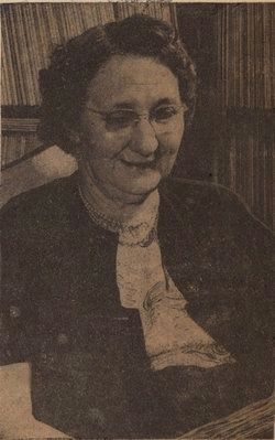
On East Hunter Street (Route 93) at North Culver Street and Zanesville Avenue, on the right when traveling west on East Hunter Street.
Born in 1886 on a farm near Logan, Tessa Sweazy Webb was a teacher at the Hocking County Children’s Home where she began writing poetry. By 1924 she had become well known across the state and nation for her published works. Under Webb’s successful . . . — — Map (db m11550) HM
On Falls Street (Ohio Route 93) just south of South Mulberry Street ( Route 93), on the right when traveling south.
Known as the Norwegian Count, Nils Louis Christian
Kachelmacher was born in Oslo, Norway of wealthy
parentage. He immigrated to the United States at age
21 and was responsible for industrial growth in the
Hocking Valley and expansion of the town . . . — — Map (db m119652) HM
On Dupler Road 0.8 miles east of Mill Road, on the left when traveling east.
Side A:
The twelfth lock on the Hocking Canal, the Sheep Pen lock, underscores Southeast Ohioans' efforts to open their region to the world during the mid-nineteenth century. Built as a guard lock, it was intended to permit slackwater . . . — — Map (db m202657) HM
On Ohio Route 56, on the left when traveling west. Reported missing.
Modern roads often have their precedents in much older thoroughfares. Two ancient paths once converged near this point. As late as the 1700s, the Salt Trail guided Native Americans from the upper Scioto Valley plains past Cantwell Cliffs, Cedar . . . — — Map (db m218379) HM
On West Main Street at Water Street, on the left when traveling south on West Main Street.
Buckeye Trail was proposed in an article in 1958 by a man named Merill Grilfilan. His hopes were that the trail would serve as encouragement to young people to learn about their native land. Several people liked this idea, and met about how the . . . — — Map (db m250997) HM
Charcoal iron production in Ohio was centered in the Hanging Rock Iron Region, a geographical area extending from Hocking County to the Ohio River and including portions of Northern Kentucky. The region encompassed an 1800 square mile area that was . . . — — Map (db m26472) HM
On East 11th Avenue at Essex Avenue, on the right when traveling north on East 11th Avenue.
A geologic cross section depicts the distribution of rock layers in Ohio as being like the layers of a cake. This cross section traverses from the Ohio-West Virginia boundary at Belpre, Ohio, to Bellefontaine, then to the Michigan-Indiana-Ohio . . . — — Map (db m280879) HM
On Buckeye Park Road (Local Road 167) at Buckeye Road (Local Road 165) on Buckeye Park Road. Reported permanently removed.
Charcoal iron production in Ohio was centered in the Hanging Rock Region, a geographic area extending from Hocking County to the Ohio River and including portions of northern Kentucky. The region encompassed an 1800 square mile area that was rich . . . — — Map (db m26428) HM
On Buckeye Park Road (County Road 167) just north of Buckeye Road (County Road 165), on the left when traveling north.
Charcoal iron production in Ohio was centered in the Hanging Rock Region, a geographic area that extends from Hocking County to the Ohio River and includes portions of northern Kentucky. The region encompassed a 1,800 square mile area that was . . . — — Map (db m158856) HM
On Ellisonville-Paddle Creek Road at Sugar Creek Ridge-Vesuvius Road, on the right when traveling east on Ellisonville-Paddle Creek Road.
Vesuvius Iron Furnace is one of 69 charcoal iron furnaces in the Hanging Rock Iron Region. This 100-mile long region extends from Greenup County, Kentucky to Hocking County, Ohio. Built in 1833, Vesuvius began production using the cold blast . . . — — Map (db m309340) HM
Thin black lines indicate changes in relevance. Between each pair of lines entries are ordered geographically but all have the same relevance.
* Inflectional forms of words are their plurals, singulars, and possessives as well as gramatical tenses and similar variations.