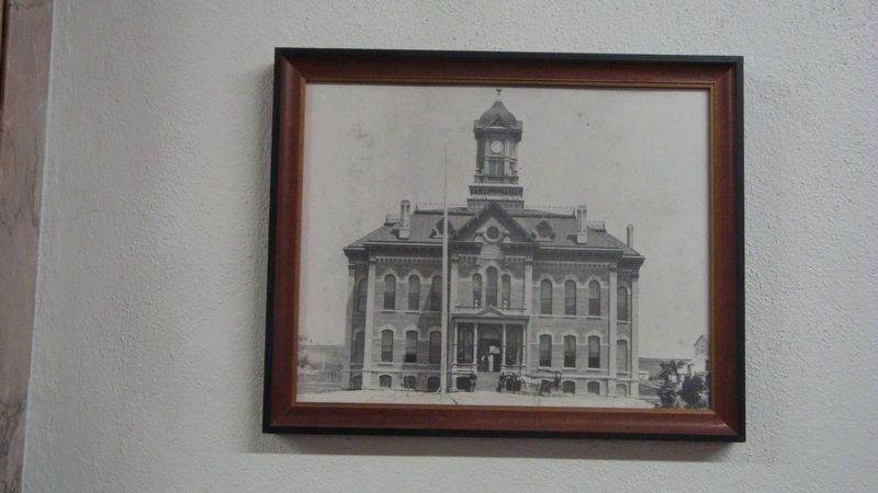
Near East Capitol Avenue at S. Pierre Street, on the right when traveling north.
The Old Hughes County Courthouse—South Dakota’s Temporary Capitol
The old Hughes County Courthouse, shown at left, was erected in 1883 and served an important role in the formation of the new South Dakota government in 1889. It was replaced . . . — — Map (db m157519) HM
On North Euclid Avenue (U.S. 83) south of East Prospect Avenue, on the left when traveling north.
Hughes County Courthouse (marker side 1)
The Hughes County Courthouse was built and occupied in February 1935, to replace the original 1883 brick structure. The new Courthouse was designed by architects Hugill and Blatherwick of Sioux . . . — — Map (db m124269) HM
Flowing just north of here, Medicine Creek runs through the center of Lyman County, emptying into the Missouri River 27 miles (43 kilometers) to the northeast. The place-names of this Central South Dakota area read like an index to early state . . . — — Map (db m184639) HM
On Interstate 90 at milepost 221, on the right when traveling west.
Flowing just north of here, Medicine Creek runs through the center of Lyman County, emptying into the Missouri River 27 miles (43 kilometers) to the northeast. The place-names of this Central South Dakota area read like an index to early state . . . — — Map (db m192318) HM
On East Wells Avenue west of South Washington Avenue, on the right when traveling west.
Coe Isaac Crawford was born on January 14, 1858 on a farm near Volney, IA. Growing up, he worked nine months out of the year and attended school only in the winter months. At age 15 he left home to attend school fulltime in the neighboring town of . . . — — Map (db m220039) HM
On South Poplar Avenue, on the right when traveling south.
September 23, 1804 Medicine Knoll
September 24, 1804 Fischers Lilly Park
September 25, 1804 Stanley Road & Yellowstone Street
September 26-27, 1804 Oahe Campground #3
White Gull drawing from Merriweather . . . — — Map (db m246375) HM
On South Pierre Street at Island View Drive when traveling south on South Pierre Street.
This American Flag
is flown to honor American Veterans of All Wars and in memory of
Walter H. Burke,
a Past State Commander (1927-1938) and Past Post Commander (1927-1928)
of the Pierre Post No. 8, Department of South . . . — — Map (db m124286) WM
Near 264th Street 0.5 miles west of 484th Avenue (County Road 109), on the left when traveling west.
The Samuelson Family
Dakota Pioneers
John A. Samuelson was born in Sweden in 1837. He immigrated to the United States in 1868 and lived for one year in Iowa. In 1869, he came to Dakota Territory and filed on a homestead of 160 acres, . . . — — Map (db m222435) HM
Thin black lines indicate changes in relevance. Between each pair of lines entries are ordered geographically but all have the same relevance.
* Inflectional forms of words are their plurals, singulars, and possessives as well as gramatical tenses and similar variations.