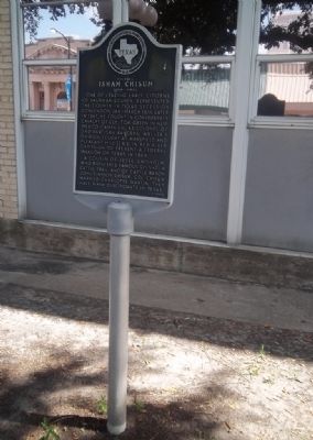
On West Grove Street at North Washington Street, on the left when traveling east on West Grove Street.
One of leading early citizens of Kaufman County. Represented the county in Texas Secession Convention, Jan.-March 1861. Later in 1861, he fought in Confederate cavalry of Col. Tom Green in New Mexico campaign. As Colonel of 2nd Partisan Rangers, . . . — — Map (db m201872) HM
On East 5th Street, on the right when traveling east.
Artist Frank Reaugh (1860-1945), who immortalized the Texas longhorn, began sketching and studying his favorite subject in 1876 when he and his parents, George W. and Clarinda Reaugh, moved from Illinois to Kaufman County. He studied art in St. . . . — — Map (db m152520) HM
On Ranch to Market Road 187 1 mile north of Waresville Cemetery Road, on the left when traveling north.
Capt. William Ware was born in 1800 to Joseph and Elizabeth Ware in Kentucky (Georgia in some sources). In 1828, he and his wife, Ann Murphy, and their three children moved to Montgomery County, Texas. From there, Ware raised a military company in . . . — — Map (db m155556) HM
On Railroad Street at Ennis Street, on the right when traveling south on Railroad Street.
Originally known as Trinidad, Rosser depended on the Trinity River for trade until 1882, when a line of the Houston and Texas Central Railroad was built here. The company was later renamed the Texas Midland Railroad by Mrs. Hetty Green of New York, . . . — — Map (db m95805) HM
On West Denton Street at North Sherman Street, on the right when traveling west on West Denton Street.
Built in 1905 for Malinda (Anderson) and Hardin T. Moore, this Neoclassical Revival house is a significant part of Ennis' architectural history. The Moores married in 1892, after both Malinda and Hardin had been widowed in previous marriages. They . . . — — Map (db m164757) HM
Henry McKinney (1863-1936) was born in Kemp, Kaufman County and, at the age of 20, enlisted in Company C of the Frontier Battalion of the Texas Rangers. After one year, McKinney was discharged and returned to Kemp. He married Viola Dorsey . . . — — Map (db m191318) HM
On South Buffalo Street (State Highway 198) south of East Dallas Street (State Highway 64), on the left when traveling south.
John Henninger Reagan was born in 1818 to Timothy Richard and Elizabeth Reagan in Sevier County, Tennessee. He worked at his father's tannery and on the family farm, attending school sporadically, until leaving the state in 1838.
Reagan came in . . . — — Map (db m54002) HM
On South Main Street south of West 9th Street, on the right when traveling south.
This community can trace its origins to 1851, when the U.S. Postal Service approved a station named Kemp with Levi Noble as first postmaster. In the years prior to the Civil War, Kemp was primarily an agricultural community, providing goods and . . . — — Map (db m95900) HM
First settled in the 1840s, this region was a part of Kaufman County until 1873, when Rockwall County was created. With an area of 147 square miles, this is the smallest of Texas' 254 counties. The county and city of Rockwall were named for an . . . — — Map (db m212615) HM
On County Road 4525 north of County Road 4528, on the left when traveling north.
In 1902 Alabama native Isaac Newton "Newt" Gresham was a Rains County farmer and newspaper editor. Wishing to help local farmers organize to take advantage of farm prices, he called a meeting in a nearby barn that summer. With an initial membership . . . — — Map (db m280143) HM
On North Trade Days Boulevard 0.1 miles north of East Dallas Street (State Road 19), on the right when traveling south.
In 1867, a group of citizens, resentful of Northern control of the State and county, attempted to secede from Texas and the U.S. General Philip Sheridan, Commander at New Orleans, sent federal troops to restore order – resulting in a battle, won by . . . — — Map (db m247165) HM
On East Evans Road 0.1 miles east of Nacogdoches Road, on the right when traveling east.
William Davenport was born in 1820 in Saltville township, Virginia. His family later lived in Kentucky before settling in present-day Kaufman County, Texas in 1843. There William met and married Mary Ware, daughter of Texas Revolutionary veteran . . . — — Map (db m195451) HM
On Fulton Avenue south of 6th Street, on the right when traveling south.
Isham Tubbs (1852-1947) married Texana Spikes (1857-1930) in Kaufman County in 1877. They moved to the Monterey area of Lubbock County circa 1890. Isham became one of the first school board trustees and a charter member of Lubbock's first United . . . — — Map (db m73611) HM
On Farm to Market Road 182 south of County Road 4195, on the left when traveling north.
The first Norwegian immigrants to Bosque County arrived in 1854. As the number of Norwegian settlers increased after the end of the Civil War, most families continued the rural farming traditions practiced in their homeland. The commercial and . . . — — Map (db m283683) HM
On Madeley Avenue at Tamm Street, on the right when traveling west on Madeley Avenue.
James Henry Dishman was forced at the age of six to assume a man's role after his father's death in the Civil War in 1864. A native of Cherokee County in East Texas, he eventually moved to Kaufman County and developed a successful ranching . . . — — Map (db m261719) HM
On Oak Creek Drive (U.S. 175 Frontage Road) 0.1 miles north of Climbing Tree Drive, on the left when traveling north.
William and Nancy Kirk Love and their children were the earliest settlers near King's Fort, establishing themselves there in January 1845. Their son, Robert H. Love, is believed to have been the first person interred on this site upon his death in . . . — — Map (db m95808) HM
On South Adelaide Street at S Aly Road, on the left when traveling south on South Adelaide Street.
A number of early landowners in Kaufman County contributed to the progress of the railroad and the development of the City of Terrell. Two central figures are John G. Moore (1826-1880) and Charles C. Nash (1833-1878), both originally from . . . — — Map (db m305673) HM
On East Broad Street at South Virginia Street (Texas Highway 34), on the right when traveling west on East Broad Street.
Founded in 1873, the town of Terrell was located on the route of the Texas & Pacific Railroad. Robert A. Terrell, for whom the town was named, was a surveyor and landowner in Kaufman County. Portions of land were given to the Texas & Pacific by the . . . — — Map (db m97643) HM
On Farm to Market Road 219 at Farm to Market Road 182, on the left when traveling east on Road 219.
Though never as numerous as some national groups emigrating from Europe, Norwegians left an imprint on rural life in Texas.
Hundreds sailed to the United States beginning in the 1830's. For those who settled in Texas, Bosque County had great . . . — — Map (db m283688) HM
On South Center Street south of East Main Street, on the right when traveling south.
Duncan Graham McKellar and his wife Emma (McCullough) McKellar built this house in 1886. The McKellars were integral to the economic, social, and religious development of Forney and Kaufman County in the years between 1886 and 1903. The home's . . . — — Map (db m255890) HM
Near South Houston Street (County Route 1388) 0.3 miles south of South Washington Street (Texas Highway 34), on the right when traveling south.
As did many Texas counties of the era, Kaufman County created a poor farm in 1883 in order to provide the indigent residents and families of the area with food, shelter, and medicine. This work program replaced earlier relief efforts. All . . . — — Map (db m95807) HM
On West Grove Street at North Jackson Street, on the left when traveling west on West Grove Street.
Wife of founder of King's Fort (in 1840), Frances A. King pioneered with great courage and enthusiasm in Republic of Texas. After King's death in 1846, she later (as Mrs. Tabor) entered and won election of Kingsborough for county seat of newly . . . — — Map (db m96208) HM
A dispensation for the formation of the lodge was granted July 26, 1854, when Rockwall was part of Kaufman County. The Grand Lodge of Texas designated James Wilson as the first master. John O. Heath served as senior warden and S. R. Barnes as . . . — — Map (db m212618) HM
Born in Kaufman County, William "Gooseneck Bill" McDonald became active in politics in 1890. His ability to unite Black and White voters led to his prominence as a leader of the "Black and Tan" faction of the Republican party. He remained . . . — — Map (db m264164) HM
On North Main Street at W Elm St, on the right when traveling north on North Main Street.
Adolphus Lane Spradlin (1863-1946) came to Texas from Indiana in 1875 with his parents. He settled at Hiram in Kaufman County and married Lee Ann Henson (1864-1939), of Cherokee ancestry. In 1898 he bought land in the Van Zandt County community of . . . — — Map (db m245164) HM
On Vista Lane at Five Points Drive, on the right when traveling west on Vista Lane.
This burial ground is part of 600 acres purchased for use as a poor farm operated by Kaufman County beginning in 1883. It is the final resting place for some of Kaufman County's citizens who were poor farm residents, county jail inmates, paupers, . . . — — Map (db m95806) HM
On Interstate 30 Frontage Road 0.2 miles Division Street, on the right when traveling west.
Majors Field in Greenville became the site of a major source of manufacturing following WWII. In 1951, the city secured a contract to lease some of the field to Texas Engineering and Manufacturing Company (TEMCO). Thus began Majors Field's new life . . . — — Map (db m285497) HM
On West Pyle Street at North Clay Street, on the left when traveling west on West Pyle Street.
An early frontier fort of the Republic of Texas, King's Fort was built in June of 1840 by a survey party led by Warren A. Ferris, then Nacogdoches County surveyor. Dr. William P. King of Mississippi financed the expedition and accompanied Ferris. . . . — — Map (db m96207) HM
On West Erwin Street east of North College Avenue, on the left when traveling east.
At a time of low crop production and depressed farm economy, Smith County became the birthplace of the County Agricultural Agent concept. This occurred in an historic meeting Nov. 12, 1906, in an opera house near this site. Present were Dr. . . . — — Map (db m91382) HM
The city of Terrell was founded in 1873. C. M. Bivens, John H. Corley, and F. A. Waters opened a private bank here in 1875. In 1878, Asa Holt replaced Waters as one of the owners. Later the enterprise became the Bivens and Corley Bank and moved to . . . — — Map (db m98116) HM
Thin black lines indicate changes in relevance. Between each pair of lines entries are ordered geographically but all have the same relevance.
* Inflectional forms of words are their plurals, singulars, and possessives as well as gramatical tenses and similar variations.