On Main Street (Jefferson Davis Memorial Highway) at Norwood Street, on the left when traveling west on Main Street (Jefferson Davis Memorial Highway).
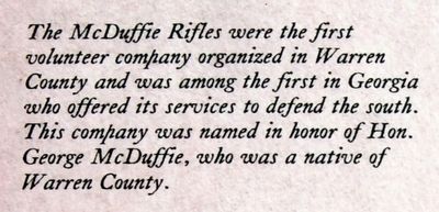
The McDuffie Rifles were the first volunteer company organized in Warren County and was among the first in Georgia who offered its services to defend the south. The company was named in honor of Hon. George McDuffie, who was a native of Warren . . . — — Map (db m90450) HM
On Main Street near Norwood Street, on the right when traveling west.
The second company from Warren County met under the Oak Tree in the corner of the Methodist Churchyard. They boarded the mule car at the station where the church now stands and were drawn to Camak where they entrained for Augusta. The company was . . . — — Map (db m90443) HM
On Main Street (Business Route 278) at West Gibson Street, on the right when traveling east on Main Street.
This County, created by Act of the Legislature Dec. 19, 1793, is named for Gen. Joseph Warren, Massachusetts Revolutionary hero killed at the Battle of Bunker Hill. What is claimed to have been the first iron works and woolen mill in Georgia was . . . — — Map (db m49372) HM
On Court Square at Norwood Street, on the right when traveling west on Court Square.
[Center Panel]:
The Formation of and Changes in the Warren County Boundary Line
Warren County was created by an Act of the Legislature on December 19, 1793. Parts of the counties of Richmond, Columbia, and Wilkes were taken to form . . . — — Map (db m90436) HM
On Court Lord Highway (State Highway 112) 1 mile south of Liberty Church Road, on the right when traveling north.
Near this site is the plantation and grave site of John Hatcher, Georgia patriot, Revolutionary War soldier and statesman. From 1780 to 1800 he served in Candler’s Refugee Regiment of Richmond County, the Georgia Militia, Carr’s Rangers of Burke . . . — — Map (db m13080) HM
On West Broad Street (Georgia Route 37) at North Court Avenue, on the right when traveling west on West Broad Street.
The county was created by an Act of the Georgia Legislature on Dec. 21, 1857. Some historians say that the county was named for David B. Mitchell, Governor of Georgia in 1809-13 and again in 1815-17, and that Camilla was named for his daughter. . . . — — Map (db m27094) HM
On East Main Street at Palmer Street, on the right when traveling east on East Main Street.
This County, created by Act of the Legislature Dec. 19, 1857, is named for Gen. Thomas Glascock who served in the War of 1812 and the Seminole War. He was a Speaker of the Georgia House of Representatives and a Member of Congress from 1835 to . . . — — Map (db m55549) HM
On Springfield Road 0.1 miles north of Spingfield-Log Cabin Road, on the left when traveling north.
Zack Hubert, a former Warren County slave, moved here with his family in 1871. The Huberts were among the first African-American landowners in central Georgia and played influential roles in the area's African-American community. They named their . . . — — Map (db m49413) HM
On Main Street (County Route 113) east of Warren Street, on the left when traveling east.
A great American hero
and the namesake of Mitchell, GA.
Graduated Lynchburg Military College
Joined the Confederate Army as a Lt. on Apr. 22, 1861, at age 16, Army of Northern VA; Langhorne’s Corp.; Pickett’s Div.;
Longstreet’s Brigade; . . . — — Map (db m61364) HM
To Arms !
The 800 stones before you have three meanings:
› They represent the approximate number of
soldiers killed or wounded in Savannah on the
foggy morning of October 9, 1779.
› The stones are arranged as a . . . — — Map (db m17362) HM
On Main Street (Jefferson Davis Memorial Highway) at Norwood Street on Main Street (Jefferson Davis Memorial Highway).
First National Flag (Stars and Bars)
The first official flag of the confederacy was the Stars and Bars, and was reported to the provisional congress of the C.S. by the flag committee on March 4, 1861. It appears to have not had a recorded . . . — — Map (db m90441) HM
On Appling Harlem Road (US 221,State Road 47) near Shucraft Road, on the left when traveling north.
Columbia County, named for Christopher Columbus, was created by Act of Dec. 10, 1790 from Richmond County. Originally, it contained parts of McDuffie and Warren Counties. Settled by Quakers before the Revolution, it has been the home of many . . . — — Map (db m27049) HM
On Wright Avenue at East Agency Street, in the median on Wright Avenue.
[south panel]Erected in 1931 by the United States Government to commemorate the life and public service of Colonel Benjamin Hawkins who was born in Warren County, N.C. August 15, 1754 and died at the Creek Indian Agency on . . . — — Map (db m186672) HM
Beall Cemetery, located in the Young Perry Alsbury Survey, began as a family burial ground on the farm of early settlers Erasmus (Erastus) and Elizabeth Brinkley Beall, parents of six sons and four daughters. The Beall family migrated to Texas . . . — — Map (db m205671) HM
On North 22nd Street 0.1 miles north of East Main Street (U.S. 84), on the right when traveling north.
Born in Warren County, Ohio, to Asahel C. and Meeky (Bobo) Bates, John Calhoun Bates completed his medical study at the Eclectic Medical Institute in Cincinnati, Ohio, in 1850. He then moved to Florida where he began practicing medicine. Dr. Bates . . . — — Map (db m217499) HM
On West Barbour Street, on the left when traveling west.
Built between 1856 and 1860 by Edward Brown Young and his wife, Ann Fendall Beall, this was one of the first of the great Italianate style homes constructed in Eufaula. It later became the home of the builders’ daughter, Anna Beall Young, and her . . . — — Map (db m33759) HM
Near Dismal Hollow Road (Virginia Route 647) 0.4 miles north of John Marshall Highway ( Route 55), on the right when traveling west.
The last engagement of the Gettysburg Campaign took place here in Manassas Gap on July 23, 1863. Union Gen. George G. Meade and the Army of the Potomac pursued Confederate Gen. Robert E. Lee's Army of Northern Virginia as it retreated south through . . . — — Map (db m133606) HM
On West Gibson Street at Main Street, on the right when traveling south on West Gibson Street.
(Main Inscription:)
Memorial
Avenue
——
Dedicated to the
memory of the sons
and daughters of
Warren County who
gave their lives for
their country in the
Great Worlds War.
Edmond B. Bacon
Thos. W. Duckworth
Wm. . . . — — Map (db m288051) WM
Near Capitol Avenue Southwest south of M.L.K. Junior Drive Southeast, on the left when traveling north.
Expelled Because of Color” is dedicated to the memory of the 33 Black state legislators who were elected, yet expelled from the Georgia House because of their color in 1868.
The cinder block forms at the base of the sculpture symbolize the . . . — — Map (db m130191) HM
[Header]
Walkable Warren
Walkable Warren is a local initiative intended to promote healthy lifestyles by encouraging foot traffic and bicycling as alternative modes of travel in and around the City of Warren. Warren has a wealth of . . . — — Map (db m307083) HM
Thin black lines indicate changes in relevance. Between each pair of lines entries are ordered geographically but all have the same relevance.
* Inflectional forms of words are their plurals, singulars, and possessives as well as gramatical tenses and similar variations.