On Williams Road at Gerlaugh Drive, on the left when traveling east on Williams Road.
The Ohio General Assembly established the Ohio Agricultural
Experiment Station in 1882. From its inception until 1892, the
Station occupied 17 acres on the Columbus campus of The Ohio
State University before relocating to 470 acres in Wayne . . . — — Map (db m131935) HM
On Carmack Road 0.2 miles north of West Lane Avenue, on the right when traveling north.
The Ohio General Assembly established the Ohio Agricultural Experiment Station in 1882. From its inception until 1892, the Station occupied 17 acres on the Columbus campus of The Ohio State University before relocating to 470 acres in Wayne County. . . . — — Map (db m46136) HM
On East Bowman Street east of Beall Avenue, on the left when traveling east.
General Reasin Beall Homestead. Built in 1816 by General Reasin Beall and his wife
Rebecca Johnston Beall, the homestead is recognized as the oldest existing residence in the City
of Wooster. Born in 1769 in Maryland, Reasin Beall
came to . . . — — Map (db m131949) HM
Near Oldman Road (County Route 420) at Oak Hill Road, on the right when traveling west.
Charles W. Follis was born on February 3, 1879, in Virginia. His family moved to Wooster where he attended Wooster High School and helped establish the school’s football team. In 1901, Follis enrolled and played baseball at the College of Wooster . . . — — Map (db m225420) HM
On Baltimore Pike (State Highway 97), on the right when traveling north.
(Front):4th Ohio Infantry. 1st Brigade, 3rd Division, 2nd Corps. Carroll's Brigade. Ohio's Tribute. (Left):On the evening of July 2, 1863. Carroll's Brigade was sent from its position with the 2nd Corps to re-enforce this position of . . . — — Map (db m16945) HM
On 8th Street at Oak Street (U.S. 60), on the right when traveling south on 8th Street.
Ceredo Early History
Founded in 1857 by Massachusetts congressman Eli Thayer, Ceredo was the Nation's only attempt to form an abolitionist community in the old South. As a pre-War industrial town Ceredo was beginning to thrive, but with . . . — — Map (db m291707) HM
On West Franklin Street at South Main Street, on the right when traveling west on West Franklin Street.
The Indiana General Assembly authorized the formation of Randolph County from Wayne County in January 1818 to take effect in August 1818. Early historians contend that the county's name came from settlers who relocated from Randolph County, North . . . — — Map (db m225004) HM
On Ohio Turnpike (Interstate 80 at milepost 197), 3 miles east of Painesville Ravenna Road (Ohio Route 44), on the right when traveling west.
The Underground Railroad
The Underground Railroad was neither underground nor a railroad, but a system of loosely connected safe havens where those escaping the brutal conditions of slavery were sheltered, fed, clothed, nursed, concealed, . . . — — Map (db m189183) HM
The Underground Railroad
The Underground Railroad was neither underground nor a railroad, but a system of loosely connected safe havens where those escaping the brutal conditions of slavery were sheltered, fed, clothed, nursed, concealed, . . . — — Map (db m207605) HM
On Chase Street 0.1 miles north of Shawnee Street, on the left when traveling north.
William J. Knight
William J. Knight (1837-1916) was born in Wayne County, Ohio and raised by his grandparents, Jacob and Martha Knight, near Farmer, Ohio. After the outbreak of the Civil War, William enlisted in Company E, 21st Ohio . . . — — Map (db m225421) HM
On Williams Road just east of Gossard Drive, on the right when traveling east.
Barnhart Rice Homestead
The Barnhart Rice house is one of two original farmhouses occupying this 320-acre hilltop farmstead from the early days of the settlement. Started in the spring of 1822, the house was built of hand-cut sandstone . . . — — Map (db m66463) HM
On State Street (U.S. 89) at the road to Mount Carmel Cemetery, on the left when traveling north on State Street.
In memory of Isaac Behunin,
Mormon Pioneer, Early Utah Settler and
Credited with the naming of Zion Canyon
Early Mormon Pioneer
Isaac Behunin was born October 20, 1803 in Richland, New York to Albert and Nancy Lord Bohanan (Bohannon). . . . — — Map (db m40465) HM
On Kanawha Boulevard (U.S. 60) at Florida Avenue, on the right when traveling east on Kanawha Boulevard.
In July 1861, this area swarmed with retreating Confederate troops and pursuing Federal forces. Union Gen. George B. McClelland had ordered Gen. Jacob Cox to march his 3, 000 raw Ohio recruits into western Virginia from Gallipolis, Ohio, to drive . . . — — Map (db m59146) HM
On Lexington Avenue (U.S. 42) at Middle Bellville Road, on the right when traveling north on Lexington Avenue. Reported missing.
General Hedges was born in Ohio County, Virginia
and taught school in that state before coming
to Ohio in 1803. As a Deputy Surveyor, he worked
in Ashland, Holmes, Knox, Medina and Wayne Counties,
and purchased 19,000 acres in future . . . — — Map (db m284670) HM
On West Main Street at South High Street, on the right when traveling east on West Main Street.
School
The citizens of Jeromesville have always taken a great interest in their youth and they have gone to great lengths to provide them with proper training. For many years, the chil- dren of Jeromeville attended school in . . . — — Map (db m298167) HM
Wooster and Wayne County are extremely fortunate to have this quiet, wooded, 325-acre park. Wooster Memorial Park was created through the vision of Paul S. Spangler (1900-1986), a Wooster native and Wooster High School teacher. Mr. Spangler long . . . — — Map (db m241062) HM
On West Washington Street at Senate Avenue, on the right when traveling west on West Washington Street.
An Important Road
The National Road is a true American icon, conceived by George Washington, authorized by Thomas Jefferson, and traveled by Abraham Lincoln.
In 1806 construction of the National Road was approved by the US Congress to . . . — — Map (db m232658) HM
On Michigan Avenue 0.1 miles east of Capital Avenue Southwest, on the right when traveling north.
Erastus Hussey Stationmaster
Erastus Hussey came to Michigan from New York State in 1824 and purchased land in Wayne County. Hussey returned to New York for a time, but in 1839 he and his wife, Sarah, purchased a building located about 125 . . . — — Map (db m177310) HM
On East Broadway Street at 3rd Avenue, on the right when traveling west on East Broadway Street.
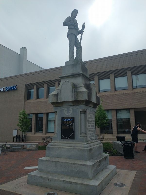
The residents of Wayne County supported the Union almost unanimously until the fighting began. After the Confederate bombardment of Fort Sumter in April 1861, the majority in the northern portion of the county shifted their allegiance to the . . . — — Map (db m83160) HM
Erected by Mr. and Mrs. Jacob Frick in honor of the Union soldiers of Wayne County, Ohio and presented to the City of Wooster May 5, 1892.
(plaque on west face) (Known) deceased Revolutionary War Veterans buried in Wayne County . . . — — Map (db m132008) WM
On Hackett Road east of Kidron Road (County Route 52), on the right when traveling east.
In the summer of 1819 settlers from Sonnenberg in
the Jura Mountains of Canton Bern, Switzerland,
arrived in Wayne County, Ohio. They fled the
religious persecution they endured because of their
Anabaptist Mennonite beliefs, including adult . . . — — Map (db m132020) HM
On West Liberty Street at South Market Street, on the right when traveling east on West Liberty Street.
These twenty pounder Parrott guns belonged to the United States Battleship Pensacola. Mounted in memory of Given Post, No. 113, G.A.R., Wooster, and dedicated to the soldiers, sailors and noble patriotic women of Wayne County, Ohio, July 4, . . . — — Map (db m131975) HM
On West Liberty Street (Ohio Route 302) at North Market Street, on the right when traveling west on West Liberty Street.
In recognition of
the patriotism of
the people of
Wayne County
who oversubscribed their
war savings quota in 1918
this tablet is
gratefully erected by the
Ohio War Savings Committee — — Map (db m221806) HM
Near U.S. 67 0.2 miles south of County Road 221, on the right when traveling south.
(First Panel): Memory Lane
Welcome to Old Greenville national Historic Site. Because of its historical and archaeological significance, the old town of Greenville was listed on the National Register of Places in March of 1990. Today, . . . — — Map (db m183644) HM
Polley Freedom Case.
In 1850, eight freed slaves of the
Polley family were kidnapped from
Ohio and sold back into slavery.
William Ratliff of Wayne County
bought four of the children. A suit
for freedom brought on their behalf
was not . . . — — Map (db m178274) HM
Thin black lines indicate changes in relevance. Between each pair of lines entries are ordered geographically but all have the same relevance.
* Inflectional forms of words are their plurals, singulars, and possessives as well as gramatical tenses and similar variations.