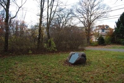
On Donald Road at Pennsylvania Route 18, on the right when traveling north on Donald Road.
This stone marks the site of the former Moravian Indian village of Languntoutenunk, or Friedensstadt, or city of Peace. Settled by the Moravian Indians in the spring of 1770. The majority of the members of this Mission had formerly belonged to the . . . — — Map (db m49396) HM
On Main Street at Mallarnee Road, on the right when traveling west on Main Street.
This ridge road west from Cadiz through Deersville to the Tuscarawas Valley is known locally as the Moravian Trail. Originally an Indian path, it became an important trail for the frontiersmen. The men who participated in the Gnadenhutten Massacre, . . . — — Map (db m79828) HM
Near South Cherry Street 0.2 miles south of West Indian Street.
Gnadenhutten
The Moravian Church in America began missionary work among the Delaware and Mohican tribes of North America in the mid-18th century. David Zeisberger, one of the best-known Moravian missionaries, came to the Ohio country with . . . — — Map (db m224977) HM
On East High Avenue (County Route 259), on the right when traveling south.
Schoenbrunn Schoolhouse 1772
In December 1772, Brother David Zeisberger and his followers began the construction of Schoenbrunn schoolhouse. The school was built in the Tuscarawas Valley on land given to Zeisberger in the spring of 1771 by . . . — — Map (db m73218) HM
On Commercial Avenue SE (Ohio Route 416) south of Cookson Avenue SE, on the left when traveling south.
Here, on April 10, 1779 during the Revolutionary War, David Zeisberger founded one of the five Delaware Christian missions to occupy the Tuscarawas Valley between May 3, 1772 and September 8, 1781. Living at the Lichtenau mission near the Delaware . . . — — Map (db m295) HM
On U.S. 36 at Salem Park Road (Local Route 213), on the left on U.S. 36.
Here, on April 6, 1780 during the American Revolutionary War, a contingent of Delaware Christian Indians, led by John Heckwelder, an assistant to Moravian missionary David Zeisberger, founded the last of five missions to occupy the Tuscarawas Valley . . . — — Map (db m296) HM
On East Wyandot Avenue, on the right when traveling east.
[Front Side]
George Washington and Col. Crawford's friendship began while Washington was acting surveyor for Lord Fairfax in the Shenandoah Valley in 1749, and continued until Col. Crawford's death.
Col. Crawford's record is as . . . — — Map (db m21386) HM
On Ohio Route 199 at County Route 29, on the left when traveling north on Ohio Route 199.
Burning of Crawford
»»««
One-half mile northeast,
June 11, 1782, the Indians
burned Colonel William Crawford
at the stake, in revenge for
massacre of the Christian
Moravian Indians by William-
son's earlier . . . — — Map (db m20362) HM
On State Highway 199 at County Highway 29, on the left when traveling north on State Highway 199.
(center plaque)
Dedicated in memory of Col. Wm. Crawford who was born in 1722, in what is now Berkeley County, West Virginia, and was burned at the stake, one half mile northeast of here down in the valley, on June 11, 1782, by the . . . — — Map (db m221839) HM
On County Route 29 at Township Highway 300, on the right when traveling east on County Route 29.
Colonel William Crawford
Colonel William Crawford, a lifelong friend of George Washington, was born in Virginia in 1722. He was married twice, first to Ann Stewart and later to Hannah Vance. In 1755, he served with Colonel Edward Braddock in . . . — — Map (db m193001) HM
On Longwoods Road (Provincial Highway 2) east of Victoria Road (Provincial Highway 21), on the right when traveling east.
The Moravians or "Bohemian Brethren" were a protestant sect that originated in the 1400s in Moravia and Bohemia, the present day Czech Republic. They faced persecution in their homeland and in 1722 many moved to Saxony (now part of Germany) where . . . — — Map (db m72448) HM
On Longwoods Road (Provincial Highway 2) east of Victoria Road (Provincial Highway 21), on the right when traveling east.
Robert McAfee, a soldier in Colonel Johnson's Mounted Regiment, kept a journal of his experiences, and wrote on October 7, 1813:
Spent the day in collecting in plunder ... Colonel Owings Regiment of Regulars came up and took charge of the . . . — — Map (db m72414) HM
On Longwoods Road (County Route 2), on the right when traveling east.
In September 1813, during the second year of the War of 1812, the United States won control of Lake Erie, cutting British supply lines with the east and forcing the British to withdraw from the Detroit River region. Then, on October 5, . . . — — Map (db m78367) HM