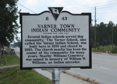
On South Live Oak Drive (Alternate U.S. 17) near Benjamin Drive, on the right when traveling north.
Varner Town (or Varnertown) is a distinct Native American community including descendants of the Etiwan, Catawba, Cherokee, Edisto and other area tribes. This community, located near Goose Creek, was named for William Varner (d. 1927) and his . . . — — Map (db m23515) HM
On Otranto Boulevard, on the right when traveling east.
Originally known as "Yeshoe," this plantation was granted in 1679 to Arthur Middleton, great-granduncle of the signer of the Declaration of Independence. Called "Otranto" after 1771, when it was bought by Dr. Alexander Garden, noted physician and . . . — — Map (db m29484) HM
On The Oaks Avenue at Middleton Drive on The Oaks Avenue.
The Oaks, an inland rice plantation, was established here by Edward Middleton (d. 1685) on a 1678 grant from the Lords Proprietors. Middleton, a planter who came to S.C. from Barbados, received 1,630 acres on Yeaman’s Creek, later renamed Goose . . . — — Map (db m29497) HM
On Old US 52 at Lewisfield Plantation Road, on the right when traveling north on Old US 52.
This land, part of Fairlawn Barony and known as Little Landing, was bought in 1767 by Sedgwick Lewis. His daughter Sarah married Keating Simons. They acquired the land in 1774 and are presumed to have built the present plantation house. Tradition . . . — — Map (db m29132) HM
Near Old US 52 at N. Mulberry Drive, on the right when traveling north.
Originally granted to Sir Peter Colleton in 1679. Acquired in 1712 by Thomas Broughton, who erected the present mansion, said to be modeled after Seaton Hall in England, in 1714. Thomas Broughton was speaker of the Commons House of Assembly from . . . — — Map (db m29130) HM
On North Main Street (U.S. 17A), on the right when traveling north.
This county was designated a court and land conveyance district in 1682, and an election district in 1683. It was named for two brothers, Lord John and Sir William Berkeley, both Lord Proprietors of Carolina. Over the years, functions of this early . . . — — Map (db m22948) HM
Built by Henry Middleton on land bought from Elias Earle in 1813, Whitehall served as his summer home until 1820 when it was sold to George W. Earle, whose descendants have occupied it ever since. Henry Middleton was son of Arthur Middleton, signer . . . — — Map (db m9085) HM
On Colonel Maham Drive at Westfield Drive, on the right when traveling south on Colonel Maham Drive.
Burial place of Col. Hezekiah Maham A native of St. Stephen's Parish Berkeley County, South Carolina Born 1739 Died 1789 He was a distinguished soldier and patriot of the American Revolution — — Map (db m54777) HM
On Whilden Street at Rose Lane, on the right when traveling north on Whilden Street.
On November 18, 1859, a Warrant of Constitution was granted to Etiwan Lodge No. 95 by the Most Worshipful Grand Lodge of Ancient Free Masons of South Carolina. The lodge organized under dispensation on February 19 and held their first meeting in . . . — — Map (db m36684) HM
On South Carolina Route 45 0.1 miles west of Tower Hill Plantation Drive, on the left when traveling west.
Maude E. Callen (1898-1990) was born
in Quincy, FL. She received formal
training at Florida A&M Univ. and the
Tuskeegee Institute. In 1923, she and
her husband moved to Pineville, S.C..
where she worked as an Episcopal
missionary and one of . . . — — Map (db m270288) HM
Built for Paul de St Julien in
1716 in Berkley County, S.C.
Hanover was reconstructed
on campus in 1941 and was
relocated to this site in 1994.
Listed on the National Register
of Historic Places. — — Map (db m13162) HM
On Dr. Evans Drive (State Road 8-44) near Hard Pinch Road, on the right when traveling south.
Acording to family information, Francis Marion, brigadier general of the S.C. Militia during the American Revolution, was born near here on Goatfield Plantation. He was a member of the First Provincial Congress, fought in the battles of Parker's . . . — — Map (db m22968) HM
On East Main Street at Behrman Street, on the left when traveling west on East Main Street.
Old Moncks Corner was near the intersection of Hwy 17A and Hwy 52. Old Moncks Corner was abandoned in 1856 when the North-Eastern Railroad was run from Charleston to Bonneau. A railroad depot was placed at the northwest corner of Main St. (formerly . . . — — Map (db m223939) HM
Francis Marion was born in 1732 on his family’s plantation in St. John’s parish, Berkeley County, South Carolina. Marion became famous for his highly effective use of guerilla warfare and he served as a model for the future United States Army . . . — — Map (db m104965) HM
On Main Street (Business U.S. 501) near Dozier Street, on the left when traveling west.
Born St. John’s Parish, S. C., 1732. Died February 27, 1795. Buried Belle Isle Plantation, Berkeley County, S. C.
1759 — French and Indian War 1761 — Cherokee Uprising 1775 — Captain, 2nd S. C. Regiment 1775 — . . . — — Map (db m18082) HM
On State Street (U.S. 176) at Eutaw Road (State Highway 453), on the right when traveling south on State Street.
(Front text)
This community had come into existence by 1848 near the Camden fork of the Old State Road. It was chartered in 1887 in Berkeley County, following the coming of the railroad in 1886. The town was annexed to Orangeburg County in . . . — — Map (db m22917) HM
This town, established in 1823, grew up around a store owned by Matthew Young (1803-1876), who was also postmaster 1831-43. It was first called Pressly's Station, for the post office opened in 1823 with David Pressly (1764-1834) as postmaster. The . . . — — Map (db m9397) HM
The Hanover House was built in 1716 in Berkeley County, S.C. for French Huguenot Paul de St. Julien. St. Julien honored his French heritage in the mortar of one chimney by inscribing "Pue a Pue" from the French proverb "Little by Little the bird . . . — — Map (db m64780) HM
On Stoney Landing Road, on the right when traveling east.
C.S.S. David
This Confederate vessel revolutionized the concepts of war at sea with a torpedo attack on the New Ironsides in Charleston Harbor on October 5, 1863.
Constructed on Stoney Landing Plantation, Berkeley County, . . . — — Map (db m84713) HM WM
Near Stony Landing Road east of Red Mulberry Road, on the right when traveling east.
There was a time when Fort Fair Lawn, a significant site in the struggle for American independence, was in danger of being lost forever. Indeed, a housing subdivision was proposed for this property shortly before it was acquired for . . . — — Map (db m300785) HM
On Highway 41 (U.S. 17) at Browns Chapel Road, on the right when traveling south on Highway 41.
In Memory of W. J. Andrews, Member, State Highway Commission 1932–1935.
Born in Vermont – May 20, 1873
• Settled in Georgetown – 1900
• Mayor of Georgetown
• Founded town of Andrews
• Died in Andrews – January 20, 1935 — — Map (db m269775) HM
Near Old Sheldon Church Road north of Trask Parkway, on the right when traveling north.
William Bull
of Sheldon
Born 1683 Son of Stephen Bull,
the Immigrant
Member Colonial House of Commons
1706 - 1719
Colonel of Berkeley County Regiment
Tuscarora and Yemassee Wars.
Lord's Proprietors Deputy 1719.
Member and President . . . — — Map (db m106135)
On State Street (U.S. 176) at Depot Street, on the left when traveling east on State Street.
The rural 19th Century village began as a sparsely settled community in historic St. James, Goose Creek Parish of the Charleston District. Following the revolutionary War, increased numbers of settlers entered the parish's backcountry where it . . . — — Map (db m22505) HM
On South McDuffie Street at East Reed Street, on the left when traveling south on South McDuffie Street.
Front
This Parish, organized in 1851 with the Rev. Benjamin Webb as its first vicar, grew out of occasional Episcopal services held in Anderson as early as 1844. The first church here, a frame Carpenter Gothic building, was completed in . . . — — Map (db m10417) HM
On Matilda Circle Road (State Highway 8-204) at Walnut Way, on the left when traveling south on Matilda Circle Road.
(Front text)
Pineville, established in 1793-94, was one of the first planters' retreats in the South. James Sinkler built the first summer house here in 1793. Pineville, named for its "religiously preserved" pines and known for its "sweet . . . — — Map (db m23199) HM
Thin black lines indicate changes in relevance. Between each pair of lines entries are ordered geographically but all have the same relevance.
* Inflectional forms of words are their plurals, singulars, and possessives as well as gramatical tenses and similar variations.