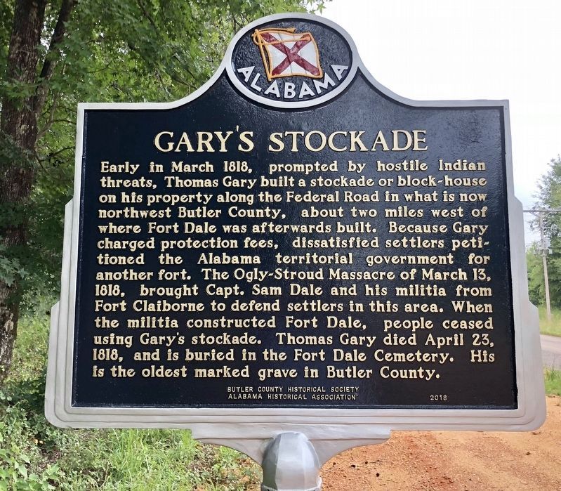
On Sherling Lake Road (Road 44) 0.4 miles north of Ridge Road (County Road 54), on the right when traveling north.
Ogly-Stroud Massacre
William Ogly built his cabin near this site at Poplar Springs along the Federal Road, and was killed here with most of his family on March 13, 1818. His friend Eli Stroud's wife was fatally wounded and their infant . . . — — Map (db m120933) HM
On Fort Dale Road (Alabama Route 185) 0.3 miles north of Sherling Lake Road, on the right when traveling south.
The Federal Road and the Palings
The Federal Road was built in 1806 as a shorter route from Washington to New Orleans and the new Louisiana Territory. The road entered Alabama at Fort Mitchell, Georgia and passed through Butler County near this . . . — — Map (db m130050) HM
On Airport Road 0.1 miles south of Old Stage Road, on the right when traveling south.
Searcy School House was built in 1922, six miles north of Greenville,
Alabama. This historic building is one of the few original wood-frame
school houses remaining in Butler County. Considered state of the art
for its day, it was built by men of . . . — — Map (db m191642) HM
On Sherling Lake Road (County Road 44) 1 mile west of Braggs Road (State Route 263), on the right when traveling west.
William Bartram, America's first great naturalist, passed through northwest Butler County in July 1775. He described the "limestone rocks" and "banks of various kinds of sea shells" left by oceans that covered this area millions of years ago, and . . . — — Map (db m120937) HM
On August 28, 1917, Alabama National Guardsmen departed from Union Station in Montgomery for shipment to France as the 167th United States Infantry Regiment of the Rainbow Division. Men from Butler County killed in action during 1918 in that great . . . — — Map (db m120940) WM
On Ridge Road (County Road 54) at Crenshaw Road, on the right when traveling north on Ridge Road.
Dr. John Coleman, born June 6, 1788 in North Carolina, was one of Butler County's earliest pioneer settlers. He built the Coleman-Crenshaw House some time between 1817 and 1821. In June 1820 the first election for Sheriff and Constable, held in . . . — — Map (db m130052) HM
On East Commerce Street (Alabama Route 10), on the right when traveling east.
The Rock Wall at Beeland Park
On this site, R.A. Beeland donated eight acres in
1933 for a recreational park. Completed in eight
months by the Civil Works Administration. Beeland
Park was dedicated on April 12, 1934. Boys and
Girl Scout . . . — — Map (db m300181) HM
On County Road 5 north of County Road 28, on the left when traveling north. Reported missing.
South Alabama Electric Cooperative’s Goshen Substation provided the first electric energy to rural Pike County. The station was energized at 11:26 A.M. on April 4, 1938. The first 86 miles of electric lines served 170 members.
The cooperative . . . — — Map (db m284359) HM
On Mobile Road (U.S. 31) 1.4 miles south of Solomon Hill Road (County Road 28), on the right when traveling south.
Early Native Americans in Butler County
Native Americans lived in the land that would become Alabama
for thousands of years before settlers arrived. They included
the Creeks, a multiethnic confederacy of tribes descended from
the . . . — — Map (db m261217) HM
On Pineapple Highway (Alabama Route 10) 0.8 miles west of Bibb Road (County Road 5), on the right when traveling west.
The Butler Massacre. On March 20, 1818, Capt. William Butler, Capt. James Saffold, William Gardener, Daniel Shaw and John Hinson left Fort Bibb to meet Col. Sam Dale. They were attacked near Pine Barren Creek by Savannah Jack and his . . . — — Map (db m83259) HM
On Monroe Street east of North Bainbridge Street, on the right when traveling east.
The Alabama Legislature approved a bill sponsored by Rep. T.E. Martin of Montgomery County in 1927 that designated the Goldenrod the official state flower. It became law on Sept. 6, 1927, the same day that the Yellowhammer became the official . . . — — Map (db m86066) HM
On East Commerce Street (Alabama Route 10) at Posey Street, on the right when traveling west on East Commerce Street.
The Camellia City
Mr. J. Glenn Stanley, an ardent camellia enthusiast, dreamed of Greenville becoming “The Camellia City” and loyally promoted this slogan as editor of The Greenville Advocate. The city’s first Camellia Show was held at . . . — — Map (db m154579) HM
The Coleman-Crenshaw House has been designated as a significant African American historic site by the Black Heritage Council of the Alabama Historical Commission. — — Map (db m299886) HM
On Parmer Street at Oglesby Street, on the right when traveling east on Parmer Street.
Butler Chapel African Methodist Episcopal Zion Church was founded in 1867
as an affiliate of the African Methodist Episcopal Zion Church. The church
is named for the first pastor, Rev. Lewis Butler, who donated the land where
the church now . . . — — Map (db m268663) HM
On East Commerce Street (Alabama Route 10) west of Flowers Street, on the left when traveling west.
The Camellia Gardens at Beeland Park
Large camellias grew prolifically all over Butler County, many
of them one hundred years old. Since the mid-1930s, Glenn
Stanley, Editor of the Greenville Advocate used the slogan
"Greenville, The . . . — — Map (db m300180) HM
Thin black lines indicate changes in relevance. Between each pair of lines entries are ordered geographically but all have the same relevance.
* Inflectional forms of words are their plurals, singulars, and possessives as well as gramatical tenses and similar variations.