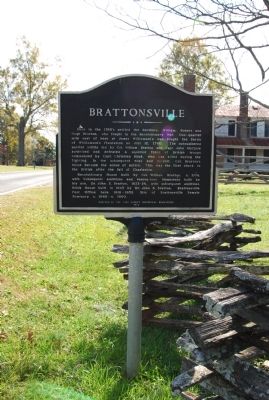
On Brattonsville Road at Percival Road, on the right when traveling south on Brattonsville Road.
Here in the 1760's settled the brothers, William, Robert, and Hugh Bratton, who fought in the Revolutionary War. One-quarter mile east of here at James Williamson's was fought the Battle of Williamson's Plantation on July 12, 1780. The . . . — — Map (db m24500) HM
On NE Cholokka Blvd (County Road 234), on the left.
The great Quaker naturalist of Philadelphia made a long journey through the southeastern states in the 1770's collecting botanical specimens. In May, 1774, he visited the Seminole Chief, Cowkeeper, at the Indian village of Cuscowilla located near . . . — — Map (db m146839) HM
On Asbury Road 0.1 miles east of Arrowhead Trail, on the right when traveling east.
This house was built in 1843 for William Thompson Nuckolls (1801-1855) and later owned for many years by John D. Jefferies (1838-1910). Built in the Greek Revival style of the antebellum period and altered in the Neo-Classical style of the . . . — — Map (db m17737) HM
On North Limestone Street (State Highway 150), on the right when traveling north.
This Classical Revival building, built in 1913-14 and designed by Arthur W. Hamby, was one of 14 public libraries built in S.C. between 1903 and 1916 with funding from Andrew Carnegie and Carnegie Foundation. A 1938 addition compatible to the . . . — — Map (db m7307) HM
The view seen beyond was a frontier pasturing ground, known locally as the Cow Pens. The name came from the custom of wintering cattle in the lush area around Thicketty Mountain.
General Daniel Morgan chose this ground for its tactical . . . — — Map (db m126716) HM
On College Drive at South Johnson Street, on the left when traveling south on College Drive.
Towne Center
This side indicates the center point for the second survey by the Town of Gaffney to expand its city limits to include all property within a one-mile radius of this location. The survey was conducted by R.O. Sams, February 27, 1890 . . . — — Map (db m44392) HM
On Union Highway (State Highway 18) south of Round Tree Road.
This plantation, 1.5 mi. S. near Thicketty Creek, was settled about 1767 by John Nuckolls, Sr. (1732-1780), a native of Virginia. During the American Revolution, as the war in the backcountry became a vicious civil war, the plantation became . . . — — Map (db m39046) HM
The Seven Branches Of Learning
Quadrivium
The higher division of the seven liberal arts in the Middle Ages, composed of geometry, astronomy, arithmetic, and music
Trivium
The lower division of the seven liberal arts . . . — — Map (db m7253) HM
Near Jenkins Road north of Underwood Road, on the left when traveling west.
South Carolina native A. J. Hood (b. 1820) migrated to Cherokee County, Texas, about 1846. Ten years later, after representing that area during two terms of the state legislature, he moved his family here. Hood opened a law office in Weatherford . . . — — Map (db m189721) HM
On North Granard Street (U.S. 29) near West Buford Street, on the right.
[Southeast Face]
Born Sept. 29,1775 in Granard,
County Longford, Ireland.
Came to Charleston S.C.
Feb. 3, 1800.
Married Miss. Polly Smith
of Smith's Ford Union County
July 21, 1803.
He established the present
site of . . . — — Map (db m272198) HM
On North Granard Street (U.S. 29) near West Floyd Baker Boulevard (State Highway 11), on the right when traveling west.
The Grindal Shoals and Cherokee Ford roads crossed here when this land was orininally granted to John
Sarratt in 1799 by the State of South Carolina. Michael Gaffney purchased the land in 1804 and by
1820 Gaffney's Tavern was located at the . . . — — Map (db m7245) HM
On North Logan Street at West Floyd Baker Boulevard (South Carolina Highway 11), on the right when traveling north on North Logan Street.
1775 - 1854
Michael Gaffney
Founder
City of Gaffney
Memorial Wall Erected 1976
by City of Gaffney
Leonard Hope, Mayor
Ben L. Clary, City Administrator
Ray Clary, Frank Guyton, Fred Kirby
John Q. . . . — — Map (db m23558) HM
On North Limestone Street (State Highway 150) at West Street, on the right when traveling north on North Limestone Street.
Michael Gaffney was born in Granard Ireland and immigrated to the United States in 1797. After a short period in New York, he set sail for Charleston, South Carolina. He departed Charleston for the upstate and arrived at Smith's Ford on the . . . — — Map (db m289121) HM
On El Bethel Church Road (State Highway 11-15) when traveling east.
The family cemetery of Lt. Col. James Steen (d. 1781), S.C. militia officer during the American Revolution, is on his plantation nearby, along Thicketty Creek. Steen, who commanded units in several campaigns from 1775 to 1781, was killed in 1781 . . . — — Map (db m44670) HM
On Chesnee Highway (State Highway 11) at Hayes Road, on the left when traveling west on Chesnee Highway.
In the winter of 1780, General Daniel Morgan moved a veteran force of American Continentals and militia into the area west of the Broad River in modern-day Spartanburg and Cherokee Counties. To counter this threat, British Commander Lord Cornwallis . . . — — Map (db m108659) HM
Near East North Loop Road 0.2 miles west of Wurzbach Parkway.
South Carolina native John "Jack" Coker came to Texas in 1834 and fought in the Battle of San Jacinto. In gratitude for his service, Coker received from the Republic of Texas a one-third league, which totalled 1,920 acres and was situated along . . . — — Map (db m177119) HM
On East Doctor L M Rosemond Lane at Courthouse Alley, on the right when traveling west on East Doctor L M Rosemond Lane.
Rufus H. Foster, Sr. 1893-1984
A native of Columbia, South Carolina, Mr. Foster was born to Williams M. and Phoebe Brown Foster. He was married to the former Henrietta Crystal Littlejohn and to their union, seven children were born. In . . . — — Map (db m252522) HM
On North Carolina Avenue just north of West Cherokee Street (State Route 11), on the left when traveling north.
Early Days The Chesnee area has a long history, despite the fact that the town itself is one of the youngest in the Spartanburg County. Like all of the upstate, the Chesnee area was once inhabited by the Cherokee Indians. The abundant old . . . — — Map (db m196934) HM
Near Elm Road 0.3 miles east of Belton Drive, on the right when traveling east.
Established about 1785, Cleveland County's oldest and most historic church cemetery contains remains of the earliest settlers from nearby communities and their descendants. Among those buried here are heroes of the Revolutionary War, the Indian . . . — — Map (db m285815) HM
On Old Number 6 Highway (State Highway 6) near Bluebird Trail, on the right when traveling south.
George Sterling was granted 570 acres of land here on March 14, 1704. During the lifetime of his daughter, Mary Sterling Heatly Russell, the plantation was a stopping place for Indians and travelers on the Cherokee Path. The Rev. John . . . — — Map (db m27218) HM
Near State Road S-11-584 0.2 miles south of Goucher School Road, on the right when traveling south.
(Preface)
Overmountain Men
After Fort Thicketty, the Overmountain Men continued to rally against Major Patrick Ferguson. On September 25, 1780, hundreds of buckskin-clad woodsmen assembled at Sycamore Shoals in present-day Tennessee . . . — — Map (db m285713) HM
On South Main Street (State Highway 124) at East Broad Street, on the left on South Main Street. Reported permanently removed.
As a tribute to his skills exploiting enemy weaknesses, Pickens became known as the "Wizard Owl" or "Skyagunsta" - a bird known for seeing clearly, acting wisely and striking quickly.
Pickens was a tall, religious Presbyterian from . . . — — Map (db m259654) HM
On Old Georgia Highway (U.S. 29) near Willis Street.
Granard Graded and High School. This is the original location of Granard Graded and High School, also known as Granard Street School. It was built here between 1905 and 1914 and included the first black high school in Gaffney. The first high . . . — — Map (db m23967) HM
On North Limestone Street (State Highway 150) at East Frederick Street (State Highway 18), on the right when traveling north on North Limestone Street.
Married June 27th, 1874.
Came to Gaffney in August, 1876.
Merchant, Banker, President of Mills,
Business Leader, Builder of Homes and
Houses of Business, Philanthropist.
This building was erected by A.N. Wood
in 1881, being from the . . . — — Map (db m7330) HM
On Asbury Road (State Highway 211), on the right when traveling west.
This African American church, the first in what is now Cherokee County, was most likely built between 1880 and 1890. It served the Whig Hill, Asbury, and Thickety communities of what was Union County before Cherokee County was created in 1897. . . . — — Map (db m19724) HM
Pacolet River Heritage Preserve, owned and managed by the S.C. Department of Natural Resources, covers 278 acres in Spartanburg County, SC. Come to bird-watch, take photographs, fish or simply enjoy the woods and Pacolet River. Leave with a sense . . . — — Map (db m55086) HM
Thin black lines indicate changes in relevance. Between each pair of lines entries are ordered geographically but all have the same relevance.
* Inflectional forms of words are their plurals, singulars, and possessives as well as gramatical tenses and similar variations.