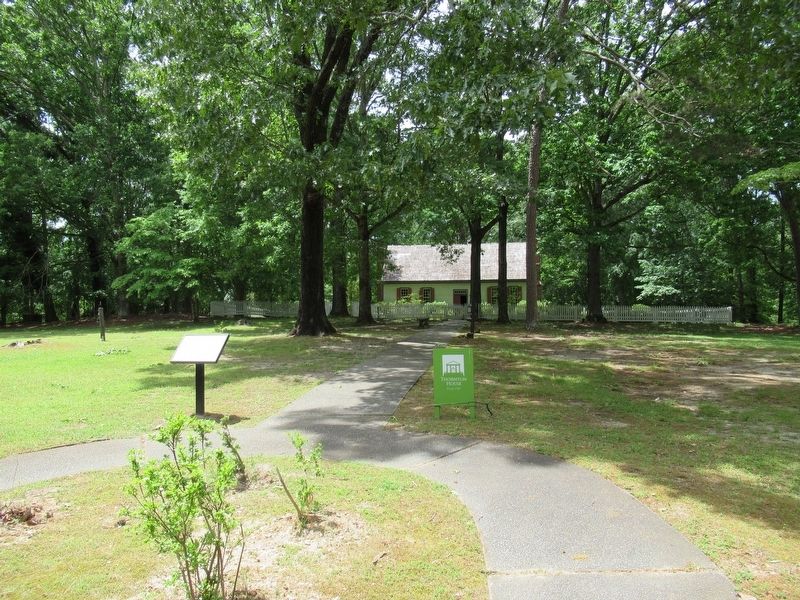
Near John B Gordon Drive 0.1 miles east of Jefferson Davis Drive, on the right when traveling east.
Redmon Thornton and his wife Sarah Alford Thornton built this house in Greene County, Georgia after they moved to the area from Virginia. The house dates to around 1792, when George Washington was president. They had four children together and a . . . — — Map (db m208583) HM
On North Main Street 0 miles north of Court Street, on the right when traveling north.
A native of Greene County, then on Georgia’s Indian frontier, he was educated in the law and admitted to the bar in 1818. The remainder of his exemplary life was spent in the public service as legislator, Captain of Volunteers in the Indian War of . . . — — Map (db m14740) HM
Near Memorial Drive 0.1 miles west of North East Street, on the left when traveling east.
Dr. Rice was born and raised in Prattsville, Alabama. He lived most of his adult life in Greene County and had an abiding love and pride in her past, present, and future. He served her interests in many capacities: pharmacist, county historian, . . . — — Map (db m267649) HM
Near Richland Avenue east of Memorial Drive when traveling east.
Fauche, a Frenchman by birth, was
one of the earliest settlers of
Greene County. He was a military
man and fought in the American
Revolution as a Colonial trooper and
later distinguished himself in the
War of 1812. Immediately after Greene . . . — — Map (db m267713) HM
Near Memorial Drive 0.1 miles west of North East Street, on the left when traveling west.
During the prosperous years before the War Between
the States, many “Georgia” clocks were sold around
the state. These clocks fell into two categories.
In the first category were standardized clocks
purchased directly from Connecticut . . . — — Map (db m267687) HM
Near Memorial Drive west of North East Street, on the left when traveling west.
Peter Early served as Georgia governor from 1813 to 1815, during the War of 1812 with Great Britain and the Creek War of 1813-1814. Born in Virginia in 1773, he graduated from Princeton and moved to Georgia in 1795 to practice law, settling in . . . — — Map (db m267641) HM
Near Memorial Drive west of North East Street, on the left when traveling west.
He was born near Madison, Virginia in 1773, the
son of Joel Early and Lucy Smith. His cousin, Jubal
Early, was the grandfather of Confederate General
Jubal Anderson Early (1816-1894). Peter Early
graduated from the Lexington Academy (current . . . — — Map (db m267646) HM
On Hancock Street at High Street, on the right when traveling north on Hancock Street.
Born Enslaved
December 25, 1803
Greene County, Georgia
Elected in 1868
from Morgan County to the
Georgia House of Representatives
Died December 5, 1878
Madison, Georgia
Additional marker
Georgia House of . . . — — Map (db m264111) HM
Near Georgia Route 15, on the right when traveling north.
American sculptor Abbott Pattison created Iron Horse, also known as, "Pegasus Without Wings", in 1954. The Curtis family rescued Iron Horse from storage in 1959 and relocated it from Athens, Georgia, to a prominent location on their . . . — — Map (db m276042) HM
On North Main Street 0 miles north of Court Street, on the right when traveling north.
In 1874, the Georgia Department of Agriculture was established by Act of the Legislature with Thomas P. Janes serving as its first Commissioner, 1874-79.
Commissioner Janes, born 1823 in present Taliaferro County, (formerly the eastern part of . . . — — Map (db m14726) HM
On North Main Street at East North Street, on the right when traveling north on North Main Street.
This church was organized on September 23, 1863, by the Right Reverend Stephen Elliott, the first Bishop of Georgia. Its original members included two Greensboro families and several women who had migrated inland from Charleston and Savannah to . . . — — Map (db m184198) HM
On North Main Street at Court Street, on the right when traveling north on North Main Street.
Dedicated to the memory of all veterans of Greene County, Georgia who served our country with honor during times of war armed conflict — — Map (db m267611) WM
On County Road 628 south of White Road, on the right when traveling south.
The 5th Arkansas Infantry Regiment was organized on June 28, 1861, at Gainesville about 7 miles northwest of modern-day Paragould. Men from Greene County served in Companies C, D, E and H. The soldiers trained and camped near the springs at Camp . . . — — Map (db m170413) HM
On West Main Street 0.2 miles north of Parks Mill Road, on the left when traveling north.
On the occasion of its Bicentennial, Morgan County placed this marker here to commemorate the community of
Buckhead
One of the earliest settlements in Morgan County, the area around Buckhead was still in close proximity to Native . . . — — Map (db m16136) HM
On Memorial Drive west of North East Street when traveling west.
Affectionately known as “H”, he served as a director on the
Farm Bureau Board and as a Wildlife Ranger for the State
of Georgia where he was instrumental in the beginning of the
Aquaculture Commodities Program for the State.
He was an . . . — — Map (db m267781) HM
Near Briar Lane 0.1 miles west of Ryan Road, on the right when traveling west.
John W. Ray, his wife, Martha; their infant son; and her fifteen-year-old brother, James R. Conyers, moved to Mt. Meigs from Greene County, Georgia. He and his older brother, Isaac Ray, owned extensive landholdings along Vaughn and Taylor Roads. . . . — — Map (db m86473) HM
Near Barley Drive west of Sandtown Road, on the left when traveling west.
Georgia's coast stretches for approximately 100 miles from the Savannah River in the north to the St. Marys River in the south.
Separating the mainland from the Atlantic Ocean is a series of barrier islands. These islands are several miles . . . — — Map (db m301252) HM
On South Main Street (Georgia Route 44) 0 miles north of West South Street, on the right when traveling south.
During the early years of its settlement, Greensborough and Greene County suffered greatly from depredations committed by Indians who occupied the West bank of the Oconee River about eight miles from here. Most tragic of these was the destruction of . . . — — Map (db m38892) HM
Near Richland Avenue east of Memorial Drive, on the left when traveling east.
On April 20, 1865, Gwyn Allison, an old
bachelor, the son of a Revolutionary
soldier and a first cousin of President
Andrew Jackson, realizing that his
end was near, called in his lawyer and
dictated his will.
Fortune had smile on him and . . . — — Map (db m267708) HM
On Parks Mill Road at Reids Ferry Road, on the right when traveling east on Parks Mill Road.
On the occasion of its Bicentennial, Morgan County placed this marker here to commemorate the community of
Park’s Mill
The construction of Park’s Mill is thought to be contemporary with the creation of Morgan County by act of the Georgia . . . — — Map (db m17274) HM
On U.S. 13 (U.S. 258) at County Route 903, on the right when traveling north on U.S. 13.
On July 18, 1863 Union Gen. Edward E. Potter led infantry and cavalry from New Bern to destroy the Wilmington and Weldon Railroad bridge at Rocky Mount. The infantry feinted toward Kinston and retreated to New Bern. Potter raided . . . — — Map (db m222349) HM
On North East Street 0 miles south of East Greene Street, on the left when traveling north.
This 1895 jail is named for the legendary Sheriff, Loy Lee Wyatt, who enforced the laws in Greene County for fifty-two years until his death in 1977. Sheriff L.L. Wyatt was born on January 2, 1904, in Paulding County. He was recruited to serve the . . . — — Map (db m15997) HM
On North Carolina Route 903 0.2 miles east of Edwards Bridge Road (County Route 1004), on the left when traveling east. Reported permanently removed.
(preface) On July 18, 1863, Union Gen. Edward E. Potter led infantry and cavalry from New Bern to destroy the Wilmington and Weldon Railroad bridge at Rocky Mount. The infantry feinted toward Kinston and returned to New Bern. Potter . . . — — Map (db m266003) HM
On Skull Shoals Road 3 miles west of Macedonia Road, on the left when traveling west.
1784 First white settlers arrive
1793 Fort Clark built
1810 Georgia's first paper mill
1845 Fire destroyed mills, rebuilt 1847
1861-65 No damages here in Civil War
1887 Flood covered town, removed bridge
1897 Mills sold, town . . . — — Map (db m197804) HM
Near Capitol Avenue Southwest south of M.L.K. Junior Drive Southeast, on the left when traveling north.
Expelled Because of Color” is dedicated to the memory of the 33 Black state legislators who were elected, yet expelled from the Georgia House because of their color in 1868.
The cinder block forms at the base of the sculpture symbolize the . . . — — Map (db m130191) HM
On Buckeye Road (County Route 29) north of Mason-Dixon Highway (West Virginia Route 7), on the left when traveling north. Reported missing.
Branch of Warrior Trail of the Great Catawba Indian War Path located here where Mason and Dixon Survey crossed Dunkard Creek for third time. Guide, Six Nations Indians’ chief, declared he “would not proceed one step further,” because hostile . . . — — Map (db m175212) HM
Thin black lines indicate changes in relevance. Between each pair of lines entries are ordered geographically but all have the same relevance.
* Inflectional forms of words are their plurals, singulars, and possessives as well as gramatical tenses and similar variations.