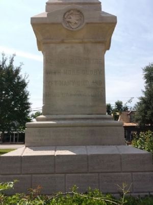
On West Tuskeena Street (Alabama Route 21) at South Commerce Street ( Route 97), on the left when traveling west on West Tuskeena Street. Reported permanently removed.
(front)
1861-1865
The Soldier Dead
of Lowndes
(left side)
No men died there
with more glory.
Yet many died,
And there was much glory.
(right side)
To
Devotion and Valor. . . . — — Map (db m68342) WM
On Lincoln Road 0.1 miles north of Harrison Road, on the right when traveling north.
Born enslaved in North Carolina on July 27, 1847. Hugh A. Carson likely came to Alabama after the Civil War. He married Eliza Stewart (1854-1939) in 1873. The couple had six children.
Near the end of the Reconstruction era, Carson entered the . . . — — Map (db m205228) HM
Since the federal registrars came in August of 1965, thousands and thousands of Negroes have registered to vote. White plantation owners have retaliated by mass evictions. In December 1965, over forty families either left the county, moved in . . . — — Map (db m112405) HM
On North Broad Street 1.1 miles U.S. 80, on the left when traveling north.
Lowndesboro, Alabama
Lowndesboro developed from a small community of early settlers to a thriving township in the 1830’s. The settlers’ plantation interests were maintained in the lowlands along the Alabama River, while they built their . . . — — Map (db m70934) HM
For African Americans in the 1960s, being kicked off white-owned lands for trying to register to vote no isolated incident. Just as had happened here in Lowndes County, blacks in Tennessee, Mississippi, and Greene County, Alabama, were driven from . . . — — Map (db m112389) HM
On West Hickory Grove Road 1.3 miles east of Route 97, on the right when traveling east.
Lynching in America
Thousands of black people were the victims of lynching and racial violence in the United States between 1877 and 1950. The lynching of African Americans during this era was a form of racial terrorism intended to . . . — — Map (db m97983) HM
On Snow Hill Drive at Route 21, on the right when traveling west on Snow Hill Drive.
Enslavement & Racial Terror
The enslavement of black people in the United States was a brutal,
dehumanizing system that lasted more than 200 years. Between 1819
and 1860, Alabama's enslaved population grew from 40,000 to 435,000.
According . . . — — Map (db m154554) HM
On U.S. 221 at Old River Road, on the right when traveling west on U.S. 221.
A short distance East on this road is Fender Cemetery, in which are buried many of the first settlers of the area of old Lowndes County lying East of the Alabama River, from Union Church. This location for the Cemetery was chosen because of the . . . — — Map (db m14669) HM
Near County Road 165 at Hilltop Farm Road, on the left when traveling south.
Established prior to 1833, the Robinson-DeJarnette Cemetery is located
on property first granted by the U. S. Government to early Autauga County
settler James Jackson. In 1825, Jackson transferred the land patent to
Eli Terry Sr. On March 16, . . . — — Map (db m294231) HM
Near Montgomery Street at State Street, on the left when traveling north.
Scores of people lost their lives in the struggle against racial injustice. Here are the portraits of 32 people whose deaths profoundly impacted those who organized, boycotted, and marched in Montgomery, Alabama.
[Left to Right - . . . — — Map (db m304155) HM
Near North G Street at West Belmont Street, on the left when traveling north.
The body of Martha F. Screven was the first to be buried in the cemetery. Over 20,000 interments followed. With proper management, there is ample space to accommodate burials over the next 200 years. — — Map (db m298490) HM
On Magrill Street at N 5th Street on Magrill Street.
Georgia native O.H. Methvin came to Texas about 1848 with his wife Margaret and his father, Richard R. Methvin. They settled on land in Upshur County which would later become a part of Gregg County. In 1870 Methvin gave 100 acres of land to the . . . — — Map (db m290334) HM
On U.S. 80 at Trickum Cutoff Road, on the right when traveling west on U.S. 80.
The roots of this house of worship date to 1868 when 26 African American members of Mount Gilead Church left to form their own congregation. The present building was constructed in 1901, with several enlargements and renovations throughout the . . . — — Map (db m104068) HM
On South Jackson Street at High Street, on the right when traveling south on South Jackson Street.
South Jackson Street
Long a home to African-American professionals, politicians, and businessmen, South Jackson Street is in the heart of Centennial Hill, a neighborhood which developed in the 1870s. One block north at No. 309 is the house . . . — — Map (db m71354) HM
On State Highway 7 at Ebenezer Church Road (County Highway 462), on the right when traveling east on State Highway 7.
Bardin King (1819-1891) and Elizabeth Susan Salter (1822-1879) married in Lowndes County, Alabama in 1842. The following year, they traveled west by wagon with their young son William and Susan’s parents and siblings, settling in Louisiana. Bardin . . . — — Map (db m156969) HM
On North Trinity Street (Farm to Market Road 730) south of East Walnut Street, on the right when traveling south.
Captain George W. Stevens was born in Lowndes County, Alabama, on July 12, 1830. He lived in Arkansas briefly where he married Martha McDonald in 1852. The couple moved to the Wise County area in 1855 and Stevens became a leader in the efforts to . . . — — Map (db m108526) HM
On Lincoln Road 0.1 miles north of Harrison Road, on the right when traveling north.
Side 1
Lincoln Cemetery
1907
In 1907 the American Securities Company opened Lincoln Cemetery for African Americans and Greenwood Cemetery for whites, the first commercial cemeteries in the city. Landscape design indicates . . . — — Map (db m71342) HM
On Pine Street at Knight Street, on the left when traveling south on Pine Street.
The church, founded in 1893, played important
roles in the 1960s’ voting rights struggle in
Lowndes County. The second building constructed
in c. 1959 hosted community meetings and voter
registration activities. The Lowndes County
Freedom . . . — — Map (db m285535) HM
On Howard Lane 0.1 miles South Broad Street (County Road 29), on the left when traveling east.
The Lowndesboro School is among the oldest surviving Reconstruction-era
African American schoolhouses in the United States. It was founded in 1867
by Dr. Mansfield Tyler, an educator, minister, and member of the Alabama
House of . . . — — Map (db m245992) HM
On William Street north of West Broadway Street, on the right when traveling south.
Prisoners at Alton Military Prison
The Alton Military Prison was inhabited by four different classes of prisoner, Confederates, civilians, Federal soldiers and a group called guerillas or bushwhackers.
Confederate prisoners of war made up . . . — — Map (db m211487) HM
On East Lafayette Street at South Washington Street, on the left when traveling east on East Lafayette Street.
Lynching in America
Between the end of the Civil War and the close of World War II,
white mobs killed thousands of Black Americans in racial terror
lynchings, and committed widespread violence that traumatized
millions more. The Lowndes . . . — — Map (db m235867) HM
Threatened by the potential four-to-one advantage of the black vote, whites retaliated by ousting black families from white-owned lands. The African American families who lived here paid dearly to earn their right to vote. Crowded into canvas tents . . . — — Map (db m112400) HM
Monday, March 22, 1965, on the second day of the Selma to Montgomery Voting Rights March, protesters passed this site in late afternoon. At that time the four-lane highway in front of you was only two lanes, and for safety reasons the number of . . . — — Map (db m112375) HM
At times history and fate meet at a single time in a single place to shape a turning point in man's unending search for freedom. So it was at Lexington and Concord. So it was a century ago at Appomattox. So it was last week in Selma, Alabama. . . . — — Map (db m112403) HM
While helicopters buzzed overhead, National Guard soldiers—ordered by President Lyndon Johnson to protect the marchers—lined U.S. Highway 80, alert to the potential of violence by angry whites. Marchers walked mile after tired mile, while black . . . — — Map (db m112384) HM
In December 1965, a city of tents appeared on this site. The temporary shelters were homes for evicted black sharecropper families. These farmers worked and lived their lives on white-owned farms in Lowndes County. But when they dared to register to . . . — — Map (db m112371) HM