On North Union Street north of West Peace Street (State Route 22), on the right when traveling north.
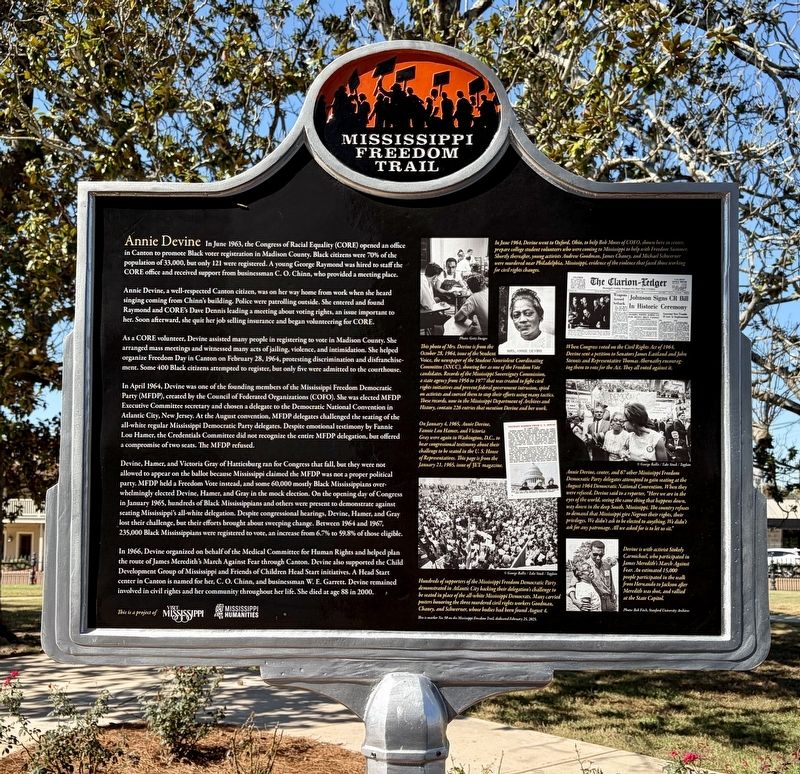
Annie Bell Robinson Devine (1911-2000) was born
in Mobile, Alabama, but lived most of her life in
Canton. She attended Tougaloo College, married,
had four children, and worked as an elementary
school teacher and life insurance agent. A . . . — — Map (db m314861) HM
On U.S. 231 0.2 miles north of State Route 36, on the right when traveling north.
Abundant water and fertile land in this area south of the Tennessee River attracted pioneer settlement in the early 1800s. The community established here by three Virginia-born brothers, Hopkins, John, and Theophilus Lacy, took on their name and . . . — — Map (db m27611) HM
On Main Street, on the right when traveling south.
From Chicago to Los Angeles, Route 66 was routed over the streets of cities and towns both large and small. Thus its nickname "The Main Street of America." In Illinois, the first state to have all of Route 66 paved, the infamous highway was routed . . . — — Map (db m139428) HM
Near Champion Hill Road 0.2 miles west of South Farr Road.
In 1853, the land now known as Champion Hill was given to Sid and Matilda Champion as a wedding present from her father, Eli Montgomery. They erected a two-story white-frame house along the Jackson Road that overlooked the railroad. In 1862, Sid . . . — — Map (db m86780) HM
On Surveyor Road 0.2 miles west of Cloverdale Road, on the left when traveling west.
John Coffee was born in Prince Edward County, VA, in 1772, the son of Joshua and Elizabeth Graves Coffee. The family moved to NC in 1777. After his father died in 1798, Coffee and other family members moved to Davidson County, TN where he . . . — — Map (db m100248) HM WM
On State Highway 43 0.1 miles west of Natchez Trace Parkway, on the left when traveling west.
This monument marks the Natchez Trace over which our pioneer ancestors came to Mississippi. It is located on the site of Madisonville, an early county seat of Madison County.
Erected by the Mississippi Daughters of the American Revolution, . . . — — Map (db m87496) HM
On Ryland Pike west of Dug Hill Road, on the left when traveling west.
In October, 1808, the Western Conference of the Methodist Episcopal Church sent James Gwinn, a circuit rider, to the "great bend" of the Tennessee River to formalize existing Methodist Societies. He organized the Flint Circuit to serve frontier . . . — — Map (db m39767) HM
On U.S. 190 at Oxford Cemetery Road (County Road 429), on the left when traveling east on U.S. 190.
As the primary burial ground for citizens of the Cottonwood community and the family of Garland Walker Ross (1807-1892) and Elizabeth Hodges Ross (1826- 1882), the Oxford Cemetery was in use as early as 1869.
The Ross family came to Texas . . . — — Map (db m245564) HM
Capt. S.J. Ridley
Lieut. Charles E. Hooker
Lieut. P.B. Lancaster
Forney's Division
Engaged Chamption Hill, May 16
Big Black River Bridge, May 17
Defense, May 18 - July 4
Casualties severe, but not fully . . . — — Map (db m109516) HM
On Bunker Hill Road (Illinois Route 159) 0.1 miles East North Street, on the right when traveling north.
During the historical period, the earliest inhabitants of the present-day community of Bunker Hill were the Peoria, Kickapoo, and Winnebago Indians who established an encampment near North Washington and West Morgan Streets. Another Native American . . . — — Map (db m143178) HM
On West Peace Street (Mississippi Route 22) at North Liberty Street, on the right when traveling west on West Peace Street.
Flonzie Brown Wright became involved in the
civil rights movement after moving back to
Madison County in 1962. Focusing on voting rights.
she served as director for the local chapter of
the NAACP. In 1968, she ran for county . . . — — Map (db m312337) HM
On South Highland Avenue (U.S. 45) at East Main Street, on the right when traveling north on South Highland Avenue.
In June 1862 the Union Army established a headquarters in Jackson. The provost marshal's office located at the court house was the recruiting station for the Union Army. In May 1863, during the Civil War, over 100 African American men from Madison . . . — — Map (db m194031) HM
On Stoneway Trail south of Stoneway Circle, on the left when traveling south.
Born in North Carolina in 1774. Elisha Rainbolt moved with his wife and children in 1807 to the area now called Rainbow Mountain a phonetic distortion of the Rainbolt name. The following year, in 1808, Madison County was organized. Rainbolt was one . . . — — Map (db m299888) HM
On Park Drive just south of West Main Street, on the right when traveling south.
In the mid 1800s, roughly a quarter-mile east of where you stand, Madison County residents carved a settlement from farm fields, prairie grass, broken forests, and the National Road.
Here, the National Road was little more than a scraped-earth . . . — — Map (db m144106) HM
On Adams Lane near State Route 467, on the left when traveling south. Reported missing.
As the Civil War moved into the Deep South, many people
fled the shifting war front. Two coinciding events encouraged
Henry Coker to become a refugee: the death of his wife and the
approach of the Union navy, steaming up the Mississippi . . . — — Map (db m109563) HM
On North Bluff Road (Illinois Route 157) north of Route 162, on the left when traveling north.
Samuel Judy (Tschudi), a Swiss immigrant, was the first permanent white settler. He bought a crude log cabin from Ephraim Conner in 1801. He planted an orchard and completed the first brick home (opposite West Main Street) in 1808.
The area . . . — — Map (db m196835) HM
On North Hickory Street at West Center Street, on the right when traveling north on North Hickory Street.
Hickory Street, known locally as "The Hollow," was a hub of social life, commerce, and entertainment for the African American community of central Mississippi for several decades, up through the 1970s. Canton's most famous blues musician, Elmore . . . — — Map (db m97089) HM
Here in the southern extent of Missouri’s historic southeast Lead Belt, Fredericktown was laid out on Saline Creek, 1819, by state legislator Nathaniel Cook. Commissioners T. F. Tong, Joseph Bennett, James Dotson, John Burditt, and Henry Whitener . . . — — Map (db m61715) HM
On South Mill Avenue at West Court Street, on the left when traveling south on South Mill Avenue.
Col. Robert Henry Dyer served during the War of 1812, including the Creek War and as a commander on the left flank under Gen. Andrew Jackson during the Battle of New Orleans on Jan. 8, 1815. The previous night he was injured when his horse fell on . . . — — Map (db m255371) HM
On Monroe Street at Williams Avenue, on the right when traveling south on Monroe Street.
Tom Goodman Thrasher
August 4, 1916
December 19, 1999
-Grew up in Birmingham, Alabama
-Studied Engineering at the University of Alabama in Tuscaloosa
-Married the former Dorothy Wright of Belmont, Mississippi
-Served in the Army in North . . . — — Map (db m85611) HM
On KK Road (County Road 1300N) just west of Ahne Road, on the right when traveling west.
The Beginning
The settlement of Madonnaville was not always called Madonnavile, it was originally known as James Settlement or James Mills, In June of 1804 ,Austin James moved here with his family. For many years the James family was the . . . — — Map (db m179195) HM
On Ramey Drive 0.3 miles south of Collinsville Road, on the right when traveling south.
In 1806, President Thomas Jefferson signed legislation creating America's first federal highway. The National Road would join the bustling cities of the East to the resource-rich wilderness of the West, connecting state capitals, county seats, . . . — — Map (db m144040) HM
On North Liberty Street (U.S. 51) at West Peace Street (State Highway 22), on the left when traveling north on North Liberty Street.
CORE Activists David Dennis, Matheo Suarez, and George Raymond opened a Madison County office in 1963 to register black voters, the majority in white~controlled Canton. Co~directors Raymond and Suarez were joined by Annie Devine and C.O. Chinn . . . — — Map (db m105553) HM
On Old Canton Road at Rice Road, on the left when traveling north on Old Canton Road.
Although Ridgeland was founded well after the Civil War, several actions occurred
in Madison County during the war. In May 1863, Confederate General Joseph E.
Johnston retreated to this area following the battle of Jackson. For the next . . . — — Map (db m259512) HM
On Greenwood Crossing south of Old Agency Road, on the right when traveling south.
Greenwood Plantation, located off of Old Agency Road, was built in 1854
by Colonel William F. Battley, Sr. (1813-1871). Colonel Battley was a wealthy
planter who moved to Madison County from North Carolina to establish a cotton
plantation. . . . — — Map (db m259724) HM
On Old Town Crossing south of West Jackson Street, on the left when traveling south.
In 1896, two Chicago investors named Edward
M. Treakle and Gorton W. Nichols purchased
land from James B. Yellowley, who had moved to
Madison County in 1853 from North Carolina. In
1900, Nichols, R.H. Thompson and W.H. Shergold
formed the . . . — — Map (db m259561) HM
On SE Madison Drive south of West Jackson Street, on the right when traveling south.
Like many communities, Ridgeland's
early growth was due in large part to
the presence of the railroad. Access to
an existing railroad greatly influenced
Edward Treakle and Gorton Nichols of the
Highland Colony Company to develop
the fertile . . . — — Map (db m259544) HM
On Court Square at South Main Street (Business U.S. 67), on the left when traveling east on Court Square.
First lead mine in the Mississippi Valley
opened at Mine La Motte about the year 1700
St. Michael French Village started about 1799
Madison County approved December 14, 1818
Fredericktown laid out 1819
Discovery of copper at Copper . . . — — Map (db m119696) HM
On West 18th Street at Baynard Boulevard on West 18th Street.
African American Medal of Honor Recipients Memorial
The Medal of Honor takes its place in our country as the highest award for military valor. The honor, awarded by the President in the name of Congress, may only be accorded an . . . — — Map (db m173924) HM WM
On West Street (Illinois Route 157) at West Schwarz Street, on the right when traveling east on West Street.
Route 66, the Mother Road, is an American icon that symbolizes romance and freedom of the open road. Born in 1926, Route 66 was one of the first numbered U.S. highways, journeying 2,500 miles from Chicago to Los Angeles. Today, you can still "get . . . — — Map (db m144542) HM
Thin black lines indicate changes in relevance. Between each pair of lines entries are ordered geographically but all have the same relevance.
* Inflectional forms of words are their plurals, singulars, and possessives as well as gramatical tenses and similar variations.