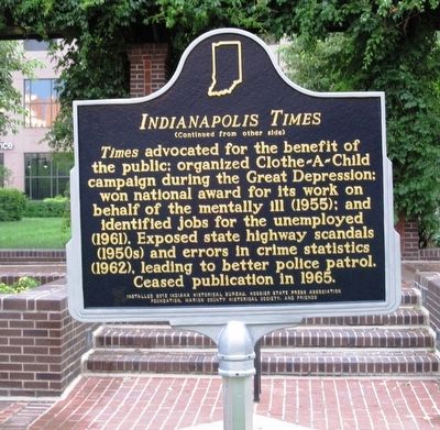
Side 1 The Indianapolis Times (originally published as the Sun in 1888) moved to this site in 1924. In the 1920s, it led a crusade against the Ku Klux Klan, exposing the Klan's influence in Indiana politics and spurring . . . — — Map (db m95234) HM
Authorized by Indiana's 1836 Internal Improvement Act, Central Canal conceived as link in transportation system connecting Wabash and Erie Canal with Ohio River. State's bankruptcy in 1839 prevented completion of Central Canal. Canal has since . . . — — Map (db m95231) HM
On State Road 9 0.5 miles north of County Road 425N, on the left when traveling north. Reported missing.
After the War of 1812, the U.S. renewed efforts to obtain Indian lands in the Indiana Territory. In October 1818, the Miami, Potawatomi, Wea, and Delaware nations under pressure signed treaties with the U.S. exchanging millions of acres of their . . . — — Map (db m277083) HM
1859. Completion of the first building of the Indianapolis City Hospital, forerunner of Marion County General Hospital. Founder of this oldest general hospital in Indiana was Livingston Dunlap, M.D.
1861–1865. The first patients were admitted . . . — — Map (db m265644) HM
On East Michigan Street at East Michigan Street, on the right when traveling south on East Michigan Street.
The Indiana World War Memorial building was modeled after the Mausoleum at Halicarnassus, one of the seven wonders of the world. This known jewel of the Indiana War Memorial Plaza was designed to house the magnificent Hoosier valor and sacrifices . . . — — Map (db m132864) HM
On East Silver Springs Boulevard (State Road 40) at Southeast Magnolia Avenue, on the right when traveling east on East Silver Springs Boulevard.
Designated as a Public Square in the original Ocala plat of 1846, this location was the site of Marion County’s first permanent courthouse built in 1851. It was a two-story frame building of Colonial design. The second courthouse was erected on this . . . — — Map (db m90553) HM
On Old National Road (U.S. 40) at North Layman Ave., on the right when traveling west on Old National Road.
Side A National Road in Marion County
Workers built the National Road through this area in the 1830s, nearly four decades before Irvington’s founding.
A constant stream of travelers on the road drew business to the area. The first commercial . . . — — Map (db m174717) HM
On East South Street at North New Jersey Street, on the right when traveling east on East South Street.
Food is a foundational element of human culture, and Hoosiers have long sought to purchase food from the people who actually produce it. In the 1920s, the Indianapolis Growers Cooperative Association established their own producers market in . . . — — Map (db m303436) HM
Near TVA Road 2.4 miles south of Interstate 24, on the left when traveling south.
Samuel Love owned a farm on the Tennessee River between Jasper and Shellmound. He operated a ferry that was an important transportation artery, linking Jasper and the rest of Marion County with the railroad at Shellmound. In addition to running . . . — — Map (db m87942) HM
Near North Michigan Road north of 38th Street, on the right when traveling north.
In memory of five pioneer families originally buried in southeastern Wayne Township in
Marion County Indiana.
In 1999, twelve adults and thirty-four children of the Rhoads, Rude, Foster, Foltz, and Johns families were buried at this final . . . — — Map (db m239095) HM
On Alabama Street just north of East North Street, on the right when traveling north.
Social reformer Roberta West Nicholson moved to Indianapolis ca. 1925. She co-founded the Indiana Birth Control League in 1932, renamed Planned Parenthood. As state representative, Nicholson sponsored a 1935 “Heart Balm Bill” that outlawed suing . . . — — Map (db m210951) HM
On South Poplar Street (U.S. 51) at County Route 2400N, on the right when traveling north on South Poplar Street.
At the point where U.S. Highway 51 and the Jefferson-Marion County road meet, the Third Principal Meridian intersects its east-west base line. This cardinal point was established by a Federal surveyor on February 1, 1815. At least 60 percent of the . . . — — Map (db m167467) HM
On Bluff Road at W. Hanna Avenue, on the right when traveling north on Bluff Road.
(Front Side)
Many of Indiana's German immigrants settled in southwestern Marion County during the mid-1800s and began greenhouses and truck gardens on Bluff Road; area grew to major boundaries of Harding, Raymond, Madison, and Banta . . . — — Map (db m67188) HM
On U.S. 20 at State Road 49, on the right when traveling east on U.S. 20.
Composed of infantry regiments from Indiana, Wisconsin, and Michigan, the Iron Brigade fought with Army of the Potomac during the Civil War (1861–1865). Received name for valor at battle of South Mountain, Maryland (1862). Sustained combat . . . — — Map (db m202747) HM
On Lake Hills Lane west of Memorial Lane, on the right when traveling west.
The Zachariah O'Neal House is a rectangular single-pen log structure having corner timbering, and constructed with hewn logs. At one end there is a brick chimney. There is some weathering on the north end of the structure, but there is a new roof . . . — — Map (db m167698) HM
On East Main Street at Justice Center Drive, on the right when traveling east on East Main Street.
Christmas Raid
December 31, 1862
Robert Colvin's Warehouse
Postmaster Robert Colvin owned the tobacco warehouse, which also housed the post office, that once stood here. During the Civil War, the U.S. Government leased the . . . — — Map (db m99293) HM
On State Highway JJ 0.6 miles south of State Highway Z, on the right when traveling north.
The July 28, 1862, Battle of Moore's Mill opened about one-eighth mile south along the Moore's Mill-Galbreath Mill road, near today's State Road JJ. This area then was heavily timbered.
Lying in ambush east of the road were about 260 . . . — — Map (db m207957) HM
On North Main Street (Business U.S. 65) at West Rush Avenue, on the right when traveling south on North Main Street.
In memory of those who were killed in the Mountain Meadows Massacre, in September of 1857. Dedicated in 2020.
Modern historical research has yielded information which was not readily available to those who designed the 1955 monument. . . . — — Map (db m225251) HM