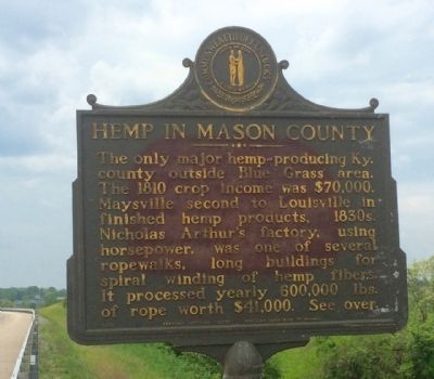
On Business Route 68 0.2 miles east of Clarks Run Road, on the left when traveling east.
Hemp in Kentucky
First crop grown, 1775. From 1840 to 1860, Ky. production largest in U.S. Peak in 1850 was 40,000 tons, with value of $5,000,000. Scores of factories made twine, rope, gunny sacks, bags for cotton picking and marketing. . . . — — Map (db m83598) HM
On Sutton Street at West 3rd Street (Kentucky Route 8), on the right when traveling south on Sutton Street.
Lewis Collins, 1797-1870, born near Bryan's Station, author of Collins' HISTORICAL SKETCHES OF KENTUCKY. He was presiding judge of Mason County, publisher-editor of the EAGLE, lived here 52 years. His 1847 study of his own state-revised by Richard . . . — — Map (db m83621) HM
On Main Street at 1st Street, on the right when traveling west on Main Street.
Here in 1839, with the "Platte Purchase", some of many settlers from Kentucky joined to establish Platte City; one, an Attorney, Merchant, Farmer, Mill Operator, Abstractor, Banker, Public Administrator, Genealogist, Historian, Poet and Civic . . . — — Map (db m63521) HM
Born on September 15, 1839 in Mason County, Kentucky on the plantation of Benjamin Gratz, Lawson Gratz worked as a farmer for his owner prior to the Civil War. Lawson was directed by his owner to enlist in the Federal army on July 24, 1864 at . . . — — Map (db m189460) HM
On Old Main Street north of C Street, on the right when traveling north.
West of the Allegheny Mountains. Originally located at the northern end of Main Street; first postal station in Kentucky, before it was formed as a state from Virginia, was located in Mason County. It was a distribution point for the Northwest . . . — — Map (db m217906) HM
Near Jackson Street south of Seventh Street, on the right when traveling south.
Born in 1808 in Mason County, Kentucky, Beatty and his first wife, Charlotte Reid, moved to Lafourche Parish early in life. He initially practiced medicine but became an attorney and politician, was one of the first Trustees of Thibodaux, and . . . — — Map (db m112646) HM
On Fort McKavitt Street (U.S. 87) 0.2 miles south of Koocksville Rd / W. Spring St, on the left when traveling south.
A native of Kentucky, Thomas S. Milligan (1810-1860) moved to this area in 1855 and operated a change station for the stage line. He was also a rancher and supplied beef to the soldiers at Fort Mason. Shortly after Mason County was organized in 1858 . . . — — Map (db m90949) HM
On Fort Street at 8th Street, on the right when traveling south on Fort Street.
George Bardsley resided on this site from 1869 to 1879. An early-day saloonkeeper, restauranteur and County Commissioner, Bardsley was elected Ellis County Sheriff in 1875 in a bitter contest with Jack Bridges. Bardsley captured Isaac “Big Ike” . . . — — Map (db m204749) HM
Near East 8th Street 0.2 miles east of Cemetery Street, on the right when traveling east.
Set aside a family burial lot on the high ground at a bend in Little Three Mile Creek on his farm in the Fox Military Survey No. 401 Sprigg Township, Adams County, Ohio about 1847. ————The remains of those buried there and not removed to . . . — — Map (db m303660) HM
On Mary Ingles Highway (Kentucky Route 8) west of Market Street / Dover-Minerva Road (Route 1235), on the right when traveling west.
On the Ohio River shore near here
one of the last duels fought in
Kentucky under the “code duello”
took place on May 8, 1862 between
William T. Castro, former Maysville
mayor, and Col. Leonidas Metcalfe,
U. S. Army, Son of former . . . — — Map (db m136295) HM
On Main Street (Ohio Route 93), on the left when traveling east.
Scioto Salt Licks. The Scioto Salts Licks, located in and around Jackson, is an area where naturally occurring salt water, known as brine, flowed to the surface as a salt-water spring. It is known that the spring existed since the Pleistocene . . . — — Map (db m24767) HM
On Old Shelbyville Road at Middletown Square, on the left when traveling west on Old Shelbyville Road.
Joseph Abell built this “Main House” on his 600 -acre plantation about 1803. In 1846, he died at the age of 94. Legend holds that his ghost still guards treasure buried on the plantation. Famed Louisville surgeon Irwin Abell is a descendent of . . . — — Map (db m203150) HM
On Parker Lane at Raymond Road (Kentucky Route 324), on the left when traveling north on Parker Lane.
Placed on the
National Register
of Historic Places
by the United States
Department of the Interior
The school is the only surviving Rosenwald school of its type in northern Kentucky and was the first consolidated Negro school for Mason . . . — — Map (db m218020) HM
On Charleston Road (West Virginia Route 62) 0.3 miles north of the Kanawha River bridge south of Buffalo (Route 869), on the left when traveling north.
Indian Village. The Buffalo Indian Village and Cemetery, between the road and the Kanawha River, was one of the largest Indian towns in West Virginia. It was occupied about 1650 by Shawnee Indians who later moved westward. . . . — — Map (db m137328) HM
On West 3rd Street 0.1 miles west of Market Street, on the right when traveling west.
In Honor of
Stanley Forman Reed
Associate Justice
of the Supreme Court
of the United States
Solicitor General of the United States
General Counsel
Reconstruction Finance Corporation
General Counsel Federal Farm Board . . . — — Map (db m83676) HM
On College Street north of Main Street (State Highway 10), on the right when traveling north.
Erected by the State of Missouri
in honor of
Colonel Alexander W. Doniphan
Commander of First Regiment Missouri
Mounted Volunteers in the War with Mexico
Born Mason County, Kentucky, July 9, 1808
Died Richmond, Missouri, August 8, . . . — — Map (db m157143) HM
Near Winfield Road (West Virginia Route 817) north of Ventroux Road, on the right when traveling north. Reported unreadable.
The 1861 Kanawha Valley Campaign
Union and Confederate leaders both wanted control of the Kanawha Valley, an approach to the Confederate capital at Richmond, Virginia, filled with such important resources as salt and soldiers, whose loyalty . . . — — Map (db m268902) HM
Thin black lines indicate changes in relevance. Between each pair of lines entries are ordered geographically but all have the same relevance.
* Inflectional forms of words are their plurals, singulars, and possessives as well as gramatical tenses and similar variations.