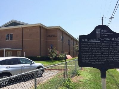
On Virginia Street at Wilkinson Street, on the right when traveling west on Virginia Street.
Council Traditional School was founded and opened in 1910. It is named in honor of William Hooper Councill, a former slave who was the founder of Alabama A&M University in Huntsville, Alabama. This building was erected in 1910 and underwent . . . — — Map (db m86575) HM
A postal worker, a community leader, a state legislator, a journalist, and a civil rights activist, Mobile native John L. LeFlore spent 50 years working to peacefully transform the character of the city and create opportunities to enhance citizens' . . . — — Map (db m111413) HM
On Conception Street Road 0.4 miles south of New Bay Bridge Road, on the right when traveling north.
In 1860, 110 West Africans endured a harrowing Atlantic journey to Mobile Bay aboard the Clotilda, the last US ship to transport enslaved Africans.
As many as seven died at sea. The voyage was orchestrated by Timothy Meaher, who . . . — — Map (db m269504) HM
On Palmetto Street east of South Bayou Street, on the right when traveling east.
On this site stood Emerson Institute, Mobile's first school for the formal education of African-Americans and one of the few 19th-century normal schools for African-Americans in Alabama. Founded 1865 by the Freedmen's Bureau, the school was run by . . . — — Map (db m111289) HM
“Damn The Torpedoes!” is the familiar battle cry, but there’s much more to the story! The Mobile Bay Civil War Trail is your guide to military movements and the way of life on and around Mobile Bay in the closing two years of the Civil War. Stand . . . — — Map (db m81853) HM
On Fort Morgan Road (Alabama Route 180) 1.2 miles west of Dune Road, on the right when traveling west.
(preface)
"Damn the Torpedoes!" is a familiar battle cry, but there's more to the story! The Mobile Civil War Trail is your guide to military movements and the way of life on and around Mobile Bay in the closing two years of the Civil . . . — — Map (db m87247) HM
On South Royal Street south of Government Street, on the left when traveling south.
"Damn the Torpedoes!" is a familiar battle cry, but there's more to the story! The Mobile Civil War Trail is your guide to military movements and the way of life on and around Mobile Bay in the closing two years of the Civil War. . . . — — Map (db m87288) HM
New Hope Gardens, also known as Wheelerville Cemetery is located in an unincorporated area of Mobile County known as Wheelerville and named for Simeon Wheeler, an early settler of the area from South Carolina buried here in 1874. The first known . . . — — Map (db m226737) HM
On Red Fox Road 3.2 miles west of U.S. 43, on the right when traveling west.
Aiokpanchi, "Welcome,” to the Official Tribal Reservation
of the MOWA Band of Choctaw Indians. Chata hapia hoke!
"We are Choctaw.” We are glad you are able to visit us and
hope your visit to our Tribal Reservation is both rejuvenating
and . . . — — Map (db m149288) HM
Near Government Street (U.S. 90) just east of South Cedar Street, on the left when traveling east.
The first public school in Alabama built in 1835-36, used continuously since that time for the purpose of education except for a brief period during the Civil War when it was a hospital. Named for State Rep. Willoughby Barton of Mobile who was the . . . — — Map (db m143517) HM
On Martin Luther King Jr. Avenue at Patton Avenue, on the right when traveling east on Martin Luther King Jr. Avenue.
Vernon Crawford established the first African-American law firm in Mobile. He successfully argued the Birdie Mae Davis case that desegregated Mobile schools. He stood before the Supreme Court and won the landmark case of Bolden vs. the City of . . . — — Map (db m111319) HM
On Franklin Street north of Washington Avenue, on the right when traveling north.
This foundation is all that remains of Baldwin County’s first courthouse.
Authorized in 1820 but not constructed until circa 1833, the two-story brick building contained a jail on the bottom floor with office space on the upper floor. . . . — — Map (db m131830) HM
On Church Street near South Royal Street, on the right when traveling west.
Lynching in America
Racial terror lynching claimed the lives of at least 6,500 Black people in the United States between 1865 and 1859. After the Civil War, many white people remained committed to white supremacy and used lethal violence . . . — — Map (db m202593) HM
On N Rebel Road at N Bessemer Ct, on the left when traveling north on N Rebel Road.
Lynching in America
Between 1865 and 1950, over 6,500 Black people were victims of racial terror lynching across the United States. After Emancipation, many white Southerners remained committed to an ideology of racial hierarchy and used . . . — — Map (db m300493) HM
Near West Turner Road north of N Wasson Ave, on the left when traveling north.
Lynching in America
Between 1865 and 1950, over 6,500 Black people were victims of racial terror lynching across the United States. Almost 25% of lynchings involved allegations of inappropriate behavior between a Black man and a white . . . — — Map (db m300509) HM
Near Old Shell Road (County Road 70) east of Cosgrove Drive, on the right when traveling east.
The earliest known graves are those of John
and Elizabeth Miller, the children of Francis
William Miller who emigrated from Sweden and
Jane Thompson who emigrated from Ireland.
Miller family descendants settled the area
between Spring Hill and . . . — — Map (db m226740) HM
On Moffett Road (U.S. 98) 0.6 miles south of Snow Road North, on the right when traveling south.
Owen and Vivian Welch Blackwell founded Blackwell Nurseries, Inc.
in 1938, and by the late 1960s the nursery became known as the
largest azalea producer in the nation which helped earn the
reputation of Semmes as the "Nursery Capital of the . . . — — Map (db m226738) HM
On Dales Ferry Road (County Road 1) at U.S. 84, on the right when traveling west on Dales Ferry Road.
On April 6, 1825, General Lafayette, descending the Alabama River, was honored in Claiborne where he was addressed by James Dellet. — — Map (db m239945) HM
On State Highway 210 0.3 miles east of County Highway 5, on the right when traveling east.
Flight From Religious Persecution Led to the Organization of Otter Tail County's First Permanent Settlement.
The Cutlerites
Clitherall was settled by the Cutlerites, a branch of the Church of Latter Day Saints on May 6, . . . — — Map (db m260485) HM
Thin black lines indicate changes in relevance. Between each pair of lines entries are ordered geographically but all have the same relevance.
* Inflectional forms of words are their plurals, singulars, and possessives as well as gramatical tenses and similar variations.