Near London Ranch Road 1 mile west of Arnold Drive.
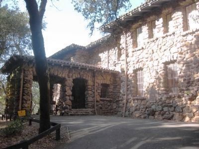
This is the "House of Happy Walls", built by Charmian K. London in 1919 in memory of her husband, Jack London, renowned author. Here are housed many of his works and the collection gathered in their travels throughout the world. Charmian's house, . . . — — Map (db m24996) HM
On Doran Beach Road west of California Route 1, on the left when traveling west.
Discovered in 1602-03 by the expedition of Vizcaíno. It was named by Bodega in his survey of 1775. The harbor was used in 1790 by Colnett and by the Kusov expeditions in 1809 and 1811. The Russian-American company and their Aleut hunters used the . . . — — Map (db m856) HM
On Bodega Highway, on the right when traveling east.
Built in 1856 Watson District School is an example of one-room schools in Sonoma County. This is the original site and the school remains in its original condition. It served as a public school for 111 years, longer than any other one-room school in . . . — — Map (db m81126) HM
Near Franklin Avenue, on the right when traveling north.
Civil War veteran, newspaper editor, banker, and land speculator, James Armstrong arrived in Santa Rosa in 1874. Beginning in 1892, he strove to
preserve 400 acres of redwoods north of Guerneville. After his death in 1900, his daughter Elizabeth . . . — — Map (db m316515) HM
Near Upper Hoh Road 0.1 miles east of Linder Creek Lane, on the left when traveling east.
In the early 19th century what is today the northwest coast of Washington State might have become a Russian colony, an extension of Alaska, if the Sv. Nikolai voyage had been successful. This could have led to this section of New Albion, the . . . — — Map (db m129579) HM
A STUMP IS ALL THAT REMAINS of a Silver Maple transplanted from the Battlefield of Chattanooga. In 1897 the sapling was planted here as part of a Memorial Grove dedicated to Union soldiers who fought in the Civil War. The first war memorial to . . . — — Map (db m14984) HM
On North Cloverdale Boulevard near West 2nd Street, on the left when traveling north. Reported missing.
The "Cloverdale Reveille" is the oldest weekly newspaper continuously published under the same name in the state of California. Founded in the 1870s, and surviving the ups and downs of frontier journalism, the "Cloverdale Reveille" was adjudicated . . . — — Map (db m102479) HM
[Front of Marker:]
DONNER
Here lies George Donner, Jr., a California Pioneer and a Donner Party survivor. He was born 10 August 1836 in Sangamon County, Illinois, the eldest son of Jacob Donner and Elizabeth Blue Hook. In April 1846 . . . — — Map (db m30305) HM
Luther Burbank was born in Massachusetts on March 7, 1849 and arrived in Santa Rosa in October 1875. In 1884 he purchased four acres surrounding this site as a place for horticultural experiments. Here he lived and worked until his death on April . . . — — Map (db m12590) HM
Near Santa Rosa Avenue near Charles Street, on the right when traveling north.
In This Garden 1881 - 1926 Luther Burbank wrought with living plants to bring the world greater fertility, wealth and beauty developing new varieties which produced better fruits and more beautiful flowers. — — Map (db m159543) HM
On McDonald Avenue east of McDonald Place, on the right when traveling west.
The McDonald Mansion, originally called "Mableton", was built in 1879 as a summer home for the McDonald Family, whose primary residence was in San Francisco. The family chose the name "Mableton" in homage to the Mississippi family home of . . . — — Map (db m270223) HM
On El Camino Real at Main Street, on the right when traveling north on El Camino Real.
Born in Philadelphia in 1826, Columbus Tustin was the City's founder
and namesake. He met his wife Mary in Sonoma County, California
and moved to Southern California with their children. He worked as a
carriage maker, miner, farmer, postmaster, . . . — — Map (db m148653) HM
Near East Callahan Road (County Route 3), on the left when traveling south.
Born March 6, 1835 in Lexington, Missouri, Tacitus, at the age of nineteen, left for California by the southern overland route. The journey took six months to complete. He spent many years mining in Napa and Sonoma Counties, working on a ranch in . . . — — Map (db m70296) HM
On Petaluma Avenue (California Route 116) near Burnett Street, on the left when traveling north.
Hogan Building
Petaluma & Santa Rosa R.R.
has been placed on the
National Register
of Historic Places
by the United States
Department of the Interior
1903 — — Map (db m85927) HM
The first Valencia Orchard in California was planted here in 1880 by R.H. Gilman on the property of Placentia Fruit Co. The trees are still in flourishing condition.
Dedicated by Grace Parlor No. 242
Native Daughters of the Golden West . . . — — Map (db m254135) HM
Fred Wiseman's plane is on display
in the Smithsonion Museum in
Washington D.C. It was the first
California built airplane and flew the worlds
first airmail.
A bicycle mechanic and aviation pioneer, Fred Wiseman and his . . . — — Map (db m153716) HM
Near Shoreline Highway (State Highway 1) south of Dillon Beach Road, on the right when traveling south.
Warren Dutton, (1823-1903) co-founder of Tomales, came here from the gold fields in 1852, staked a claim to what is now known as Upper Town, and became partners with John Keys. Within a few years the relationship deteriorated, but the bitter . . . — — Map (db m54784) HM
Near Old Winery Road east of Lovall Valley Road, on the left when traveling east.
Across this creek, and extending for several miles were the vineyards and home of our Count. In 1857 he had acquired 750 acres from Julius K. Rose, a San Francisco real estate investor for $11,500. The property was wedged between two flanks of the . . . — — Map (db m231504) HM
On Paradise Drive, on the right when traveling south.
In 1869, the San Francisco & North Pacific Railroad was founded by Peter
Donahue, a San Francisco industrialist. The southern terminus, Donahue's Landing, was
near Lakeville on Petaluma Creek in Sonoma County.
In 1884, Donahue extended . . . — — Map (db m316123) HM
On Coast Highway (California Route 1) 0.7 miles north of Halcyon, on the right when traveling south.
Sakha on the Sonoma Coast in the 1800's:
Historical records show that at least 16 Sakha people lived at Fort Ross (1812-1842). Serving Russian fur traders as guides across their Siberian homeland, the Sakha were pressed into service in . . . — — Map (db m198880) HM
On Plymouth-Shenandoah Road, on the right when traveling north.
D’Agostini Winery was started in 1856 by Adam Uhlinger, a Swiss immigrant. The original wine cellar, with walls made from rock quarried from nearby hills, hand hewn beams, and oak casks, is still in use and part of the present winery. Some . . . — — Map (db m300991) HM
Thin black lines indicate changes in relevance. Between each pair of lines entries are ordered geographically but all have the same relevance.
* Inflectional forms of words are their plurals, singulars, and possessives as well as gramatical tenses and similar variations.