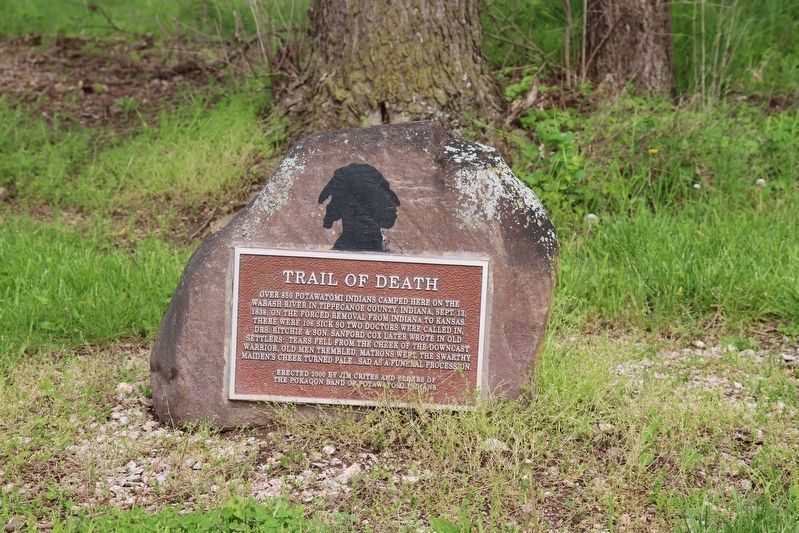
On County Road S 950 W south of County Road W 75 S, on the right when traveling south.
Over 850 Potawatomi Indians camped here on the Wabash River in Tippecanoe County, Indiana, Sept. 13, 1838, on the forced removal from Indiana to Kansas. There were 106 sick so two doctors were called in, Drs. Ritchie & son. Sanford Cox later wrote . . . — — Map (db m33811) HM
On North 12th Street at Howell Street, on the right when traveling south on North 12th Street.
Commander of the 10th Indiana Infantry and highest ranked Tippecanoe County officer killed during the Civil War. He died on September 19, 1863 at the Battle of Chickamauga in Tennessee. Colonel Carroll was one of 34,624 casualties of that . . . — — Map (db m314752) HM
On U.S. 52 0.4 miles north of East 700 South, on the right when traveling south.
Site of First Successful Caesarean Section In Indiana- On the kitchen table of this house, the morning of November 6, 1880, Mrs. Luther Lucas, a farmer’s wife, was delivered of a healthy infant son, after a mid-line incision made by Dr. Moses Baker, . . . — — Map (db m170762) HM
On Battleground Avenue at North 9th Street, on the right when traveling north on Battleground Avenue.
Designates 1838 Potawatomi "Trail of Death" route starting in Indiana, crossing Illinois and Missouri, and ending at present day Osawatomie, Kansas.
In September 1838 over 850 Potawatomi Indian people were rounded up and marched at gunpoint . . . — — Map (db m314697) HM
[Map] Designates 1838 'Trail of Death' route from Indiana to present day Osawatomie, Kans.
In September 1838 over 850 Potawatomi Indian people were rounded up and marched at gunpoint from their Indiana homeland. Many walked the 600-mile . . . — — Map (db m70654) HM
Near South River Road, on the left when traveling west.
This "Liberty Tree" has been planted in honor of those Patriots laid to rest in Tippecanoe County and the State of Indiana whose service and sacrifices helped form this nation during its War for Independence — — Map (db m245689) WM
On County Road W 75 S east of Voyager Way, on the left when traveling east.
Granville cemetery was once part of the great Wea Plains and still contains many species of the original prairie vegetation. This is one of the last remnants of the Indiana prairies that covered much of Tippecanoe County. It is preserved and managed . . . — — Map (db m34903) HM
On Prophet Street at Railroad Street, on the right when traveling south on Prophet Street.
This site is not the original plotting of the pioneer cemetery. It appears the headstones were removed from their original plots sometime around 1875 when the Methodist Church developed the grounds as a campground. Some of the larger headstones such . . . — — Map (db m314702) HM
On Indiana Route 225 at Pretty Prairie Road, on the right when traveling south on Indiana Route 225.
The Prophet’s Town
In the spring of 1808, Shawnee brothers, Tecumseh (left) and The Prophet (Tenskwatawa) established Prophetstown, the capital of a Native American confederacy. The village was located on the north bank of the Wabash River, . . . — — Map (db m314732) HM
On Main Street west of North 4th Street, on the left when traveling west.
The Tippecanoe County Courthouse
Neoclassic Architecture
on the
National Register of Historic Places
Construction Started 1881
Completed 1884 — — Map (db m34764) HM
On Happy Hollow Road at Catherwood Drive, on the right when traveling south on Happy Hollow Road.
Welcome to the West Lafayette segment of the Wabash Heritage Trail. Near the southern end, the West Lafayette segment connects to the Tippecanoe County portion of the Wabash Heritage Trail, a hiking- only section leading to Fort Ouiatenon. At . . . — — Map (db m314662) HM
On South Sixth Street at South Street on South Sixth Street.
Collection of
Donald Jay Stein
Lafayette, Indiana
To the City of Lafayette/West Lafayette and more specifically, to the people of "the South Side" with whom I have worked diligently over the past . . . — — Map (db m284760) HM
On Prophet Street at Railroad Street, on the right when traveling south on Prophet Street.
In 1857 Bishop E.R. Ames & Elder Benjamin Winans of the Methodist Episcopal Church helped to establish the Battle Ground Collegiate Institute. The history of the school is sketchy, but most researchers feel the school ceased to exist in 1875. . . . — — Map (db m314701) HM
On Highland Avenue south of Kossuth Street, on the right when traveling south.
Highland Park Neighborhood
Has Been Placed on the
National Register
of Historic Places
by The United States
Department of the Interior
Listed March 14, 1996 — — Map (db m34914) HM
Thin black lines indicate changes in relevance. Between each pair of lines entries are ordered geographically but all have the same relevance.
* Inflectional forms of words are their plurals, singulars, and possessives as well as gramatical tenses and similar variations.