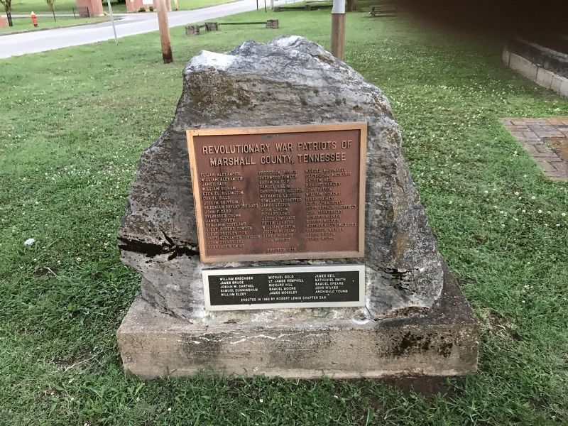
On Yell Road at Ralph Whitesell Drive, on the right when traveling south on Yell Road.
Elijah Alexander • William Alexander • James Bass • William Bigham • Ezekiel Billington • Daniel Bills • Joseph Brittain • Hezekiah Bryant (Briant) • John F. Carr • Sylvester Chunn • James Coffey • Benjamin Copeland • Lieut. Robert Cowden • Lieut. . . . — — Map (db m152140) WM
On Shelbyville Highway (Tennessee Route 64) 0.2 miles west of David Road, on the right when traveling west.
The Farmington engagement took place along this road during Confederate Gen. Joseph Wheeler's October 1-6, 1864, raid through the Sequatchie Valley to cut supply lines to Federal-occupied Chattanooga. Wheeler and his 4,000 cavalrymen captured or . . . — — Map (db m151054) HM
On Blount Avenue 0.1 miles north of Taylor Street, on the right when traveling north.
Montgomery Gilbreath had this board-and-batten house constructed prior to the beginning of the Civil War. Its design is probably based on one of the published house plans of famed landscape gardener and architect A.J. Downing (1815-1852) of . . . — — Map (db m235551) HM
On South Main Street at Cullman Road (Alabama Route 69), on the right when traveling south on South Main Street.
Indirectly responsible for the naming of the town, Stephen Tuttle Thompson was born Feb. 22, 1832, in Rhea County, Tennessee. He moved to west Marshall County with his parents about 1840 and relocated in 1858 to what became Thompson’s Village and . . . — — Map (db m85852) HM
On Lurleen B Wallace Drive (Alabama Route 79), on the right when traveling south.
January 15, 1865 was perhaps the darkest day in the history of Guntersville. At noon, forty Federal marines from the gunboat U.S.S. General Grant were sent to burn the town. After the mission was completed, only seven buildings remained standing – . . . — — Map (db m227313) HM
On South Memphis Street at East Van Dorn Avenue, on the left when traveling south on South Memphis Street.
Grant's long and vulnerable railroad supply line to Holly Springs originated in Columbus, Kentucky, and ran outh along the Mobile & Ohio and Mississippi Central railroads. On December 19, 1862, Brigadier General Nathan B. Forrest's Confederate . . . — — Map (db m183931) HM
On Pyles Road 0.1 miles south of Dean Road, on the left when traveling south.
The Nathan Bedford Forrest Boyhood Home, the only surviving house of three that the Forrest family occupied in the northern end of Marshall County, is located a quarter mile ahead of you. In 1830, Forrest's father, William Forrest, bought the . . . — — Map (db m196648) HM
On Lewisburg Highway (Alternate U.S. 31) just north of Interstate 65, on the left when traveling north.
Giles County
Established 1809: named in honor of Senator William B. Giles of Virginia. One of the strongest advocates for the admission of Tennessee to the Union; he served in U.S. Senate from 1804 to 1815 and was Governor of Virginia, 1827-30. . . . — — Map (db m146816) HM
On West Church Street at North 1st Avenue, on the left when traveling west on West Church Street.
After the attack on Fort Sumter in April 1861, when the Civil War began, a large majority of Marshall County residents supported the Confederacy. They gathered on the Courthouse Square for war news and information about how and where to enlist. At . . . — — Map (db m151086) HM
On Main Avenue S (U.S. 431) at College Street (U.S. 64) when traveling south on Main Avenue S.
In November 1809, thirteen years after
Tennessee became a state, settlers of
lower Bedford County saw the need to
establish a new county which resulted
in an act being passed by the General
Assembly in Knoxville that a county,
to be called . . . — — Map (db m191646) HM
On Nashville Highway at N Park Road, on the left when traveling south on Nashville Highway.
It is thought that the Duck River had more mills on it than any other river in Tennessee. Drawings by local river historian Joe Brooks show examples of the number of mills on the Duck River and its tributaries around the Shelbyville and Chapel . . . — — Map (db m297576) HM
Near Dexter Avenue east of Decatur Street, on the right when traveling east.
Great Depression
The U.S. economy collapsed in late 1929, triggering a
national crisis. Alabama's rural residents had weathered
hardship for decades. Now urban workers and professionals
also faced economic ruin. Businesses closed, factories . . . — — Map (db m182629) HM