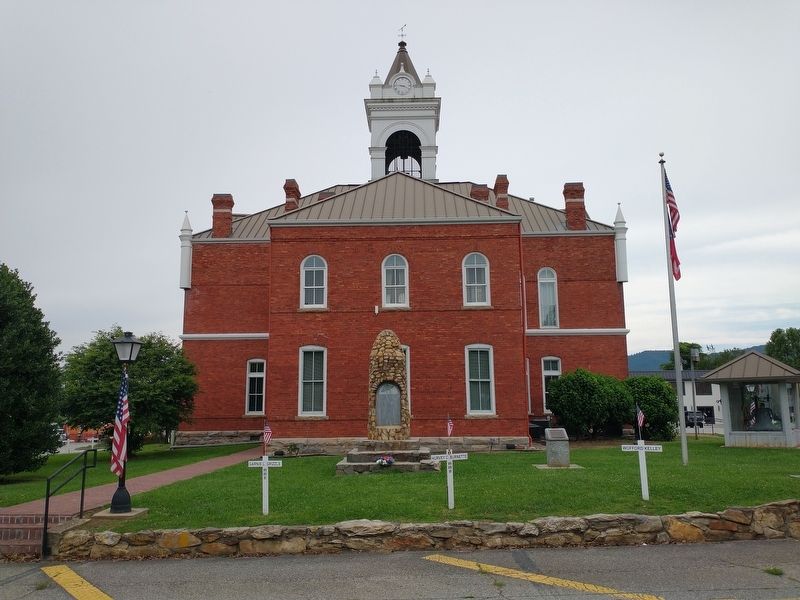
On Town Square near Cleveland Street, on the left when traveling east.
In memory of those who made the ultimate sacrifice in the service of their country
World War I
Akins, Claude • Brackett, Luther • Butt, Claude • Christopher, Ervin • Holbrooks, Nathaniel • Spiva, Cornelius • Stephens, Fred • Weaver, Ira . . . — — Map (db m230151) WM
On Young Harris Highway (U.S. 76) at Trackrock Gap Road, on the right when traveling east on Young Harris Highway. Reported missing.
The road leading south crosses Trackrock Gap, two miles from here. Soapstone boulders in the gap are covered with tracks, symbols, and patterns carved in the rocks by primitive man. The gap was called by the Cherokee Datsu nalasgun'yi, "where there . . . — — Map (db m14150) HM
On East Marietta Street 0 miles north of Elizabeth Street, on the right when traveling north.
Born April 15, 1821 in Pickens District, South Carolina, he grew up in Union County, Georgia. He taught to pay for his education and while teaching in Canton he read law at night, being admitted to the bar in August, 1845. He graduated from the . . . — — Map (db m21891) HM
On Georgia Route 60 0.1 miles north of Hello Road.
Joseph Emerson Brown (1821-1894), born in Pickens District, South Carolina, moved to Union County, Georgia, as a boy. The old Brown home was on the present site of the Woody Gap School, opened in 1941 for mountain students. Brown worked on his . . . — — Map (db m33341) HM
On Gainsville Highway (U.S. 129/19) 0.6 miles north of Blood Mountain Cove Road, on the right when traveling north.
(panel 1) The Appalachian Trail in North Georgia
The 2,190 mile Appalachian Trail (A.T.) is the product of the vision, hard work, and dedication of thousands of people who have conceived, built, maintained and protected this . . . — — Map (db m230145) HM
On Gainesville Highway (U.S. 19/129) 0.8 miles north of Route 180, on the left when traveling north.
Renowned Appalachian poet, novelist, and farmer, Byron Herbert Reece lived most of his life near this site. Here he composed, to critical acclaim, four volumes of poetry and two novels, Better a Dinner of Herbs and The Hawk and the . . . — — Map (db m33738) HM
On South Main Street (State Highway 124) at East Broad Street, on the left on South Main Street. Reported permanently removed.
As a tribute to his skills exploiting enemy weaknesses, Pickens became known as the "Wizard Owl" or "Skyagunsta" - a bird known for seeing clearly, acting wisely and striking quickly.
Pickens was a tall, religious Presbyterian from . . . — — Map (db m259654) HM
On Manning Mill Road at West Armuchee Road, on the left when traveling east on Manning Mill Road.
William Little (1801-1884) was born in Union County, South Carolina, and married Elizabeth "Betsy" Young (1815-1884) in 1835. With Betsey's parents, James Marion Young and Sarah Ann Foster Young, the families moved around 1836 to the West Armuchee . . . — — Map (db m307690) HM
Near Stallings Street Northwest at Hunter Avenue Northwest, on the right when traveling west.
Can you imagine living and growing up at the jail? When Newton County completed its new jail in 1901, the front half had been designed as a home for the sheriff or a staff member and his family, an arrangement typical of this period. The sheriff was . . . — — Map (db m197740) HM
On South Berrong Street at River Street, on the right when traveling east on South Berrong Street.
Towns County was created by Act of March 6, 1856 from Rabun and Union Counties. It was named for George Washington Towns, Governor of Georgia from 1847~1851. Gov. Towns was born in Wilkes County, May 4, 1801, of a Virginia family. Self-educated, he . . . — — Map (db m37370) HM
On West Main Street, on the right when traveling west.
Union County, established on October 1, 1921, is the smallest of Florida's 67 counties. Its 245 square miles are bounded by Baker County on the north and by the natural boundaries of Olustee Creek, the Santa Fe River and the New River. Once . . . — — Map (db m64266) HM
Near Blue Ridge Street west of Town Square, on the right when traveling west.
Greetings from Union County, GA (2023)
Artist: Victor Ving @greetingstour
Production Team:
Lisa Beggs, David Wang, Casey Bolding, Ben Janik & Maple TCI
The Greetings Tour is a nation-wide mural project, led by muralist Victor Ving . . . — — Map (db m272564) HM
On Old Buncombe Road at Jones Ford Road, on the left when traveling east on Old Buncombe Road.
[Front]:
A post office was established in 1809 at Cross Keys, S.C. In 1812-1814, Barrum Bobo erected this house at the intersection of the Piedmont Stage Road and the Old Buncombe Road. During the ante-bellum period, it was the center of . . . — — Map (db m13390) HM
On Maynardville Highway (Tennessee Route 33/61) at Spring Strret, on the right when traveling east on Maynardville Highway.
The Civil War made civilian life in Union County difficult and dangerous. Most residents opposed secession and were staunch Unionists. men joined such Federal regiments as the 1st Tennessee Infantry and the 2nd and 9th Tennessee Cavalry. Others . . . — — Map (db m100481) HM
On County Road 238, on the left when traveling west.
Providence is believed to be the second oldest Florida settlement next to St. Augustine. The Lonnie Summers Family found this statement written on the wall of the Old Odem House they purchased in 1936: "St. Augustine was founded in 1565. Shortly . . . — — Map (db m55808) HM
On Blue Ridge Street east of Merchants Walk, on the left when traveling east.
Old Union County Jail
Built by W.P.A. in 1934
has been placed on the
National Register
of Historic Places
by the United States
Department of the Interior
September 13, 1985 — — Map (db m272474) HM
Near Courthouse Square (North Main Street) (U.S. 129) at East Jarrard Street, on the left when traveling south.
Minutes of the Inferior Court of White County, GA, August Term 1861.
Wednesday, August 7th 1861: "Ordered by the Court that White (County) Marksmen the use of any part of the courthouse that they may choose for the establishment of a military . . . — — Map (db m131679) HM
On Illinois Route 146 west of Berryville Road, on the right when traveling east.
Union County was created January 2, 1818, when Illinois was still a territory. County commissioners established Jonesboro as the county seat on land donated by John and Juliet Grammer.
During the frigid winter of January 1839, thousands of . . . — — Map (db m161167) HM
On Greenwood Highway (US 221), on the right when traveling south.
About 2½ miles southwest, a granite monument stands on the site of Rosemont, birthplace and home of Ann Pamela Cunningham, founder and first regent of the Mount Vernon Ladies' Association of the Union. Through her efforts Mount Vernon was . . . — — Map (db m74870) HM
On Town Square at Young Harris Street, on the left when traveling west on Town Square.
Old Union County Courthouse
built in 1899
has been placed on the
National Register
of Historic Places
by the United States
Department of the Interior
September 18, 1980 — — Map (db m272497) HM
Thin black lines indicate changes in relevance. Between each pair of lines entries are ordered geographically but all have the same relevance.
* Inflectional forms of words are their plurals, singulars, and possessives as well as gramatical tenses and similar variations.