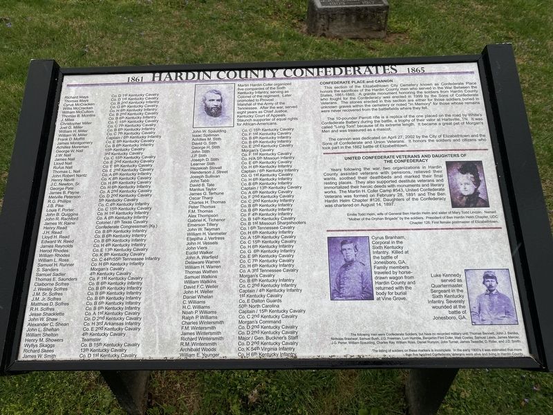
By Darren Jefferson Clay, April 10, 2021
Hardin County Confederates Marker
RANKED BY RELEVANCE
| Near East Dixie Avenue at Browns Court, on the right when traveling south. |
| On West Dixie Avenue at North Mulberry Street (U.S. 62), on the right when traveling west on West Dixie Avenue. |
| On West Broadway (Kentucky Route 448) at Old State Road ( Route 710), on the left when traveling north on West Broadway. |
| On Lincoln Blvd (Kentucky Route 210) north of West Main Street ( Route 2426), on the left when traveling south. |
| Near South College Street (U.S. 127) at West Lexington Street, on the right when traveling south. |
| Near Bardstown Road (U.S. 31E) north of White City Road ( Route 470), on the left when traveling north. |
| On Kessler Road, on the right when traveling south. |
| On 2nd Street (Business U.S. 60) at South Main Street ( Route 261), on the right when traveling east on 2nd Street. |
| Near East Lincoln Highway Road west of County Road 1300E. |
| On Freeman Lake Park Road at City Street-1197-20 (Route 1197-20) when traveling east on Freeman Lake Park Road. |
| Near 45th Street South just south of 15th Avenue South, on the right when traveling south. |
| Near Freeman Lake Park Road at City Street-1197-20, on the left when traveling east. |
| Near North Dixie Highway (U.S. 31W) 0.1 miles south of Diecks Drive, on the right when traveling north. |
| Near 68th Street at Beechtree Drive, on the right when traveling south. |
| Near Beechland Road (Kentucky Route 438) at Lincoln Park Road ( Route 528), on the left when traveling east. |
| On Lincoln Park Road (Kentucky Route 528) south of Fairlane Drive, on the left when traveling south. |
| On Pine Lake Road near South 30th Street. |
| Near Ada Road (Ohio Route 81) west of Slabtown Road, on the right when traveling east. |
| On W Dixie Avenue at N. Mulberry Street (U.S. 62), on the left when traveling east on W Dixie Avenue. |
| On Beechland Road (Kentucky Route 438) at Lincoln Park Road ( Route 528), on the left when traveling east on Beechland Road. |
| Near West 41st Street at Western Ave. |
| Near West 7th Street just west of Myrtle Avenue, on the right when traveling west. |
| Near Dixie Highway East at Brown Court, on the left when traveling north. |
| On East Dixie Avenue (Kentucky Route 61) at South Crestwood Street, on the left when traveling north on East Dixie Avenue. |
| On Dixie Highway (Kentucky Route 31W/60), on the right when traveling south. Reported missing. |
| On North Main Street at Plum Alley, on the right when traveling north on North Main Street. |
| On Interstate 55 at milepost 106. |
| On Beechland Road (Kentucky Route 438) 0.2 miles north of Berry Mill Road, on the right when traveling north. |
| Near Union Square W near E 17th Street, on the left when traveling south. Reported permanently removed. |
| On Railroad Street at Courtright Street (Ohio Route 195), on the left when traveling east on Railroad Street. |
| On Public Square (U.S. 31W) at North Main Street, on the right when traveling west on Public Square. |
| On Main Street (U.S. 64) east of Adams Street, on the right when traveling east. |
| On Public Square at South Main Street, on the left when traveling north on Public Square. |
| On North Main Street at Plum Alley, on the left when traveling north on North Main Street. |
| On West Dixie Avenue (U.S. 31W) north of Mulberry Street (U.S. 62). |
| On Union Square West at East 16th Street, on the right when traveling north on Union Square West. |
Thin black lines indicate changes in relevance. Between each pair of lines entries are ordered geographically but all have the same relevance.* Inflectional forms of words are their plurals, singulars, and possessives as well as gramatical tenses and similar variations.
Nov. 12, 2026
