17 entries match your criteria.
Missouri, Columbia, African-American Heritage Trail Historical Markers A 2-mile walking trail in central Columbia with dozens of historical markers highlighting Columbia’s black community. Centered around the Sharp End, the black business district that thrived until 1950s urban renewal projects destroyed much of Columbia’s vibrant black community, leaving only fading memories which the markers serve to recall.
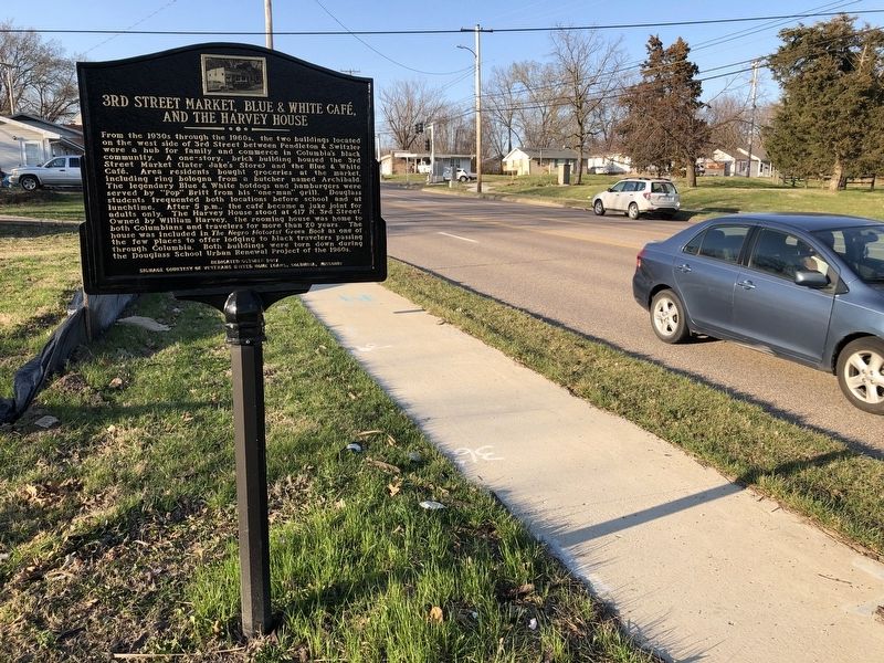
By Devry Becker Jones (CC0), March 21, 2021
3rd Street Market, Blue & White Café, and the Harvey House Marker
GEOGRAPHIC SORT Title Sort Marker Number Sort Marker Number Sort N Marker Number Sort T Publication Order Sort Publication Order Sort A Erected Year Sort Most Viewed Sort Most Recent-Interest Sort Most Recently Changed Sort SEE FAQ #33 FOR DESCRIPTIONS
On North Providence Road (State Highway 163) just north of Switzler Street, on the left when traveling north.
On Park Avenue just east of North Providence Street (State Highway 163), on the right when traveling east.
On East Broadway just east of North 4th Street, on the left when traveling east.
On North 5th Street at East Walnut Street, on the right when traveling north on North 5th Street.
On South 5th Street at Davis Street, on the right when traveling north on South 5th Street.
On North 5th Street just north of East Ash Street, on the left when traveling north.
On East Broadway, 0.1 miles west of North 1st Street, on the left when traveling west.
On North Garth Avenue at East Ash Street, on the right when traveling north on North Garth Avenue.
On North Providence Road (State Highway 163) at East Ash Street, on the left when traveling north on North Providence Road.
On Switzler Street just west of Lasalle Place, on the right when traveling west.
On South 4th Street at Cherry Street, on the right when traveling south on South 4th Street.
On Park Avenue at North 7th Street, on the right when traveling east on Park Avenue.
On North Providence Road (State Highway 163) just north of Switzler Street, on the right when traveling north.
Near South Providence Road (State Highway 163) 0.1 miles south of East Stewart Road, on the left when traveling north.
On East Walnut Street just east of North 5th Street, on the right when traveling east.
Paid Advertisement
On North 4th Street just north of East Broadway, on the right when traveling north.
On East Walnut Street at North 5th Street, on the right when traveling east on East Walnut Street.
Jun. 17, 2024